Pacho Formation
| Pacho Formation Stratigraphic range: Late Albian-Cenomanian ~102–97 Ma | |
|---|---|
| Type | Geological formation |
| Unit of | Villeta Group |
| Underlies | Simijaca Formation |
| Overlies | Hiló Formation |
| Thickness | ~1,050 m (3,440 ft) |
| Lithology | |
| Primary | Siltstone |
| Other | Shale |
| Location | |
| Coordinates | 4°27′07″N 74°03′20″W / 4.45194°N 74.05556°WCoordinates: 4°27′07″N 74°03′20″W / 4.45194°N 74.05556°W |
| Region |
Altiplano Cundiboyacense Eastern Ranges, Andes |
| Country |
|
| Type section | |
| Named for | Pacho |
| Named by | Ulloa |
| Location | Pacho |
| Year defined | 1982 |
| Coordinates | 4°27′07″N 74°03′20″W / 4.45194°N 74.05556°W |
| Region | Cundinamarca |
| Country |
|
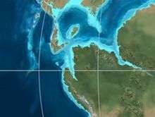
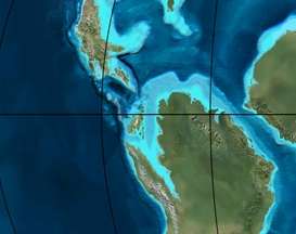 Paleogeography of Northern South America 105 Ma, by Ron Blakey | |
The Pacho Formation (Spanish: Limolitas de Pacho, Kslp) is a geological formation of the Altiplano Cundiboyacense, Eastern Ranges of the Colombian Andes. The formation consisting of alternating siltstones and shales with siderite concretions dates to the Middle Cretaceous period; Late Albian to Cenomanian epochs and has an approximate thickness of 1,050 metres (3,440 ft).
Etymology
The formation was defined and named in 1982 by Ulloa after Pacho, Cundinamarca.[1]
Description
Lithologies
The Pacho Formation has an approximate thickness of 1,050 metres (3,440 ft), and is characterised by a sequence of alternating siltstones and shales with siderite concretions.[1]
Stratigraphy and depositional environment
The Pacho Formation, pertaining to the Villeta Group, partly overlies and is partly lateral equivalent with the Hiló Formation and is partly overlain by and partly time equivalent with the Simijaca Formation. The age has been estimated to be Late Albian to Cenomanian. Stratigraphically, the formation is time equivalent with the Une Formation. The formation has been deposited in an outer marine platform environment.[1]
Outcrops
The Pacho Formation is found around its type locality near Pacho.[1]
Regional correlations
See also
References
Bibliography
- Acosta Garay, Jorge E., and Carlos E. Ulloa Melo. 2002. Mapa Geológico del Departamento de Cundinamarca - 1:250,000 - Memoria explicativa, 1–108. INGEOMINAS. Accessed 2017-04-26.
- Villamil, Tomas. 2012. Chronology Relative Sea Level History and a New Sequence Stratigraphic Model for Basinal Cretaceous Facies of Colombia, 161–216. Society for Sedimentary Geology (SEPM).
Maps
- Ulloa, Carlos, and Jorge Acosta. 1998. Plancha 208 - Villeta - 1:100,000, 1. INGEOMINAS. Accessed 2017-06-06.
- Ulloa, Carlos E; Erasmo Rodríguez, and Jorge E. Acosta. 1998. Plancha 227 - La Mesa - 1:100,000, 1. INGEOMINAS. Accessed 2017-06-06.
External links
- Gómez, J.; N.E. Montes; Á. Nivia, and H. Diederix. 2015. Plancha 5-09 del Atlas Geológico de Colombia 2015 – escala 1:500,000, 1. Servicio Geológico Colombiano. Accessed 2017-03-16.