Capotes Formation
| Capotes Formation Stratigraphic range: Early Albian ~112–108 Ma | |
|---|---|
| Type | Geological formation |
| Unit of | Villeta Group |
| Underlies | Hiló Formation |
| Overlies | El Peñón Fm., Socotá Fm. |
| Thickness | 550 m (1,800 ft) |
| Lithology | |
| Primary | Calcareous black shale |
| Other | Gypsum |
| Location | |
| Coordinates | 5°15′13″N 74°20′28″W / 5.25361°N 74.34111°WCoordinates: 5°15′13″N 74°20′28″W / 5.25361°N 74.34111°W |
| Region | Eastern Ranges, Andes |
| Country |
|
| Type section | |
| Named for | Hacienda Capotes, Viotá |
| Named by | Cáceres & Etayo |
| Location | Bituima-Guayabal |
| Year defined | 1969 |
| Coordinates | 5°15′13″N 74°20′28″W / 5.25361°N 74.34111°W |
| Region | Cundinamarca |
| Country |
|
| Thickness at type section | 550 m (1,800 ft) |
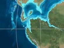
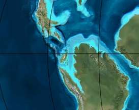 Paleogeography of Northern South America 105 Ma, by Ron Blakey | |
The Capotes Formation (Spanish: Formación Capotes, Kic) is a geological formation of the Altiplano Cundiboyacense, Eastern Ranges of the Colombian Andes. The formation consists of calcareous black shales containing gypsum and ammonites and dates to the Early Cretaceous period; Early Albian epoch and has an approximate thickness at its type section of 550 metres (1,800 ft).
Etymology
The formation was defined in 1969 by Cáceres and Etayo as a member of the Socotá Formation.[1][2] The name is derived from Hacienda Capotes, southeast of Viotá.[3]
Description
Lithologies
The Capotes Formation has a thickness at its type section of approximately 550 metres (1,800 ft), and is characterised by a sequence of organic rich calcareous shales with gypsum. Fossils of Douvilleiceras solitae, Neodeshayesites columbianus and Paracrioceras sp. have been found in the Capotes Formation.[2][4]
Stratigraphy and depositional environment
The Capotes Formation, part of the Villeta Group, overlies the Socotá and El Peñón Formations, and is overlain by the Hiló Formation. The age has been estimated to be Early Albian. Stratigraphically, the formation is time equivalent with the Simití Formation.[5] The formation has been deposited in a quiet enclosed shallow marine environment.[2] In terms of sequence stratigraphy, the Albian of current central Colombia experienced a transgressive to highstand sequence.[6]
Outcrops
The Capotes Formation is apart from its type locality along the road between Bituima and Guayabal,[2] also found north and southeast of Viotá,[7] and north and east of La Mesa.[8]
Regional correlations
See also
References
Bibliography
- Acosta Garay, Jorge E., and Carlos E. Ulloa Melo. 2002. Mapa Geológico del Departamento de Cundinamarca - 1:250,000 - Memoria explicativa, 1–108. INGEOMINAS. Accessed 2017-06-05.
- Acosta Garay, Jorge, and Carlos E Ulloa Melo. 2001. Geología de la Plancha 208 Villeta - 1:100,000, 1-84. INGEOMINAS. Accessed 2017-06-05.
- Moreno Bedmar, J.A; R. Martínez; J.V. Rodríguez, and Hermann Durán Bermúdez. 2015. Algunos ammonites del Cretácico de la Cordillera Oriental de Colombia, _. XV Congreso Colombiano de Geología, 2015. Accessed 2017-06-05.
- Vargas Quintero, Jhonn, and Daniel Mauricio Barrantas. 2013. Efectos del tránsito en la estabilidad de taludes, 1-185. Universidad La Javeriana.
- Villamil, Tomas. 2012. Chronology Relative Sea Level History and a New Sequence Stratigraphic Model for Basinal Cretaceous Facies of Colombia, 161–216. Society for Sedimentary Geology (SEPM).
Maps
- Ulloa, Carlos, and Jorge Acosta. 1998. Plancha 208 - Villeta - 1:100,000, 1. INGEOMINAS. Accessed 2017-06-06.
- Ulloa, Carlos E; Erasmo Rodríguez, and Jorge E. Acosta. 1998. Plancha 227 - La Mesa - 1:100,000, 1. INGEOMINAS. Accessed 2017-06-06.
- Acosta, Jorge E., and Carlos E. Ulloa. 1998. Plancha 246 - Fusagasugá - 1:100,000, 1. INGEOMINAS. Accessed 2017-06-06.
External links
- Gómez, J.; N.E. Montes; Á. Nivia, and H. Diederix. 2015. Plancha 5-09 del Atlas Geológico de Colombia 2015 – escala 1:500,000, 1. Servicio Geológico Colombiano. Accessed 2017-06-05.