Vaux d'Amognes
| Vaux d'Amognes | |
|---|---|
| Commune | |
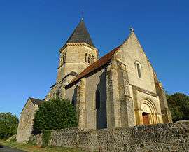 The church of Saint-Fiacre of Ourouër | |
 Vaux d'Amognes Location within Bourgogne-Franche-Comté region  Vaux d'Amognes | |
| Coordinates: 47°03′32″N 3°18′25″E / 47.059°N 3.307°ECoordinates: 47°03′32″N 3°18′25″E / 47.059°N 3.307°E | |
| Country | France |
| Region | Bourgogne-Franche-Comté |
| Department | Nièvre |
| Arrondissement | Nevers |
| Canton | Guérigny |
| Intercommunality | Le Bon Pays |
| Area1 | 37.84 km2 (14.61 sq mi) |
| Population (2013)2 | 558 |
| • Density | 15/km2 (38/sq mi) |
| Time zone | UTC+1 (CET) |
| • Summer (DST) | UTC+2 (CEST) |
| INSEE/Postal code | 58204 /58130 |
|
1 French Land Register data, which excludes lakes, ponds, glaciers > 1 km2 (0.386 sq mi or 247 acres) and river estuaries. 2 Population without double counting: residents of multiple communes (e.g., students and military personnel) only counted once. | |
Vaux d'Amognes is a commune in the department of Nièvre, central France. The municipality was established on 1 January 2017 by merger of the former communes of Ourouër (the seat) and Balleray.[1]
See also
References
| Wikimedia Commons has media related to Vaux d'Amognes. |
- ↑ Arrêté préfectoral 6 July 2016 (in French)
This article is issued from
Wikipedia.
The text is licensed under Creative Commons - Attribution - Sharealike.
Additional terms may apply for the media files.