Luthenay-Uxeloup
| Luthenay-Uxeloup | |
|---|---|
| Commune | |
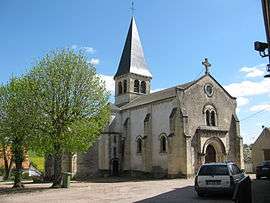 The church of Saint-Aignan, in Luthenay-Uxeloup | |
 Luthenay-Uxeloup Location within Bourgogne-Franche-Comté region  Luthenay-Uxeloup | |
| Coordinates: 46°51′05″N 3°15′51″E / 46.8514°N 3.2642°ECoordinates: 46°51′05″N 3°15′51″E / 46.8514°N 3.2642°E | |
| Country | France |
| Region | Bourgogne-Franche-Comté |
| Department | Nièvre |
| Arrondissement | Nevers |
| Canton | Saint-Pierre-le-Moûtier |
| Intercommunality | Nivernais Bourbonnais |
| Government | |
| • Mayor (2001–2008) | Frédéric Pignot |
| Area1 | 37.69 km2 (14.55 sq mi) |
| Population (1999)2 | 568 |
| • Density | 15/km2 (39/sq mi) |
| Time zone | UTC+1 (CET) |
| • Summer (DST) | UTC+2 (CEST) |
| INSEE/Postal code | 58148 /58240 |
| Elevation | 177–247 m (581–810 ft) |
|
1 French Land Register data, which excludes lakes, ponds, glaciers > 1 km2 (0.386 sq mi or 247 acres) and river estuaries. 2 Population without double counting: residents of multiple communes (e.g., students and military personnel) only counted once. | |
Luthenay-Uxeloup is a commune in the Nièvre department in central France.
See also
References
| Wikimedia Commons has media related to Luthenay-Uxeloup. |
This article is issued from
Wikipedia.
The text is licensed under Creative Commons - Attribution - Sharealike.
Additional terms may apply for the media files.