Saint-Loup, Nièvre
| Saint-Loup | |
|---|---|
| Commune | |
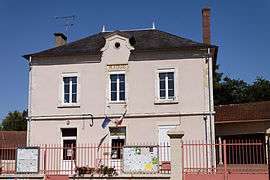 The town hall in Saint-Loup | |
 Saint-Loup Location within Bourgogne-Franche-Comté region  Saint-Loup | |
| Coordinates: 47°26′47″N 3°00′14″E / 47.4464°N 3.0039°ECoordinates: 47°26′47″N 3°00′14″E / 47.4464°N 3.0039°E | |
| Country | France |
| Region | Bourgogne-Franche-Comté |
| Department | Nièvre |
| Arrondissement | Cosne-Cours-sur-Loire |
| Canton | Cosne-Cours-sur-Loire |
| Intercommunality | Loire et Nohain |
| Government | |
| • Mayor (2001–2008) | Claude Bernot |
| Area1 | 17.28 km2 (6.67 sq mi) |
| Population (2006)2 | 474 |
| • Density | 27/km2 (71/sq mi) |
| Time zone | UTC+1 (CET) |
| • Summer (DST) | UTC+2 (CEST) |
| INSEE/Postal code | 58251 /58200 |
| Elevation | 188–283 m (617–928 ft) |
|
1 French Land Register data, which excludes lakes, ponds, glaciers > 1 km2 (0.386 sq mi or 247 acres) and river estuaries. 2 Population without double counting: residents of multiple communes (e.g., students and military personnel) only counted once. | |
Saint-Loup is a commune in the Nièvre department in central France. It has 457 inhabitants.
See also
References
| Wikimedia Commons has media related to Saint-Loup (Nièvre). |
This article is issued from
Wikipedia.
The text is licensed under Creative Commons - Attribution - Sharealike.
Additional terms may apply for the media files.