Arthel
| Arthel | |
|---|---|
| Commune | |
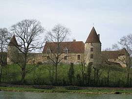 The Château de la Motte, in Arthel | |
 Arthel Location within Bourgogne-Franche-Comté region  Arthel | |
| Coordinates: 47°14′43″N 3°24′35″E / 47.2453°N 3.4097°ECoordinates: 47°14′43″N 3°24′35″E / 47.2453°N 3.4097°E | |
| Country | France |
| Region | Bourgogne-Franche-Comté |
| Department | Nièvre |
| Arrondissement | Cosne-Cours-sur-Loire |
| Canton | La Charité-sur-Loire |
| Intercommunality | CC Loire Nièvre Bertranges |
| Government | |
| • Mayor (2014-2020) | Marc Fauche |
| Area1 | 7.73 km2 (2.98 sq mi) |
| Population (2015)2 | 96 |
| • Density | 12/km2 (32/sq mi) |
| Time zone | UTC+1 (CET) |
| • Summer (DST) | UTC+2 (CEST) |
| INSEE/Postal code | 58013 /58700 |
| Elevation | 229–353 m (751–1,158 ft) |
|
1 French Land Register data, which excludes lakes, ponds, glaciers > 1 km2 (0.386 sq mi or 247 acres) and river estuaries. 2 Population without double counting: residents of multiple communes (e.g., students and military personnel) only counted once. | |
Arthel is a commune in the Nièvre department in central France.
Population
| Historical population | ||
|---|---|---|
| Year | Pop. | ±% |
| 1962 | 151 | — |
| 1968 | 161 | +6.6% |
| 1975 | 151 | −6.2% |
| 1982 | 120 | −20.5% |
| 1990 | 97 | −19.2% |
| 1999 | 70 | −27.8% |
| 2006 | 85 | +21.4% |
| 2009 | 91 | +7.1% |
| 2015 | 96 | +5.5% |
See also
References
| Wikimedia Commons has media related to Arthel. |
This article is issued from
Wikipedia.
The text is licensed under Creative Commons - Attribution - Sharealike.
Additional terms may apply for the media files.