Ternant, Nièvre
| Ternant | |
|---|---|
| Commune | |
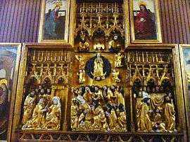 The retable of the Virgin, in the church of Saint-Roch | |
 Ternant Location within Bourgogne-Franche-Comté region  Ternant | |
| Coordinates: 46°45′04″N 3°50′23″E / 46.7511°N 3.8397°ECoordinates: 46°45′04″N 3°50′23″E / 46.7511°N 3.8397°E | |
| Country | France |
| Region | Bourgogne-Franche-Comté |
| Department | Nièvre |
| Arrondissement | Château-Chinon (Ville) |
| Canton | Luzy |
| Intercommunality | Loire et Morvan |
| Area1 | 19.38 km2 (7.48 sq mi) |
| Population (1999)2 | 237 |
| • Density | 12/km2 (32/sq mi) |
| Time zone | UTC+1 (CET) |
| • Summer (DST) | UTC+2 (CEST) |
| INSEE/Postal code | 58289 /58250 |
| Elevation | 231–415 m (758–1,362 ft) |
|
1 French Land Register data, which excludes lakes, ponds, glaciers > 1 km2 (0.386 sq mi or 247 acres) and river estuaries. 2 Population without double counting: residents of multiple communes (e.g., students and military personnel) only counted once. | |
Ternant is a commune in the Nièvre department in central France.
Demographics
At the 1999 census, the population was 237. On 1 January 2006, the estimate was 206.
See also
References
- Notes
| Wikimedia Commons has media related to Ternant (Nièvre). |
This article is issued from
Wikipedia.
The text is licensed under Creative Commons - Attribution - Sharealike.
Additional terms may apply for the media files.