Nannay
| Nannay | |
|---|---|
| Commune | |
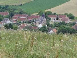 The church and surrounding buildings in Nannay | |
 Nannay Location within Bourgogne-Franche-Comté region  Nannay | |
| Coordinates: 47°15′47″N 3°11′31″E / 47.2631°N 3.1919°ECoordinates: 47°15′47″N 3°11′31″E / 47.2631°N 3.1919°E | |
| Country | France |
| Region | Bourgogne-Franche-Comté |
| Department | Nièvre |
| Arrondissement | Cosne-Cours-sur-Loire |
| Canton | La Charité-sur-Loire |
| Intercommunality | Pays Charitois |
| Government | |
| • Mayor (2001–2008) | Dany Seutin |
| Area1 | 11.44 km2 (4.42 sq mi) |
| Population (1999)2 | 100 |
| • Density | 8.7/km2 (23/sq mi) |
| Time zone | UTC+1 (CET) |
| • Summer (DST) | UTC+2 (CEST) |
| INSEE/Postal code | 58188 /58350 |
| Elevation | 185–353 m (607–1,158 ft) |
|
1 French Land Register data, which excludes lakes, ponds, glaciers > 1 km2 (0.386 sq mi or 247 acres) and river estuaries. 2 Population without double counting: residents of multiple communes (e.g., students and military personnel) only counted once. | |
Nannay is a commune in the Nièvre department in central France.
Demographics
At the 1999 census, the population was 100. On 1 January 2005, the estimate was 121.
See also
References
External links
| Wikimedia Commons has media related to Nannay. |
- Official website (in French)
This article is issued from
Wikipedia.
The text is licensed under Creative Commons - Attribution - Sharealike.
Additional terms may apply for the media files.