Mhère
| Mhère | |
|---|---|
| Commune | |
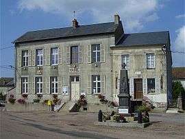 The town hall in Mhère | |
 Mhère Location within Bourgogne-Franche-Comté region  Mhère | |
| Coordinates: 47°12′29″N 3°51′24″E / 47.2081°N 3.8567°ECoordinates: 47°12′29″N 3°51′24″E / 47.2081°N 3.8567°E | |
| Country | France |
| Region | Bourgogne-Franche-Comté |
| Department | Nièvre |
| Arrondissement | Clamecy |
| Canton | Corbigny |
| Intercommunality | Pays Corbigeois |
| Government | |
| • Mayor (2001–2008) | Henri Taché |
| Area1 | 25.25 km2 (9.75 sq mi) |
| Population (1999)2 | 279 |
| • Density | 11/km2 (29/sq mi) |
| Time zone | UTC+1 (CET) |
| • Summer (DST) | UTC+2 (CEST) |
| INSEE/Postal code | 58166 /58140 |
| Elevation | 255–550 m (837–1,804 ft) |
|
1 French Land Register data, which excludes lakes, ponds, glaciers > 1 km2 (0.386 sq mi or 247 acres) and river estuaries. 2 Population without double counting: residents of multiple communes (e.g., students and military personnel) only counted once. | |
Mhère is a commune in the Nièvre department in central France.
According to the Institut Géographique National, between 1 January 2007 and 1 January 2008, Mhère was the geographic centre of the Eurozone, after its enlargement to Slovenia.[1] With the admission of Cyprus and Malta, this centre was moved to Ouroux-en-Morvan.
Demographics
At the 1999 census, the population was 279. On 1 January 2004, the estimate was 291.
See also
References
Notes
- ↑ Centre de l’Euroland, IGN Archived 2007-10-31 at the Wayback Machine.
| Wikimedia Commons has media related to Mhère. |
This article is issued from
Wikipedia.
The text is licensed under Creative Commons - Attribution - Sharealike.
Additional terms may apply for the media files.