Montigny-aux-Amognes
| Montigny-aux-Amognes | |
|---|---|
| Commune | |
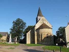 The church of Saint-Louis, in Montigny | |
 Montigny-aux-Amognes Location within Bourgogne-Franche-Comté region  Montigny-aux-Amognes | |
| Coordinates: 47°01′42″N 3°17′27″E / 47.0283°N 3.2908°ECoordinates: 47°01′42″N 3°17′27″E / 47.0283°N 3.2908°E | |
| Country | France |
| Region | Bourgogne-Franche-Comté |
| Department | Nièvre |
| Arrondissement | Nevers |
| Canton | Guérigny |
| Intercommunality | Amognes |
| Government | |
| • Mayor (2001–2008) | Philippe Graillot |
| Area1 | 25.17 km2 (9.72 sq mi) |
| Population (1999)2 | 515 |
| • Density | 20/km2 (53/sq mi) |
| Time zone | UTC+1 (CET) |
| • Summer (DST) | UTC+2 (CEST) |
| INSEE/Postal code | 58176 /58130 |
| Elevation | 184–302 m (604–991 ft) |
|
1 French Land Register data, which excludes lakes, ponds, glaciers > 1 km2 (0.386 sq mi or 247 acres) and river estuaries. 2 Population without double counting: residents of multiple communes (e.g., students and military personnel) only counted once. | |
Montigny-aux-Amognes is a commune in the Nièvre department in central France.
See also
References
| Wikimedia Commons has media related to Montigny-aux-Amognes. |
This article is issued from
Wikipedia.
The text is licensed under Creative Commons - Attribution - Sharealike.
Additional terms may apply for the media files.