Myennes
| Myennes | |
|---|---|
| Commune | |
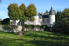 The Chateau of Myennes | |
 Myennes Location within Bourgogne-Franche-Comté region  Myennes | |
| Coordinates: 47°26′50″N 2°56′05″E / 47.4472°N 2.9347°ECoordinates: 47°26′50″N 2°56′05″E / 47.4472°N 2.9347°E | |
| Country | France |
| Region | Bourgogne-Franche-Comté |
| Department | Nièvre |
| Arrondissement | Cosne-Cours-sur-Loire |
| Canton | Cosne-Cours-sur-Loire |
| Intercommunality | Loire et Nohain |
| Government | |
| • Mayor (2001–2008) | Françoise Pillard |
| Area1 | 7.40 km2 (2.86 sq mi) |
| Population (1999)2 | 557 |
| • Density | 75/km2 (190/sq mi) |
| Time zone | UTC+1 (CET) |
| • Summer (DST) | UTC+2 (CEST) |
| INSEE/Postal code | 58187 /58440 |
| Elevation | 136–217 m (446–712 ft) |
|
1 French Land Register data, which excludes lakes, ponds, glaciers > 1 km2 (0.386 sq mi or 247 acres) and river estuaries. 2 Population without double counting: residents of multiple communes (e.g., students and military personnel) only counted once. | |
Myennes is a commune in the Nièvre department in central France.
Demographics
At the 1999 census, the population was 557. On 1 January 2006, the estimate was 582.
See also
References
| Wikimedia Commons has media related to Myennes. |
This article is issued from
Wikipedia.
The text is licensed under Creative Commons - Attribution - Sharealike.
Additional terms may apply for the media files.