Alluy
| Alluy | |
|---|---|
| Commune | |
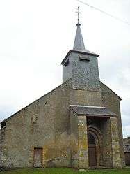 The church of Saint-Pierre and Saint-Paul, in Alluy | |
 Alluy Location within Bourgogne-Franche-Comté region  Alluy | |
| Coordinates: 47°02′05″N 3°38′30″E / 47.0347°N 3.6417°ECoordinates: 47°02′05″N 3°38′30″E / 47.0347°N 3.6417°E | |
| Country | France |
| Region | Bourgogne-Franche-Comté |
| Department | Nièvre |
| Arrondissement | Château-Chinon |
| Canton | Château-Chinon |
| Intercommunality | Bazois |
| Government | |
| • Mayor (2014-2020) | Patrice Bonnet |
| Area1 | 27.44 km2 (10.59 sq mi) |
| Population (2014)2 | 401 |
| • Density | 15/km2 (38/sq mi) |
| Time zone | UTC+1 (CET) |
| • Summer (DST) | UTC+2 (CEST) |
| INSEE/Postal code | 58004 /58110 |
| Elevation | 221–287 m (725–942 ft) |
|
1 French Land Register data, which excludes lakes, ponds, glaciers > 1 km2 (0.386 sq mi or 247 acres) and river estuaries. 2 Population without double counting: residents of multiple communes (e.g., students and military personnel) only counted once. | |
Alluy is a commune in the Nièvre department in central France.
Population
| Historical population | ||
|---|---|---|
| Year | Pop. | ±% |
| 1962 | 492 | — |
| 1968 | 526 | +6.9% |
| 1975 | 521 | −1.0% |
| 1982 | 443 | −15.0% |
| 1990 | 449 | +1.4% |
| 1999 | 403 | −10.2% |
| 2006 | 423 | +5.0% |
| 2009 | 420 | −0.7% |
See also
References
| Wikimedia Commons has media related to Alluy. |
This article is issued from
Wikipedia.
The text is licensed under Creative Commons - Attribution - Sharealike.
Additional terms may apply for the media files.