Bazolles
| Bazolles | |
|---|---|
| Commune | |
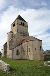 The church of Saint-Symphorien, in Bazolles | |
 Bazolles Location within Bourgogne-Franche-Comté region  Bazolles | |
| Coordinates: 47°08′35″N 3°37′04″E / 47.1431°N 3.6178°ECoordinates: 47°08′35″N 3°37′04″E / 47.1431°N 3.6178°E | |
| Country | France |
| Region | Bourgogne-Franche-Comté |
| Department | Nièvre |
| Arrondissement | Nevers |
| Canton | Guérigny |
| Government | |
| • Mayor (2008–2014) | Jocelyne Baroin |
| Area1 | 28.57 km2 (11.03 sq mi) |
| Population (2009)2 | 282 |
| • Density | 9.9/km2 (26/sq mi) |
| Time zone | UTC+1 (CET) |
| • Summer (DST) | UTC+2 (CEST) |
| INSEE/Postal code | 58024 /58110 |
| Elevation | 245–302 m (804–991 ft) |
|
1 French Land Register data, which excludes lakes, ponds, glaciers > 1 km2 (0.386 sq mi or 247 acres) and river estuaries. 2 Population without double counting: residents of multiple communes (e.g., students and military personnel) only counted once. | |
Bazolles is a commune in the Nièvre department in central France.
Population
| Historical population | ||
|---|---|---|
| Year | Pop. | ±% |
| 1962 | 427 | — |
| 1968 | 440 | +3.0% |
| 1975 | 325 | −26.1% |
| 1982 | 320 | −1.5% |
| 1990 | 260 | −18.8% |
| 1999 | 265 | +1.9% |
| 2006 | 272 | +2.6% |
| 2009 | 282 | +3.7% |
See also
References
| Wikimedia Commons has media related to Bazolles. |
This article is issued from
Wikipedia.
The text is licensed under Creative Commons - Attribution - Sharealike.
Additional terms may apply for the media files.