Poil
| Poil | |
|---|---|
| Commune | |
 Poil Location within Bourgogne-Franche-Comté region  Poil | |
| Coordinates: 46°52′04″N 4°04′28″E / 46.8678°N 4.0744°ECoordinates: 46°52′04″N 4°04′28″E / 46.8678°N 4.0744°E | |
| Country | France |
| Region | Bourgogne-Franche-Comté |
| Department | Nièvre |
| Arrondissement | Château-Chinon |
| Canton | Luzy |
| Intercommunality | Alène et la Roche |
| Government | |
| • Mayor (2014–2017) | Christian Courault |
| Area1 | 27.02 km2 (10.43 sq mi) |
| Population (1999)2 | 189 |
| • Density | 7.0/km2 (18/sq mi) |
| Time zone | UTC+1 (CET) |
| • Summer (DST) | UTC+2 (CEST) |
| INSEE/Postal code | 58211 /58170 |
| Elevation | 297–522 m (974–1,713 ft) |
|
1 French Land Register data, which excludes lakes, ponds, glaciers > 1 km2 (0.386 sq mi or 247 acres) and river estuaries. 2 Population without double counting: residents of multiple communes (e.g., students and military personnel) only counted once. | |
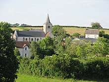
General view with the church Saint-Romain.
Poil is a commune in the Nièvre department in central France.
Geography
The commune is part of the parc naturel régional du Morvan.
The river Alène has its source in the south-western part of the commune.
Demographics
At the 1999 census, the population was 189. On 1 January 2005, the estimate was 158. 'Poil' is also a rarely used English name of French origin
See also
References
| Wikimedia Commons has media related to Poil (Nièvre). |
This article is issued from
Wikipedia.
The text is licensed under Creative Commons - Attribution - Sharealike.
Additional terms may apply for the media files.