Chantenay-Saint-Imbert
| Chantenay-Saint-Imbert | |
|---|---|
| Commune | |
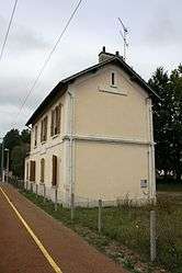 Chantenay-Saint-Imbert railway station | |
 Chantenay-Saint-Imbert Location within Bourgogne-Franche-Comté region  Chantenay-Saint-Imbert | |
| Coordinates: 46°44′01″N 3°11′05″E / 46.7336°N 3.1847°ECoordinates: 46°44′01″N 3°11′05″E / 46.7336°N 3.1847°E | |
| Country | France |
| Region | Bourgogne-Franche-Comté |
| Department | Nièvre |
| Arrondissement | Nevers |
| Canton | Saint-Pierre-le-Moûtier |
| Intercommunality | Nivernais Bourbonnais |
| Government | |
| • Mayor (2001–2008) | Jean Aubois |
| Area1 | 41.69 km2 (16.10 sq mi) |
| Population (1999)2 | 1,190 |
| • Density | 29/km2 (74/sq mi) |
| Time zone | UTC+1 (CET) |
| • Summer (DST) | UTC+2 (CEST) |
| INSEE/Postal code | 58057 /58240 |
| Elevation | 182–262 m (597–860 ft) |
|
1 French Land Register data, which excludes lakes, ponds, glaciers > 1 km2 (0.386 sq mi or 247 acres) and river estuaries. 2 Population without double counting: residents of multiple communes (e.g., students and military personnel) only counted once. | |
Chantenay-Saint-Imbert is a commune in the Nièvre department in central France.
Demographics
At the 1999 census, the population was 1,190.
See also
References
| Wikimedia Commons has media related to Chantenay-Saint-Imbert. |
This article is issued from
Wikipedia.
The text is licensed under Creative Commons - Attribution - Sharealike.
Additional terms may apply for the media files.