Armes, Nièvre
| Armes | ||
|---|---|---|
| Commune | ||
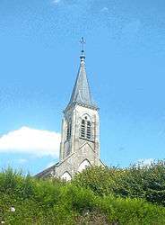 The church in Armes | ||
| ||
 Armes Location within Bourgogne-Franche-Comté region  Armes | ||
| Coordinates: 47°27′34″N 3°32′55″E / 47.4594°N 3.5486°ECoordinates: 47°27′34″N 3°32′55″E / 47.4594°N 3.5486°E | ||
| Country | France | |
| Region | Bourgogne-Franche-Comté | |
| Department | Nièvre | |
| Arrondissement | Clamecy | |
| Canton | Clamecy | |
| Intercommunality | CC Haut Nivernais Val Yonne | |
| Government | ||
| • Mayor (2014-2020) | Guy Wendehenne | |
| Area1 | 8.49 km2 (3.28 sq mi) | |
| Population (2015)2 | 298 | |
| • Density | 35/km2 (91/sq mi) | |
| Time zone | UTC+1 (CET) | |
| • Summer (DST) | UTC+2 (CEST) | |
| INSEE/Postal code | 58011 /58500 | |
| Elevation | 147–252 m (482–827 ft) | |
|
1 French Land Register data, which excludes lakes, ponds, glaciers > 1 km2 (0.386 sq mi or 247 acres) and river estuaries. 2 Population without double counting: residents of multiple communes (e.g., students and military personnel) only counted once. | ||
.svg.png)
Armes is a commune in the Nièvre department in central France.
Population
| Historical population | ||
|---|---|---|
| Year | Pop. | ±% |
| 1962 | 299 | — |
| 1968 | 307 | +2.7% |
| 1975 | 325 | +5.9% |
| 1982 | 293 | −9.8% |
| 1990 | 244 | −16.7% |
| 1999 | 279 | +14.3% |
| 2006 | 287 | +2.9% |
| 2007 | 288 | +0.3% |
| 2009 | 281 | −2.4% |
| 2015 | 298 | +6.0% |
See also
References
| Wikimedia Commons has media related to Armes, Nièvre. |
This article is issued from
Wikipedia.
The text is licensed under Creative Commons - Attribution - Sharealike.
Additional terms may apply for the media files.