Montigny-sur-Canne
| Montigny-sur-Canne | |
|---|---|
| Commune | |
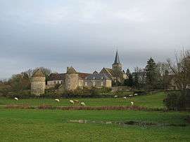 A general view of Montigny-sur-Canne | |
 Montigny-sur-Canne Location within Bourgogne-Franche-Comté region  Montigny-sur-Canne | |
| Coordinates: 46°56′00″N 3°39′22″E / 46.9333°N 3.6561°ECoordinates: 46°56′00″N 3°39′22″E / 46.9333°N 3.6561°E | |
| Country | France |
| Region | Bourgogne-Franche-Comté |
| Department | Nièvre |
| Arrondissement | Château-Chinon (Ville) |
| Canton | Luzy |
| Intercommunality | Bazois |
| Government | |
| • Mayor (2001–2008) | Pierre Reveniaud |
| Area1 | 30.36 km2 (11.72 sq mi) |
| Population (1999)2 | 185 |
| • Density | 6.1/km2 (16/sq mi) |
| Time zone | UTC+1 (CET) |
| • Summer (DST) | UTC+2 (CEST) |
| INSEE/Postal code | 58178 /58340 |
| Elevation | 202–277 m (663–909 ft) |
|
1 French Land Register data, which excludes lakes, ponds, glaciers > 1 km2 (0.386 sq mi or 247 acres) and river estuaries. 2 Population without double counting: residents of multiple communes (e.g., students and military personnel) only counted once. | |
Montigny-sur-Canne is a commune in the Nièvre department in central France.
See also
References
| Wikimedia Commons has media related to Montigny-sur-Canne. |
This article is issued from
Wikipedia.
The text is licensed under Creative Commons - Attribution - Sharealike.
Additional terms may apply for the media files.