Caballos Formation
| Caballos Formation Stratigraphic range: Aptian-Albian ~120–100 Ma | |
|---|---|
| Type | Geological formation |
| Underlies | Hondita Formation |
| Overlies | Yaví Fm., Saldaña Fm. |
| Thickness | up to 411 m (1,348 ft) |
| Lithology | |
| Primary | Sandstone, shale, siltstone |
| Other | Limestone, coal |
| Location | |
| Coordinates | 3°49′18.9″N 75°21′22.4″W / 3.821917°N 75.356222°WCoordinates: 3°49′18.9″N 75°21′22.4″W / 3.821917°N 75.356222°W |
| Region |
VSM & Caguán-Putumayo Basin Central & Eastern Ranges, Andes |
| Country |
|
| Type section | |
| Named for | Cerro Caballos |
| Named by | Corrigan |
| Location | Olaya Herrera |
| Year defined | 1967 |
| Coordinates | 3°49′18.9″N 75°21′22.4″W / 3.821917°N 75.356222°W |
| Approximate paleocoordinates | 2°54′S 47°24′W / 2.9°S 47.4°W |
| Region | Tolima |
| Country |
|
| Thickness at type section | 411 m (1,348 ft) |
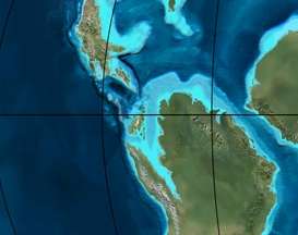 Paleogeography of Northern South America 105 Ma, by Ron Blakey | |
The Caballos Formation (Spanish: Formación Caballos, KI) is a geological formation of the Upper Magdalena Valley (VSM), Caguán-Putumayo Basin, Central and Eastern Ranges of the Colombian Andes. The sandstone and shale formation dates to the Middle Cretaceous period; Aptian to Albian epochs and has a maximum thickness of 411 metres (1,348 ft).
Etymology
The formation was defined and named in 1967 by Corrigan after Cerro Caballos, to the west of Olaya Herrera, Tolima.[1]
Description
Lithologies
The Caballos Formation has a maximum thickness of 411 metres (1,348 ft) in the Quebrada Bambucá and is characterized by a lower sequence of fine to coarse sandstones, of lithic arenite, quartz arenite and feldspar arenite composition, a middle section of fossiliferous black shales and siltstones, intercalated by micritic limestones and coals and very fine sandstones. The upper part of the formation contains conglomerates and glauconitic sandstones.[1]
Stratigraphy and depositional environment
The Caballos Formation in some parts concordantly overlies the Yaví Formation and in other parts rests unconformably on the Saldaña Formation and Ibagué Batholith.[2] The formation is overlain by the Hondita Formation. The age has been estimated to be Aptian to Albian. Stratigraphically, the formation is time equivalent with the Une, Aguardiente, Simijaca, El Peñón, Capotes, Tablazo, Tibú-Mercedes and Pacho Formations.[3] The formation has been deposited in a fluvial to estuarine and shallow marine environment.[4]
The Caballos Formation is a source, reservoir and seal rock in the Upper Magdalena Valley,[5][6] and a source and reservoir rock in the Caguán-Putumayo Basin.[7][8] The Orito and Moqueta Fields of the latter basin produce from Caballos reservoirs.
Fossil content
The formation has provided fossils of Heminautilus etheringtoni,[9] Araucarites sp., Brachyphyllum sp., Cladophlebis sp., and Weichselia sp.,[10] as well as many types of pollen.[11]
Outcrops
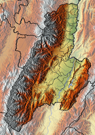
The Caballos Formation is apart from its type locality, found in Huila, Tolima and Putumayo Departments.
See also
References
- 1 2 Velandia et al., 2001, p.53
- ↑ Velandia et al., 2001, p.34
- ↑ Velandia et al., 2001, p.54
- ↑ Villamil, 2012, p.166
- ↑ ANH, 2007, p.84
- ↑ García González et al., 2009, p.83
- ↑ ANH, 2007, p.57
- ↑ García González et al., 2009, p.16
- ↑ Badouin et al., 2016, p.87
- ↑ Monje et al., 2016, p.38
- ↑ Los Mangos at Fossilworks.org
Bibliography
- Badouin, Cyril; Gérard Delanoy; Josep Antón Moreno Bedmar; Antoine Pictet; Jean Vermeulen; Gabriel Conte; Roland Gonnet; Patrick Boselli, and Marc Bonelli. 2016. Revision of the Early Cretaceous genera Heminautilus SPATH, 1927, and Josanautilus MARTÍNEZ & GRAUGES, 2006 (Nautilida, Cenoceratidae). Carnets Geologicás 16. 61–212. Accessed 2017-01-20.
- Barrero, Dario; Andrés Pardo; Carlos A. Vargas, and Juan F. Martínez. 2007. Colombian Sedimentary Basins: Nomenclature, Boundaries and Petroleum Geology, a New Proposal, 1–92. ANH.
- García González, Mario; Ricardo Mier Umaña; Luis Enrique Cruz Guevara, and Mauricio Vásquez. 2009. Informe Ejecutivo - evaluación del potencial hidrocarburífero de las cuencas colombianas, 1–219. Universidad Industrial de Santander.
- Monje Durán, Camila; Camila Martínez; Ignacio Escapa, and Santiago Madriñán. 2016. Nuevos registros de helechos y coníferas del Cretácico Inferior en la cuenca del Valle Superior del Magdalena, Colombia. Boletín de Geología, Universidad Industrial de Santander 38. 29–42. Accessed 2017-03-31.
- Núñez Tello, Alberto. 2003. Cartografía geológica de las zonas Andina Sur y Garzón-Quetame (Colombia) - Memoria explicativa de las planchas 411 La Cruz, 412 San Juan de Villalobos, 430 Mocoa, 431 Piamonte, 448 Monopamba, 449 Orito y 465 Churuyaco, 1–298. INGEOMINAS.
- Velandia P., Francisco; Alberto Núñez T., and Germán Marquínez. 2001. Mapa Geológico del Departamento del Huila - 1:300,000 - Memoria explicativa, 1–152. INGEOMINAS.
- Villamil, Tomas. 2012. Chronology Relative Sea Level History and a New Sequence Stratigraphic Model for Basinal Cretaceous Facies of Colombia, 161–216. Society for Sedimentary Geology (SEPM).
Maps
- Marquínez, Germán, and Francisco Velandia. 2001. Mapa Geológico del Huila 1:300,000, 1. INGEOMINAS. Accessed 2017-09-21.
- Fuquen, Jaime A., and Alberto Nuñez. 2003. Mapa Geológico del Putumayo 1:400,000, 1. INGEOMINAS. Accessed 2017-09-21.
- Acosta, Jorge E.; Rafael Guatame; Oscar Torres, and Frank Solano. 1999. Plancha 245 - Girardot - 1:100,000, 1. INGEOMINAS. Accessed 2017-06-06.
- Nuñez, Alberto; Dario Mosquera, and Carlos J. Vesga. 2009. Plancha 263 - Ortega - 1:100,000, 1. INGEOMINAS. Accessed 2017-06-06.
- Calcedo, Juan Carlos, and Roberto Terraza. 2000. Plancha 264 - Espinal - 1:100,000, 1. INGEOMINAS. Accessed 2017-06-06.
- Acosta, Jorge; Juan Carlos Calcedo, and Carlos Ulloa. 1999. Plancha 265 - Icononzo - 1:100,000, 1. INGEOMINAS. Accessed 2017-06-06.
- Carvajal, Cesar; Jaime Fuquen, and Luis Gómez. 1993. Plancha 282 - Chaparral - 1:100,000, 1. INGEOMINAS. Accessed 2017-06-06.
- Cossio, Ubaldo; Gabriel Rodríguez, and Miguel Rodríguez. 1995. Plancha 283 - Purificación - 1:100,000, 1. INGEOMINAS. Accessed 2017-06-06.
- Fuquen, Jaime; Gabriel Rodríguez; Ubaldo Cossio, and Alberto Núñez. 1993. Plancha 302 - Aipe - 1:100,000, 1. INGEOMINAS. Accessed 2017-06-06.
- Acosta, Jorge; Pablo Caro; Jaime Fuquen, and José Osorno. 2002. Plancha 303 - Colombia - 1:100,000, 1. INGEOMINAS.
- Gómez, Jorge; Carlos Morales; Germán Marquínez, and Francisco Velandia. 1999. Plancha 322 - Santa María - 1:100,000, 1. INGEOMINAS. Accessed 2017-06-06.
- Ferreira, Paulina; Alberto Núñez, and Miguel Rodríguez. 1998. Plancha 323 - Neiva - 1:100,000, 1. INGEOMINAS. Accessed 2017-06-06.
- Marquínez, Germán; C. Morales, and Alberto Núñez. 1999. Plancha 344 - Tesalia - 1:100,000, 1. INGEOMINAS. Accessed 2017-06-06.
- Velandia, F.; C.J. Morales; J.C. Caicedo, and Alberto Núñez. 1999. Plancha 345 - Campoalegre - 1:100,000, 1. INGEOMINAS. Accessed 2017-06-06.
- Marquínez, Germán; Yohana Rodríguez; Roberto Terraza, and Mario Martínez. 2003. Plancha 365 - Coconuco - 1:100,000, 1. INGEOMINAS. Accessed 2017-06-06.
- Rodríguez, Gabriel; Paulina Ferreira; Francisco Velandia, and Alberto Núñez. 1998. Plancha 366 - Garzón - 1:100,000, 1. INGEOMINAS. Accessed 2017-06-06.
- Rodríguez, Gabriel; Gilberto Zapata, and M. Velázquez. 2003. Plancha 389 - Timaná - 1:100,000, 1. INGEOMINAS. Accessed 2017-06-06.
- Núñez, Alberto, and Jorge Gómez. 2002. Plancha 411 - La Cruz - 1:100,000, 1. INGEOMINAS. Accessed 2017-06-06.
- Núñez, Alberto, and Jorge Gómez. 2002. Plancha 412 - San Juan de Villalobos - 1:100,000, 1. INGEOMINAS. Accessed 2017-06-06.
- Núñez, Alberto, and Jorge Gómez. 2002. Plancha 430 - Mocoa - 1:100,000, 1. INGEOMINAS. Accessed 2017-06-06.
- Núñez, Alberto, and Jorge Gómez. 2002. Plancha 431 - Piamonte - 1:100,000, 1. INGEOMINAS. Accessed 2017-06-06.
- Núñez, Alberto, and Jorge Gómez. 2002. Plancha 448 - Monopamba - 1:100,000, 1. INGEOMINAS. Accessed 2017-06-06.
- Núñez, Alberto, and Jorge Gómez. 2002. Plancha 449 - Orito - 1:100,000, 1. INGEOMINAS. Accessed 2017-06-06.
- Núñez, Alberto, and Jorge Gómez. 2002. Plancha 465 - Churiyaco - 1:100,000, 1. INGEOMINAS. Accessed 2017-06-06.