Tōmi, Nagano
| Tōmi 東御市 | |||
|---|---|---|---|
| City | |||
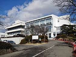 Tōmi City Hall | |||
| |||
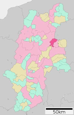 Location of Tōmi in Nagano Prefecture | |||
 Tōmi | |||
| Coordinates: 36°21′33.8″N 138°19′49.4″E / 36.359389°N 138.330389°ECoordinates: 36°21′33.8″N 138°19′49.4″E / 36.359389°N 138.330389°E | |||
| Country | Japan | ||
| Region | Chūbu (Kōshin'etsu) | ||
| Prefecture | Nagano | ||
| Area | |||
| • Total | 112.37 km2 (43.39 sq mi) | ||
| Population (October 2016) | |||
| • Total | 29,726 | ||
| • Density | 265/km2 (690/sq mi) | ||
| Time zone | UTC+9 (Japan Standard Time) | ||
| Symbols | |||
| • Tree | Black Walnut | ||
| • Flower | Azalea | ||
| Address | 281-2 Agata, Tōmi-shi, Nagano-ken 389-0592 | ||
| Website | http://www.city.tomi.nagano.jp/ | ||


Tōmi (東御市 Tōmi-shi) is a city located in Nagano Prefecture, Japan. As of 1 October 2016, the city had an estimated population of 29,726, and a population density of 265 persons per km². Its total area is 112.37 square kilometres (43.39 sq mi).
Geography
Tōmi is located in central Nagano Prefecture, at an elevation of between 500 and 1000 meters. The Chikuma River divides the city into two parts.
Surrounding municipalities
Climate
Due to its elevation, Tōmi has a humid continental climate (Köppen Dfb).. Winters are cold and very snowy, while summers are very warm and wet.
| Climate data for Tōmi (1981-2010) | |||||||||||||
|---|---|---|---|---|---|---|---|---|---|---|---|---|---|
| Month | Jan | Feb | Mar | Apr | May | Jun | Jul | Aug | Sep | Oct | Nov | Dec | Year |
| Average high °C (°F) | 2.4 (36.3) |
3.0 (37.4) |
7.4 (45.3) |
14.6 (58.3) |
19.6 (67.3) |
22.6 (72.7) |
26.1 (79) |
27.5 (81.5) |
22.8 (73) |
16.8 (62.2) |
11.4 (52.5) |
5.7 (42.3) |
15.0 (59) |
| Daily mean °C (°F) | −2.6 (27.3) |
−2.2 (28) |
1.5 (34.7) |
8.0 (46.4) |
13.2 (55.8) |
17.0 (62.6) |
20.7 (69.3) |
21.7 (71.1) |
17.4 (63.3) |
11.0 (51.8) |
5.5 (41.9) |
0.3 (32.5) |
9.3 (48.7) |
| Average low °C (°F) | −7.4 (18.7) |
−7.3 (18.9) |
−3.9 (25) |
1.9 (35.4) |
7.3 (45.1) |
12.4 (54.3) |
16.6 (61.9) |
17.4 (63.3) |
13.3 (55.9) |
6.2 (43.2) |
0.5 (32.9) |
−4.4 (24.1) |
4.4 (39.9) |
| Average precipitation mm (inches) | 27.7 (1.091) |
35.2 (1.386) |
59.3 (2.335) |
60.2 (2.37) |
89.5 (3.524) |
121.3 (4.776) |
149.7 (5.894) |
114.8 (4.52) |
159.0 (6.26) |
93.1 (3.665) |
44.5 (1.752) |
25.4 (1) |
979.6 (38.567) |
| Source: 気象庁[1] | |||||||||||||
Demographics
| Historical population | ||
|---|---|---|
| Year | Pop. | ±% |
| 1970 | 24,626 | — |
| 1980 | 26,841 | +9.0% |
| 1990 | 28,954 | +7.9% |
| 2000 | 30,944 | +6.9% |
| 2010 | 30,703 | −0.8% |
History
Tōmi is located in former Shinano Province. The modern city of Tōmi was established on April 1, 2004, from the merger of the village of Kitamimaki (from Kitasaku District) and the town of Tōbu (from Chiisagata District).
Economy
Nissin Kogyo, an automotive parts company specializing in the manufacture of braking systems for 2- and 4-wheeled vehicles, has its headquarters in the city.[2]
Education
Tōmi has four public elementary schools and one public middle school operated by the city government, and one public high school operated by the Nagano Prefectural Board of Education. Previously the city had a Brazilian school, Colégio Pitágoras-Brasil.[3] It moved to Minowa and changed its name to Nagano Nippaku Gakuen.[4]
Transportation
Railway
Highway
International relations

Local attractions
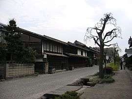
- Unno-shuku, a post station on the Hokkoku Kaidō
Notable people
- Raiden Tameemon (1767–1825), sumo wrestler
- Keiichi Tsuchiya (born 1956), racing driver
References
- ↑ "東御 1981-2010年". Japan Meteorological Agency. Retrieved October 18, 2011.
- ↑ "Company Overview." Nissin Kogyo. Retrieved on March 30, 2018.
- ↑ "Escolas Brasileiras Homologadas no Japão" (Archive). Embassy of Brazil in Tokyo. February 7, 2008. Retrieved on October 13, 2015.
- ↑ "Escolas Brasileiras Homologadas no Japão" (Archive). Embassy of Brazil in Tokyo. Retrieved on October 13, 2015. "2. Nagano Nippaku Gakuen (antigo Colégio Pitágoras)(Minowa) Obs: Em processo de homologação, devido à alteração do nome e do mantenedor"
- ↑ http://www.sister-cities.org/icrc/directory/usa/OR
External links

- Official website

| Core city | |
|---|---|
| Special city | |
| Cities | |
| Districts | |