Scarborough—Rouge River
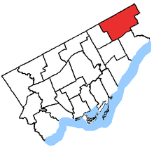 Scarborough—Rouge River in relation to the other Toronto ridings | |
| Defunct federal electoral district | |
| Legislature | House of Commons |
| District created | 1987 |
| District abolished | 2013 |
| First contested | 1988 |
| Last contested | 2011 |
| District webpage | profile, map |
| Demographics | |
| Population (2011)[1] | 135,102 |
| Electors (2011) | 85,505 |
| Area (km²)[2] | 51.17 |
| Census divisions | Toronto |
| Census subdivisions | Toronto |
.png)
Scarborough—Rouge River was a federal electoral district in Ontario, Canada, that has been represented in the House of Commons of Canada between 1988 and 2015. However, as of the Fall 2015 federal election, part of this riding has been combined with the south-western part of the old riding Pickering—Scarborough East.
The riding covered the northeast part of the Scarborough part of Toronto. It stretched from Highway 401 in the south to Steeles Avenue in the north. In the east it ended at the border with Pickering and in the west at Midland north of Finch and Brimley south of Finch.
Scarborough—Rouge River has the highest percentage of visible minorities in all electoral districts (89.7%)[3] and the lowest percentage of White Caucasians (10.1%).[4][5] Chinese make up 30.8%, South Asian 32.8% (all South Asian countries), Black 10.7%, White 8.7% Tamil is the mother tongue for 13.2% of the population,[6] which is the highest such percentage for that language among all ridings; likewise for Tamil as a home language (10.5%).[7] 13.6% of the population is Hindu, the highest in Canada.[8]
In the 2011 federal election, the NDP were elected for the first time. The riding was redistributed to Scarborough North and Scarborough—Rouge Park with new elected MPs as of the 2015 federal election.
Geography
Scarborough—Rouge River consists of the part of the City of Toronto bounded on the north and east by the city limits, on the west by Midland Avenue, and on the south by a line drawn from the east city limit west along Finch Avenue East, south along Meadowvale Road, west along Sheppard Avenue East, south along Morningside Avenue, west along Highway 401, north along Brimley Road, and west along Finch Avenue East to Midland Avenue.
History
The riding was created in 1987 from part of York—Scarborough riding.
It initially consisted of the part of the City of Scarborough. It was bounded on the north and east by the city limits, and on the south and west by a line drawn southwest from the eastern city limit along Highway 401 and Kingston Road, west along Highland Creek, north along Morningside Avenue, west along Ellesmere Road and north along the Canadian National Railway line to the northern city limit.
In 1996, it was redefined to be bounded on the north and east by the city limits, on the west by the Canadian National Railway situated immediately west of Midland Avenue, and on the south by a line drawn from west to east along Highway 401, north along Conlins Road, and east along Sheppard Avenue East and Twyn Rivers Drive to the east city limits.
In 2003, it was given its current boundaries as described above.
Following the 2012 federal electoral boundaries redistribution, the riding was split between Scarborough North and Scarborough—Rouge Park.
Members of Parliament
This riding has elected the following Members of Parliament:
| Parliament | Years | Member | Party | |
|---|---|---|---|---|
| Scarborough—Rouge River Riding created from York—Scarborough |
||||
| 34th | 1988–1993 | Derek Lee | Liberal | |
| 35th | 1993–1997 | |||
| 36th | 1997–2000 | |||
| 37th | 2000–2004 | |||
| 38th | 2004–2006 | |||
| 39th | 2006–2008 | |||
| 40th | 2008–2011 | |||
| 41st | 2011–2015 | Rathika Sitsabaiesan | New Democratic | |
| Riding dissolved into Scarborough—Rouge Park and Scarborough North |
||||
Election results
| Canadian federal election, 2011 | ||||||||
|---|---|---|---|---|---|---|---|---|
| Party | Candidate | Votes | % | ±% | Expenditures | |||
| New Democratic | Rathika Sitsabaiesan | 18,935 | 40.6 | +26.0 | $55,192.59 | |||
| Conservative | Marlene Gallyot | 13,935 | 29.9 | +7.4 | ||||
| Liberal | Rana Sarkar | 12,699 | 27.2 | -31.0 | ||||
| Green | George Singh | 684 | 1.5 | -2.4 | ||||
| Independent | Mark Balack | 357 | 0.8 | – | ||||
| Total valid votes/Expense limit | 46,610 | 100.0 | ||||||
| Total rejected ballots | 221 | 0.5 | – | |||||
| Turnout | 46,831 | 56.2 | – | |||||
| Eligible voters | 83,285 | – | – | |||||
| Canadian federal election, 2008 | ||||||||
|---|---|---|---|---|---|---|---|---|
| Party | Candidate | Votes | % | ±% | Expenditures | |||
| Liberal | Derek Lee | 23,716 | 58.2 | -7.8 | $62,814 | |||
| Conservative | Jerry Bance | 9,160 | 22.5 | +2.0 | $76,083 | |||
| New Democratic | Ryan Sloan | 5,954 | 14.6 | +3.8 | $1,836 | |||
| Green | Attila Nagy | 1,567 | 3.9 | +2.3 | $388 | |||
| Libertarian | Alan Mercer | 331 | 0.8 | – | $2,661 | |||
| Total valid votes/Expense limit | 40,728 | 100.0 | $88,438 | |||||
| Canadian federal election, 2006 | ||||||||
|---|---|---|---|---|---|---|---|---|
| Party | Candidate | Votes | % | ±% | ||||
| Liberal | Derek Lee | 30,281 | 66.0 | +8.1 | ||||
| Conservative | Jerry Bance | 9,426 | 20.5 | +7.2 | ||||
| New Democratic | Andrew Brett | 4,973 | 10.8 | +1.5 | ||||
| Green | Serge Abbat | 756 | 1.6 | +0.1 | ||||
| Independent | Yaqoob Khan | 467 | 1.0 | |||||
| Total valid votes | 45,903 | 100.0 | ||||||
| Canadian federal election, 2004 | ||||||||
|---|---|---|---|---|---|---|---|---|
| Party | Candidate | Votes | % | ±% | ||||
| Liberal | Derek Lee | 22,564 | 57.9 | -21.2 | ||||
| Independent | Raymond Cho | 6,962 | 17.9 | |||||
| Conservative | Tony Backhurst | 5,184 | 13.3 | -2.7 | ||||
| New Democratic | Fauzia Khan | 3,635 | 9.3 | +4.4 | ||||
| Green | Kathryn Holloway | 610 | 1.5 | |||||
| Total valid votes | 38,955 | 100.0 | ||||||
Note: Conservative vote is compared to the total of the Canadian Alliance vote and Progressive Conservative vote in 2000 election.
| Canadian federal election, 2000 | ||||||||
|---|---|---|---|---|---|---|---|---|
| Party | Candidate | Votes | % | ±% | ||||
| Liberal | Derek Lee | 28,669 | 79.1 | +4.3 | ||||
| Alliance | Kaiser Suleman | 3,237 | 8.9 | +0.8 | ||||
| Progressive Conservative | Alan Shumak | 2,566 | 7.1 | -4.3 | ||||
| New Democratic | Paulette Senior | 1,793 | 4.9 | 0.0 | ||||
| Total valid votes | 36,265 | 100.0 | ||||||
Note: Canadian Alliance vote is compared to the Reform vote in 1997 election.
| Canadian federal election, 1997 | ||||||||
|---|---|---|---|---|---|---|---|---|
| Party | Candidate | Votes | % | ±% | ||||
| Liberal | Derek Lee | 28,636 | 74.8 | +8.7 | ||||
| Progressive Conservative | Joe Li | 4,364 | 11.4 | -0.2 | ||||
| Reform | Ronald Bounds | 3,102 | 8.1 | -8.7 | ||||
| New Democratic | Pedram Moallemian | 1,874 | 4.9 | +2.1 | ||||
| Natural Law | Loucas Café | 170 | 0.4 | 0.0 | ||||
| Canadian Action | Steven Vaughan | 139 | 0.4 | |||||
| Total valid votes | 38,285 | 100.0 | ||||||
| Canadian federal election, 1993 | ||||||||
|---|---|---|---|---|---|---|---|---|
| Party | Candidate | Votes | % | ±% | ||||
| Liberal | Derek Lee | 31,582 | 66.1 | +19.0 | ||||
| Reform | Lee Saunders | 8,048 | 16.9 | |||||
| Progressive Conservative | Paul Ng | 5,524 | 11.6 | -26.0 | ||||
| New Democratic | Orrin Benn | 1,330 | 2.8 | -10.8 | ||||
| Libertarian | David Kenny | 364 | 0.8 | -0.3 | ||||
| Independent | Gulam Mohamed | 353 | 0.7 | |||||
| National | Chai Kalevar | 270 | 0.6 | |||||
| Natural Law | Loucas Café | 224 | 0.5 | |||||
| Abolitionist | Eric Brewer | 64 | 0.1 | |||||
| Total valid votes | 47,759 | 100.0 | ||||||
| Canadian federal election, 1988 | ||||||||
|---|---|---|---|---|---|---|---|---|
| Party | Candidate | Votes | % | |||||
| Liberal | Derek Lee | 22,767 | 47.1 | |||||
| Progressive Conservative | Doug Boswell | 18,171 | 37.6 | |||||
| New Democratic | Raymond Cho | 6,589 | 13.6 | |||||
| Libertarian | Simon Harvey | 513 | 1.1 | |||||
| Green | Lois James | 286 | 0.6 | |||||
| Total valid votes | 48,326 | 100.0 | ||||||
See also
References
- "(Code 35083) Census Profile". 2011 census. Statistics Canada. 2012. Retrieved 2011-03-03.
- Riding history from the Library of Parliament
- 2011 results from Elections Canada
- Campaign expense data from Elections Canada
Notes
- ↑ Statistics Canada: 2012
- ↑ Statistics Canada: 2012
- ↑ "2006 Census of Canada: Topic-based tabulations | Federal Electoral District (FED) Profile, 2006 Census". 2.statcan.gc.ca. Retrieved 2012-11-19.
- ↑ Aboriginals make up 0.2% of the population
- ↑ "Archived copy". Archived from the original on 2013-12-24. Retrieved 2014-01-25.
- ↑ "2011 Census of Canada: Topic-based tabulations | Detailed Mother Tongue (232), Knowledge of Official Languages (5), Age Groups (17A) and Sex (3) for the Population Excluding Institutional Residents of Canada, Provinces, Territories and Federal Electoral Districts (2003 Representation Order), 2011 Census". 2.statcan.gc.ca. Retrieved 2012-11-19.
- ↑ "First Official Language Spoken (7), Detailed Language Spoken Most Often at Home (232), Age Groups (17A) and Sex (3) for the Population Excluding Institutional Residents of Canada, Provinces, Territories and Federal Electoral Districts (2003 Representation Order), 2011 Census". 2.statcan.gc.ca. Retrieved 2012-11-19.
- ↑ "Religion (13) and Age Groups (8) for Population, for Canada, Provinces, Territories and Federal Electoral Districts (2003 Representation Order), 2001 Census - 20% Sample Data". 2.statcan.gc.ca. Retrieved 2012-11-20.