Pickering, Ontario
| Pickering | |
|---|---|
| City (lower-tier) | |
| City of Pickering | |
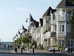 Nautical Village on Lake Ontario | |
| Nickname(s): P-Town,PK | |
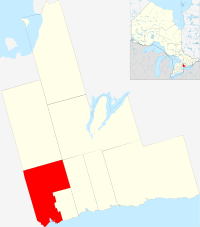 Pickering's location in Durham Region | |
 Pickering Pickering's location in Canada  Pickering Pickering (Ontario) | |
| Coordinates: 43°50′22″N 79°4′53″W / 43.83944°N 79.08139°W | |
| Country |
|
| Province |
|
| Region | Durham (York County 1811-1852 and Ontario County 1852-1974) |
| Established |
1811 (township) 1974 (town) 2000 (city) |
| Government | |
| • Mayor | David Ryan |
| • Governing body | Pickering City Council |
| • MP | Jennifer O'Connell (Pickering—Uxbridge) |
| • MPP |
Tracy MacCharles (Pickering—Scarborough East) Joe Dickson (Ajax—Pickering) |
| Area[1] | |
| • Total | 231.59 km2 (89.42 sq mi) |
| Elevation | 83.8 m (274.9 ft) |
| Population (2016)[1] | |
| • Total | 91,771 (Ranked 58th) |
| • Density | 383.1/km2 (992/sq mi) |
| Time zone | UTC−5 (Eastern (EST)) |
| • Summer (DST) | UTC−4 (Eastern (EDT)) |
| Forward Sortation Area | L1V to L1Y |
| Area code(s) | 905 / 289 / 365 |
| Highways |
|
| Website | pickering.ca |
Pickering (2016 population 91,771[1]) is a city located in Southern Ontario, Canada, immediately east of Toronto in Durham Region. It was settled by primarily ethnic British colonists, starting in the 1770s. Many of the smaller rural communities have been preserved and function as provincially significant historic sites and museums.[2]
History
Early period
This was Aboriginal territory for thousands of years. The Wyandot (called the Huron by Europeans), who spoke an Iroquoian language, were the historic people living here in the 15th century. Archeological remains of a large village have been found here, known as the Draper Site.[3] Later, the Wyandot moved northwest to Georgian Bay, where they established their historic homeland. There they encountered French explorers in the early 17th century, followed by missionaries and fur traders.
The first recorded history of this area was made in 1669, when French Jesuit missionary François de Salignac de la Mothe-Fénelon noted reaching what he called the Seneca (more likely Onondaga) village of Gandatsetiagon, on the shores of Frenchman's Bay (for whom it would be named for). The Onondaga (and the Seneca) were among the Five Tribes of the Iroquois Confederacy. The Onondaga (and other Iroquois) generally occupied territory to the south and west of Lakes Ontario and Erie in present-day New York, extending into Pennsylvania and the Ohio Valley, where they maintained hunting grounds. (The Seneca were located farther west, near Seneca Lake among the Finger Lakes. Fenelon wintered at the village and started missionary work with this people.[4])
European settlement
The British took over Canada following defeat of the French in the Seven Years' War, known in the Colonial America as the French and Indian War. They likely completed survey of the township about 1776; British colonial settlers were steadily migrating into the area from eastern areas of Canada.[5] The town was named after Pickering, North Yorkshire.[6]
In the 1813 census, Pickering had 180 residents —40 more than neighbouring Scarborough. A large influx of Quaker immigrants from the eastern United States arrived in the early 1810s.[7] The main thoroughfare at this time was the Kingston Road, which cut through the south of the township on its way from York (now Toronto) east to Kingston.
Pickering was represented in the Mackenzie Rebellion of 1837. One of the leaders, Peter Matthews, had formerly been one of the most prominent members of the community.[8]
Twentieth century
In 1941, the southeastern portion of the township became the independent town of Ajax. Ontario County, Ontario became Durham Region in 1974, and some of the town lines were modified. As a result, one of the population centres of the original township, Pickering Village, became part of Ajax, along with its secondary school.
Geography
Toronto, Markham, and Rouge Park border Pickering on the west; Ajax borders Pickering on the east; and Lake Ontario forms Pickering's southern boundary.[9][10]
Communities
The southern part of the city is mainly suburban, with industrial areas restricted to the area around Pickering Nuclear Generating Station. Most of the suburban areas were built as subdivisions after World War II, starting in the area around Frenchman's Bay. Prior to the war, the few suburban areas in the township were the communities of Dunbarton, Fairport Beach, Liverpool Market, and Rouge Hill. Squires Beach, located by the lakeshore in the southeast part of the city, is now a ghost town.
The northern part of the municipality is mainly rural, primarily used for agricultural purposes. However, a number of residential developments are found in this area, and the locally controversial Seaton area also falls within this part of the city. The primary rural communities in Pickering are Claremont, Brougham, and Whitevale; a number of smaller communities exist throughout northern Pickering such as Greenwood. John Diefenbaker, a Prime Minister of Canada, lived in Greenwood for a number of years.[11][12] The abandoned ghost town of Altona is located there. Cherrywood, another hamlet in Pickering,[13] is one of the few areas that are protected within the Greenbelt.[14][15] The communities of Kinsale in the northeast and Green River on the York-Durham town line are other small communities in Pickering with a population between 50-100 people. Most of these communities were founded in the 1700s and 1800s and have churches and historic estates that have been restored through government funding.[2] Dixie is a small rural community situated in rural Pickering, with more contemporary buildings.[16] Additionally, the film industry has been very active in communities such as Whitevale from the 1980s to the present (2017) due to the quality of the historical buildings and untouched nature of the landscape. The television shows Hannibal (2013-2015) Suits (2011-present), and American Gods (2017) have filmed extensively in Whitevale and in other locations in Pickering.[17]
Nautical Village is located at Frenchman's Bay and features entertainment, a playground, a boardwalk, restaurants, shops and an art gallery.
 Cherrywood
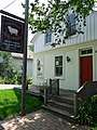 Whitevale Craftworks Store
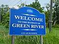 Green River
Demographics
| Historical populations | ||
|---|---|---|
| Year | Pop. | ±% |
| 1813 | 180 | — |
| 1981 | 37,754 | +20874.4% |
| 1991 | 68,831 | +82.3% |
| 1996 | 78,989 | +14.8% |
| 2001 | 87,139 | +10.3% |
| 2006 | 87,838 | +0.8% |
| 2011 | 88,721 | +1.0% |
| 2016 | 91,771 | +3.4% |
Pickering has experienced rapid growth in the post-war period in the second half of the twentieth century. Toronto's continuing growth led to more people moving into Pickering. Between 1996 and 2001, the municipality experienced a growth rate of 10.3 percent (78,989 people to 87,139). Population growth has slowed considerably in recent years, growing only slightly between the 2001 and 2016 census.
The low population growth is mainly due to the city's development restrictions on land in the northern portion of its area, as they tried to contain sprawl. Negotiations are ongoing to permit development in this area. Consequently, the city has estimated that by 2031, Pickering will be home to 190,000 residents.[18] The province of Ontario has designated Pickering as one of two municipalities in Durham Region that are urban growth centres, planned to receive more development and population.
According to the 2016 Census, English is the mother tongue of 76.7% of the population, followed by Urdu (2.4%), Tagalog (Pilipino, Filipino) (1.7%), Tamil (1.6%), Italian (1.3%), and Farsi (1.3%). reflecting 20th century and later immigration.
| Visible minority and Aboriginal population[19][20][21] | |||||||
|---|---|---|---|---|---|---|---|
| Population group | Population (2016) | % of total population (2016) | Population (2011) | % of total population (2011) | Population (2006) | % of total population (2006) | |
| White | 50,875 | 55.9% | 55,940 | 63.6% | 60,075 | 68.8% | |
| Visible minority group | South Asian | 13,820 | 15.2% | 9,690 | 11% | 7,940 | 9.1% |
| Chinese | 2,455 | 2.7% | 2,025 | 2.3% | 1,800 | 2.1% | |
| Black | 9,810 | 10.8% | 10,050 | 11.4% | 8,845 | 10.1% | |
| Filipino | 3,410 | 3.7% | 2,910 | 3.3% | 2,715 | 3.1% | |
| Latin American | 1,135 | 1.2% | 785 | 0.9% | 655 | 0.7% | |
| Arab | 1,520 | 1.7% | 835 | 0.9% | 610 | 0.7% | |
| Southeast Asian | 400 | 0.4% | 625 | 0.7% | 310 | 0.4% | |
| West Asian | 1,580 | 1.7% | 830 | 0.9% | 800 | 0.9% | |
| Korean | 295 | 0.3% | 285 | 0.3% | 310 | 0.4% | |
| Japanese | 310 | 0.3% | 255 | 0.3% | 375 | 0.4% | |
| Visible minority, n.i.e. | 2,285 | 2.5% | 1,435 | 1.6% | 1,040 | 1.2% | |
| Multiple visible minorities | 2,030 | 2.2% | 1,410 | 1.6% | 1,275 | 1.5% | |
| Total visible minority population | 39,050 | 42.9% | 31,130 | 35.4% | 26,685 | 30.5% | |
| Aboriginal group | First Nations | 550 | 0.6% | 565 | 0.6% | 370 | 0.4% |
| Métis | 460 | 0.5% | 215 | 0.2% | 195 | 0.2% | |
| Inuit | 35 | 0.1% | 0 | 0% | 10 | 0% | |
| Aboriginal, n.i.e. | 10 | 0% | 60 | 0.1% | 15 | 0% | |
| Multiple Aboriginal identities | 20 | 0% | 0 | 0% | 10 | 0% | |
| Total Aboriginal population | 1,070 | 1.2% | 850 | 1% | 600 | 0.7% | |
| Total population | 90,995 | 100% | 87,920 | 100% | 87,360 | 100% | |
Economy
Pickering is home to the Pickering Nuclear Generating Station, an eight-reactor facility with a capacity of 4,120 megawatts. The first station, Pickering A, opened with four reactors in 1971. Ontario Power Generation, the plants' operator, is the largest single employer in the city. In 2001, the wind-powered OPG 7 Commemorative Turbine was opened on the generating station site. The nuclear power plant is expected to start decommissioning in 2024.[22]
A number of manufacturers are also located in the city. Major employers include Yorkville Sound (audio equipment), the Canadian headquarters of Purdue Pharma (pharmaceuticals and health & beauty products), Hubbell Canada (electrical equipment), PSB Speakers - Lenbrook (stereo equipment) and Eco-Tec Inc. (industrial water purification and chemical recovery systems).
Pickering is a founding member of the Durham Strategic Energy Alliance or DSEA. The nucleus of the DSEA is primarily Pickering businesses, such as Ontario Power Generation, Veridian, Siemens/Trench, Tetra Tech WEI, AECL, Intellimeter, Areva and Eco-Tec Inc.
The city is the location of the head office of the Municipal Property Assessment Corporation. MPAC performs value assessment for property tax purposes for all municipalities in Ontario. In 2012 Search Engine People, Canada's largest Internet-marketing company, moved to Pickering's downtown.
In 2006, Profit magazine recognized Pickering as one of the top 10 cities in Canada for growing a business.
In 2013, the Region of Durham released its Business Count (Employment Survey), which indicated that Pickering has the most jobs amongst Durham Region municipalities, with 29,000+ positions. This figure represents a near 1/3 ratio of jobs to residents.
With the implementation of Seaton and downtown intensification, the Province of Ontario's planning sees the additional creation of 40,000 new jobs for Pickering over the next two decades.
Pickering has planned a downtown intensification program which includes new condominium developments around the Pickering GO station and Pickering Town Centre.[23][24] The enclosed pedestrian bridge over 14 lanes of highway 401 was also a recent development that has contributed to Pickering's push for greater downtown intensification.[25][26] Durham Live in south Pickering received approval for construction in 2017, and will include a water park, film studio, five star hotel, performing arts theater and possibly a casino.[27][28]
Mall
Pickering Town Centre is a two-story mall located in Pickering
Government
The city council consists of a mayor, three regional councillors, and three city councillors. The mayor and regional councillors sit on the council and also represent the city at Durham Regional Council. The city councillors sit on city council only. Pickering is divided into three wards, with one city councillor and one regional councillor representing each ward.
The current mayor, Dave Ryan, has held the mayoralty since 2003.
Infrastructure
Transportation
Transit service began in Pickering with the Bay Shores dial-a-bus, which began in 1970-1973. In 2001 Pickering Transit merged with former Ajax Transit to form the Ajax-Pickering Transit Authority (APTA). In 2006, the regional transit system Durham Region Transit took over operations in the Durham Regional Municipality.
The Pickering GO station offers public rail transit on an east-west axis. In 2012, Pickering's landmark bridge opened - connecting the Pickering GO station to the City's downtown core.
Durham Regional Roads serve the city, north and south. To find more about Durham Regional Roads, go to this link: Durham Regional Roads . Ontario Highway 401 runs near the south end of Pickering and Ontario Highway 407 ETR runs through the mid-north of the City.
A new airport is scheduled to be built and be operational by 2027. It will be built alongside lands for the future Rouge National Park.[29]
Emergency services
Police services in Pickering are provided by the Durham Regional Police from a division office located in the eastern section of the city. Officers from this location also patrol Ajax. Pickering Fire Services operates from four stations with a force of all full-time firefighters. Claremont Fire Hall is now fully staffed by full-time firefighters 24 hours a day, seven days a week. Ambulance/emergency medical services are provided by Durham Region.
Education
Pickering is served by the Durham District School Board, the Durham Catholic District School Board, the Conseil scolaire Viamonde and the Conseil scolaire de district catholique Centre-Sud. As of early 2007, the public board operates 17 elementary schools and two secondary schools, Dunbarton High School and Pine Ridge Secondary School (Pickering High School was previously located in Pickering, but was transferred to Ajax when the city boundaries were changed). The Catholic board runs eight elementary schools and one secondary school, Saint Mary Catholic Secondary School. The French public school board operates École Ronald-Marion, which serves both elementary and secondary students.
Blaisdale Montessori School, a private school chain, has several locations throughout Pickering serving children from preschool age to grade 8. There is also a private elementary and junior high school there called Montessori Learning Centre. Also serving the Durham Region is Durham Secondary Academy and Middle School, an inspected private high school and middle school for grades 5 to 12.
In September 2012, the Durham College/Centennial College Joint Learning Site opened at the north terminus of the pedestrian bridge. The Joint Learning Site offers primarily graduate certificate programs, with a number of complementary courses and classes. At the time of its opening, it was the only public post-secondary institution in the Province of Ontario with a direct connection to public transit.
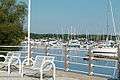 Boats and benches by Frenchman's Bay by Millennium Square
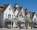 Trees in blossom in the springtime in the Nautical Village
 Wind Turbine and Pickering Nuclear Plant from Beachfront Park
 St. Isaac Jogues Church on Finch Avenue
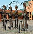 Pickering Pioneer Family by Andreas Drenters
Notable people
- Alan Haskvitz, National Teacher's Hall of Fame educator
- Andy Andreoff, NHL player
- Sheri Kershaw, Canadian musician, singer and songwriter
- Andrea Lewis, singer, actor and songwriter
- Beverly Thomson, co-host of CTV's Canada AM
- Bree Williamson, actress best known for her role as Jessica Buchanan on soap opera One Life to Live
- Cory Joseph, NBA player for the Indiana Pacers
- Craig Hutchison, Olympic swimmer
- Dale Goldhawk, journalist and consumer rights advocate
- Daniel David Palmer, the founder of chiropractic
- Denis T. O'Connor, former Roman Catholic archbishop of Toronto
- Ernie Coombs, children's entertainer, better known as Mr. Dressup
- Glenn Clark, former National Lacrosse League player and former head coach of the Toronto Rock
- Glenn Healy, former NHL goalie, member of 1994 Stanley Cup Champion New York Rangers
- Ilona Duczynska, Polish-Hungarian communist revolutionary, active in Hungary, Austria, England and Canada
- Jaime Peters, professional soccer player who plays midfield for Ipswich Town in the United Kingdom
- Karl Polanyi, professor of economics at Columbia University and author of The Great Transformation
- Kristen Holden-Ried, actor
- Laura Creavalle, Guyanese-born Canadian/American professional bodybuilder
- Neil Young, rock singer-songwriter, spent part of his early years in Pickering, living on Brock Road
- Nikkita Holder, Olympic track and field athlete
- Paul Peschisolido, professional soccer player who played in England as a striker and was the Manager of Burton Albion F.C.
- Perdita Felicien, Olympic track and field athlete
- Sarah Slean, singer
- Sean Avery, former NHL forward
- Shawn Mendes, singer who gained popularity through Vine
- Shelley-Ann Brown, Olympic silver-medalist
- Spider Jones, former professional boxer, media/radio personality, currently with CFRB radio
- Tyler Stewart, Barenaked Ladies drummer/singer
- Yannick Carter, Canadian Football League linebacker and special teamer for the Hamilton Tiger-Cats
In popular culture
Film
- The 1957 CBC/Hollywood production of the classic television show Hawkeye and the Last of the Mohicans was filmed in Pickering. A farm at the corner of Valley Farm Rd. and 3rd Concession, owned by Arthur Gottlieb, was the setting for the 25-episode series.
- The 1979 film The Black Stallion (film) was shot at a farm on Sideline 34 in north Pickering near Altona.
- The Canadian television show Paradise Falls' first season was filmed in the village of Whitevale, as was David Cronenberg's film The Dead Zone.
- The 1994 comedy The Ref with Denis Leary and Kevin Spacey was filmed in part at Port Pickering Marina, on Frenchman's Bay.
- The 1995 family/adventure film Salt Water Moose, starring Timothy Dalton and Lolita Davidovitch, was filmed in and around Frenchman's Bay.
- The 1998 comedy/action film The Big Hit with Mark Wahlberg, Lou Diamond Phillips, Avery Brooks, Christina Applegate and Elliott Gould, was filmed in part in Pickering near Petticoat Creek.
- The 2003 two-part mini-series Lives of the Saints, based on Nino Ricci's award-winning trilogy co-starring Sophia Loren, filmed scenes on a farm just north of Pickering.
- Pickering Museum Village has been used as a setting in Road to Avonlea, Little Men, and the films Anne of Green Gables and Lantern Hill.
- The final scene in Boondock Saints 2: All Saints' Day was filmed in Pickering.
See also
Literature
- Wood, William Robertson (1911). Past years in Pickering : sketches of the history of the community. Retrieved at the website "Our Roots - Nos Racines", University of Calgary / Université Laval.[30]
References
- 1 2 3 "Pickering, City Ontario (Census Subdivision)". Census Profile, Canada 2011 Census. Statistics Canada. 8 February 2012. Retrieved 2012-02-24.
- 1 2 https://www.pickering.ca/en/discovering/resources/CulturalMapPickeringApril2014.pdf
- ↑ James F. Pendergast, "The Confusing Identities Attributed to Stadacona and Hochelaga", Journal of Canadian Studies, Winter 1998, pp. 3–4, accessed Feb 3, 2010.
- ↑ Wood 1911, p. 11.
- ↑ Wood 1911, p. 17.
- ↑ Alan Rayburn. Place Names of Ontario. University of Toronto Press. p. 270. ISBN 9780802072078.
- ↑ Wood 1911, p. 18.
- ↑ Wood 1911, p. 27.
- ↑ Calis, Kristen (17 June 2016). "More protections for Rouge Park in Toronto, Pickering, but Province still hasn't handed over its land". durhamregion.com. Retrieved 21 March 2018.
- ↑ "Waterfront Trail". www.pickering.ca. Retrieved 21 March 2018.
- ↑ "Biography – DIEFENBAKER, JOHN GEORGE – Volume XX (1971-1980) – Dictionary of Canadian Biography". biographi.ca. Retrieved 21 March 2018.
- ↑ "Home". www.greenwoodrecassociation.com. Retrieved 21 March 2018.
- ↑ "The Hamlet of Cherrywood" (PDF).
- ↑ "Bill 135, Greenbelt Act, 2005". www.ontla.on.ca.
- ↑ "Detailed Mapping of the Greenbelt Plan Area (2005)". www.mah.gov.on.ca. Retrieved 21 March 2018.
- ↑ "Google Maps". Google Maps. Retrieved 21 March 2018.
- ↑ "Film Pickering". www.pickering.ca. Retrieved 21 March 2018.
- ↑ "City of Pickering Community Profile" (PDF). City of Pickering. 2012. Retrieved 2013-03-02.
- ↑ , Aboriginal Population Profile from the 2006 Census, Statistics Canada - Census Subdivision
- ↑ , Community Profiles from the 2006 Census, Statistics Canada - Census Subdivision
- ↑ , National Household Survey (NHS) Profile, 2011
- ↑ "Ontario Power Generation - Pickering Nuclear". www.opg.com. Retrieved 21 March 2018.
- ↑ https://www.pickering.ca/en/cityhall/downtownintensificationprogram.asp
- ↑ "Downtown Pickering Intensification Study - Urban Strategies". urbanstrategies.com. Retrieved 21 March 2018.
- ↑ Calis, Kristen (22 March 2017). "Pickering has big plans for a downtown". durhamregion.com. Retrieved 21 March 2018.
- ↑ "Pedestrian Bridge". www.pickering.ca. Retrieved 21 March 2018.
- ↑ "The Apostolopoulos family's plan to Vegas-ify Pickering, Ont". canadianbusiness.com. 26 November 2015. Retrieved 21 March 2018.
- ↑ Calis, Kristen (19 July 2017). "Ontario Municipal Board OK's plans for Durham Live in Pickering". durhamregion.com. Retrieved 21 March 2018.
- ↑ "Pickering airport announcement blindsides province and locals". The Star. Toronto. 2013-06-11.
- ↑ Info at ourroots.ca
External links
| Wikimedia Commons has media related to Pickering, Ontario. |
| Wikivoyage has a travel guide for Pickering (Ontario). |
Places adjacent to Pickering, Ontario | |
|---|---|
Largest city: Toronto | ||
| Regions | 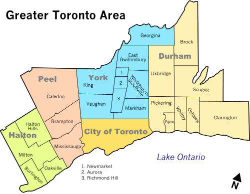 | |
| Cities | ||
| Towns | ||
| Townships and municipalities | ||