Utsira
| Utsira kommune | |||
|---|---|---|---|
| Municipality | |||
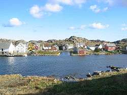 View of the Utsira harbor | |||
| |||
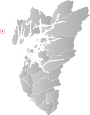 Utsira within Rogaland | |||
| Coordinates: 59°18′26″N 04°53′10″E / 59.30722°N 4.88611°ECoordinates: 59°18′26″N 04°53′10″E / 59.30722°N 4.88611°E | |||
| Country | Norway | ||
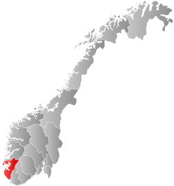
| County | Rogaland | ||
| District | Haugaland | ||
| Administrative centre | Utsira | ||
| Government | |||
| • Mayor (2012) | Marte Eide Klovning (Ap) | ||
| Area | |||
| • Total | 6.33 km2 (2.44 sq mi) | ||
| • Land | 6.30 km2 (2.43 sq mi) | ||
| • Water | 0.03 km2 (0.01 sq mi) | ||
| Area rank | #421 in Norway | ||
| Population (2017) | |||
| • Total | 201 | ||
| • Rank | #422 in Norway | ||
| • Density | 31.9/km2 (83/sq mi) | ||
| • Change (10 years) | -6.1% | ||
| Demonym(s) | Sirabu[1] | ||
| Time zone | UTC+01:00 (CET) | ||
| • Summer (DST) | UTC+02:00 (CEST) | ||
| ISO 3166 code | NO-1151 | ||
| Official language form | Neutral | ||
| Website |
www | ||

Utsira [ˈutsɪɾɑ] is the smallest municipality of Norway. The island municipality is located in northwestern Rogaland county, just off the western coast of Norway. Utsira is part of the traditional district of Haugaland.
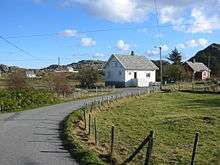
The municipality consists of the main island of Utsira as well as several small, uninhabited outlying islands. Utsira is located in the North Sea, about 18 kilometres (11 miles) west of the town of Haugesund. All of the 206 residents (as of 2015) live on the main island of Utsira, where the administrative centre and Utsira Church is located.
The 6-square-kilometre (2.3 sq mi) municipality is the 421st largest by area out of the 422 municipalities in Norway, making it the second smallest municipality after the nearby island municipality of Kvitsøy. Utsira is the 422nd most populous municipality in Norway with a population of 201, making it the smallest municipality in Norway by population. The municipality's population density is 31.9 inhabitants per square kilometre (83/sq mi) and its population has decreased by 6.1% over the last decade.[2]
General information

The municipality of Utsira was established on 1 July 1924 when it was separated from the municipality of Torvastad. Initially, Utsira had 414 residents. The municipal borders have not changed since that time.[3]
Name
The municipality was named after the island of Utsira which makes up the vast majority of the municipality. The Old Norse forms of the island's name was just Síri (nominative) or Síra (genitive). The first element ut was added in the 16th century (ut means "out" or "offshore"; compare the "Out Skerries" in Shetland).
The inhabitants still call the island Sira (leaving off the ut prefix) and an inhabitant of the municipality is called a sirabu. The meaning of the name Sira is unknown (maybe "strong stream"). (Sira is also the name of the border river between Rogaland and Vest-Agder counties.)
The Norwegian language has had several spelling reforms during the 19th and 20th centuries. Before 1875, the name was written "Udsire", from 1875–1924 it was spelled "Utsire", and since 1925 it has used the spelling "Utsira".[4]
Coat of arms
The coat of arms, granted on 23 July 1982, represents the light beams emerging from the local Utsira Lighthouse. The lighthouse was founded in 1844 and is one of the main landmarks on the municipality.[5]
Churches
The Church of Norway has one parish (sokn) within the municipality of Utsira. It is part of the Haugaland deanery in the Diocese of Stavanger.
| Parish (Sokn) | Church Name | Location of the Church | Year Built |
|---|---|---|---|
| Utsira | Utsira Church | Utsira | 1785 |
Transportation
The island municipality is only accessible by boat. There are roads on the island. A car ferry, operated by Rutebåten Utsira runs four round-trips per day connecting the island to the town of Haugesund on the mainland. The trip takes about 70 minutes each way. There are ferry docks on the north and south side of the island.
Government
All municipalities in Norway, including Utsira, are responsible for primary education (through 10th grade), outpatient health services, senior citizen services, unemployment and other social services, zoning, economic development, and municipal roads. The municipality is governed by a municipal council of elected representatives, which in turn elect a mayor.
Municipal council
The municipal council (Kommunestyre) of Utsira is made up of 11 representatives that are elected to four year terms. Currently, the party breakdown is as follows:[6]
| Party Name | Name in Norwegian | Number of representatives | |
|---|---|---|---|
| Local Lists | Lokale lister | 11 | |
| Total number of members: | 11 | ||
History
There are remains from the Stone Age on the island. It has been populated since that time. Historically, the island was governed by Torvastad, based on the mainland, but on 1 July 1924 the island was separated and it was established as a separate municipality. At that time, a new municipal council was to be elected. It was intended that the twelve men on the interim council would be elected, but the official list of candidates listed eleven women and a man. This was not known to even the people involved until the day of the election and by then it was too late. Despite a legal challenge the twelve were elected and Aasa Helgesen, the local midwife, was elected the first Mayor of Utsira and the first female mayor in Norway. Helgesen was a successful Mayor until 1928.[7]
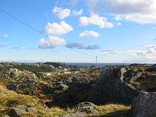
In 2004, Norsk Hydro installed a combined wind-hydrogen utility on Utsira. It is a full scale pilot project for energy self-sufficiency for a remote community. In periods when there is surplus wind energy, the excess power will be used for generating hydrogen by electrolysis. The hydrogen is stored, and is available for power generation in periods where there is little wind. Additional to this an energy storing flywheel exists to help out when for a short time more power is needed.
Climate
| Climate data for Utsira fyr 1981–2010 | |||||||||||||
|---|---|---|---|---|---|---|---|---|---|---|---|---|---|
| Month | Jan | Feb | Mar | Apr | May | Jun | Jul | Aug | Sep | Oct | Nov | Dec | Year |
| Record high °C (°F) | 10 (50) |
10 (50) |
14.8 (58.6) |
21.2 (70.2) |
23 (73) |
26.5 (79.7) |
29.3 (84.7) |
27 (81) |
23.3 (73.9) |
16.4 (61.5) |
12.8 (55) |
10.6 (51.1) |
29.3 (84.7) |
| Mean maximum °C (°F) | 7.8 (46) |
7.2 (45) |
8 (46) |
13 (55) |
17.8 (64) |
19.1 (66.4) |
21.4 (70.5) |
21 (70) |
17.9 (64.2) |
14.1 (57.4) |
10.7 (51.3) |
8.9 (48) |
21.4 (70.5) |
| Average high °C (°F) | 4.6 (40.3) |
4 (39) |
4.9 (40.8) |
7.5 (45.5) |
11.3 (52.3) |
13.8 (56.8) |
16.2 (61.2) |
16.5 (61.7) |
14.1 (57.4) |
10.8 (51.4) |
7.6 (45.7) |
5.6 (42.1) |
9.7 (49.5) |
| Daily mean °C (°F) | 3.2 (37.8) |
2.5 (36.5) |
3.2 (37.8) |
5.4 (41.7) |
8.8 (47.8) |
11.6 (52.9) |
14 (57) |
14.6 (58.3) |
12.4 (54.3) |
9.5 (49.1) |
6.3 (43.3) |
4.2 (39.6) |
8 (46.3) |
| Average low °C (°F) | 1.5 (34.7) |
0.9 (33.6) |
1.6 (34.9) |
3.6 (38.5) |
6.9 (44.4) |
9.7 (49.5) |
12.3 (54.1) |
12.9 (55.2) |
10.9 (51.6) |
7.9 (46.2) |
4.6 (40.3) |
2.5 (36.5) |
6.3 (43.3) |
| Mean minimum °C (°F) | −3.3 (26.1) |
−3.4 (25.9) |
−2.4 (27.7) |
−0.2 (31.6) |
3.1 (37.6) |
6.8 (44.2) |
9.5 (49.1) |
10 (50) |
7.3 (45.1) |
3.7 (38.7) |
0 (32) |
−2.4 (27.7) |
−3.4 (25.9) |
| Record low °C (°F) | −13.1 (8.4) |
−10.4 (13.3) |
−6.8 (19.8) |
−3.1 (26.4) |
−1.4 (29.5) |
4 (39) |
6.8 (44.2) |
8 (46) |
4.1 (39.4) |
0 (32) |
−6.2 (20.8) |
−6.5 (20.3) |
−13.1 (8.4) |
| Average precipitation mm (inches) | 129 (5.08) |
91 (3.58) |
99 (3.9) |
64 (2.52) |
55 (2.17) |
58 (2.28) |
77 (3.03) |
115 (4.53) |
121 (4.76) |
154 (6.06) |
141 (5.55) |
119 (4.69) |
1,223 (48.15) |
| Source: Norwegian Meteorological Institute (eKlima) | |||||||||||||
Shipping forecast
Utsira (under the spelling Utsire) gives its name to "North Utsire" and "South Utsire", two of the sea areas of the British Shipping Forecast.
Attractions
Utsira Lighthouse, the highest lighthouse light in Norway, at 78.2 metres (257 ft) AMSL, resides at Utsira.
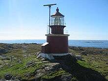 View of Utsira Lighthouse
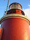 Lighthouse tower
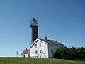 Tower and keeper's house
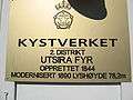 Utsira lighthouse sign
Birding
Utsira is known as the best birding site in Norway. There have been 317 different species recorded on Utsira, of which 23 are new to Norway.
References
- ↑ "Navn på steder og personer: Innbyggjarnamn" (in Norwegian). Språkrådet. Retrieved 2015-12-01.
- ↑ Statistisk sentralbyrå (2017). "Table: 06913: Population 1 January and population changes during the calendar year (M)" (in Norwegian). Retrieved 2017-11-04.
- ↑ Jukvam, Dag (1999). "Historisk oversikt over endringer i kommune- og fylkesinndelingen" (PDF) (in Norwegian). Statistisk sentralbyrå.
- ↑ Store norske leksikon. "Utsira" (in Norwegian). Retrieved 2015-10-22.
- ↑ "Civic heraldry of Norway - Norske Kommunevåpen". Heraldry of the World. Retrieved 2015-10-22.
- ↑ "Table: 04813: Members of the local councils, by party/electoral list at the Municipal Council election (M)" (in Norwegian). Statistics Norway. 2015.
- ↑ Baastad, Siri (15 December 1999). "Jordmor Helgesens "skjørteregime"". Kommunal Rapport (in Norwegian). Retrieved 2014-02-20.
External links


- Municipal fact sheet from Statistics Norway (in Norwegian)
- Municipality web site (in Norwegian)
- Map
- Birding on Utsira (in Norwegian)