Semans, Saskatchewan
| Semans | |
|---|---|
| Village | |
 Semans  Semans | |
| Coordinates: 51°14′N 104°14′W / 51.24°N 104.24°W | |
| Country | Canada |
| Province | Saskatchewan |
| Region | Saskatchewan |
| Census division | 10 |
| Rural Municipality | Mount Hope |
| Post office Founded | 1908-10-12 |
| Incorporated (Village) | December 14, 1908 |
| Government | |
| • Mayor | Duane Linford |
| • Administrator | Ashley Greenshields |
| • Governing body | Semans Village Council |
| Area | |
| • Total | 1.14 km2 (0.44 sq mi) |
| Elevation | 558 m (1,831 ft) |
| Population (2011)[1] | |
| • Total | 204 |
| • Density | 178.3/km2 (462/sq mi) |
| Time zone | UTC-6 (CST) |
| Postal code | S0A 3S0 |
| Area code(s) | 306 |
| Highways | Highway 15 |
| Website | Official Website Semans, Saskatchewan |
| [2][3] | |
Semans is a small agricultural village in Mount Hope No. 279, Saskatchewan, Canada. The population was 196 at the 2016 Canada Census. The village is located approximately 125 km north of Regina and 195 km south east of Saskatoon.
History
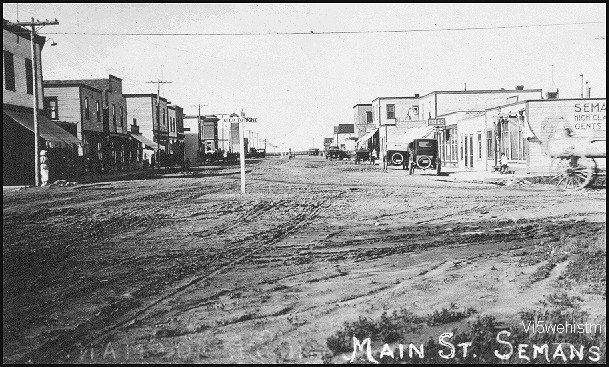
Semans celebrated 100 years as a village with a centennial anniversary homecoming on July 2008. Settlers first homesteaded in the Semans area as early as 1904. Semans, named for the wife of a railroad official, was one in the alphabetical sequence of towns on the Grand Trunk Railway line between Winnipeg, Manitoba and Saskatoon, Saskatchewan. A picture of the first station shows the spelling as "Semons". The first sports day was held on July 1, 1908. The railroad station and first grain elevator were built by the fall of 1908. In a little more than a year, local businesses could supply almost all necessary commodities and the population was 48 people. The first open air rink was in use by 1907. On October 28, 1908, the Semans Board of Trade sent correspondence regarding the organization of Semans under the Village Act of 1908. A petition was sent on November 4, 1908, signed by the businesses. Semans was established December 14, 1908.
Demographics
Semans has a population of 267 (according to Canada 2001 Census), with an estimated rural population of 750. In 2006, Semans had a population of 195 living in 137 dwellings, a -27.0% decrease from 2001. The village has a land area of 1.18 km2 (0.46 sq mi) and a population density of 164.7/km2 (427/sq mi).[4]
| Canada census – Semans, Saskatchewan community profile | |||
|---|---|---|---|
| 2016 | 2011 | 2006 | |
| Population: | 196 (-3.9% from 2011) | 204 (-4.6% from 2006) | 137 (-27.0% from 2001) |
| Land area: | 1.14 km2 (0.44 sq mi) | 1.14 km2 (0.44 sq mi) | 1.18 km2 (0.46 sq mi) |
| Population density: | 171.3/km2 (444/sq mi) | 178.3/km2 (462/sq mi) | 164.7/km2 (427/sq mi) |
| Median age: | 55.9 (M: 56.5, F: 55.6) | 54.2 (M: 54.0, F: 54.3) | 55.2 (M: 55.5, F: 54.8) |
| Total private dwellings: | 137 | 134 | 137 |
| Median household income: | |||
| References: 2016[5] 2011[6] 2006[7] earlier[8] | |||
Climate
| Climate data for Semans | |||||||||||||
|---|---|---|---|---|---|---|---|---|---|---|---|---|---|
| Month | Jan | Feb | Mar | Apr | May | Jun | Jul | Aug | Sep | Oct | Nov | Dec | Year |
| Record high °C (°F) | 7 (45) |
12.8 (55) |
20.5 (68.9) |
32.8 (91) |
37.8 (100) |
40 (104) |
42.2 (108) |
41.1 (106) |
35.6 (96.1) |
31.7 (89.1) |
21.1 (70) |
13.3 (55.9) |
42.2 (108) |
| Average high °C (°F) | −11.5 (11.3) |
−8.5 (16.7) |
−0.9 (30.4) |
10.4 (50.7) |
18.5 (65.3) |
22.7 (72.9) |
24.8 (76.6) |
24.3 (75.7) |
17.5 (63.5) |
10.5 (50.9) |
−1.8 (28.8) |
−9.7 (14.5) |
8 (46) |
| Daily mean °C (°F) | −16.8 (1.8) |
−13.7 (7.3) |
−5.8 (21.6) |
4.4 (39.9) |
11.8 (53.2) |
16.2 (61.2) |
18.2 (64.8) |
17.4 (63.3) |
11.1 (52) |
4.5 (40.1) |
−6.3 (20.7) |
−14.6 (5.7) |
2.2 (36) |
| Average low °C (°F) | −22.1 (−7.8) |
−18.8 (−1.8) |
−10.6 (12.9) |
−1.7 (28.9) |
5 (41) |
9.7 (49.5) |
11.5 (52.7) |
10.5 (50.9) |
4.6 (40.3) |
−1.6 (29.1) |
−10.7 (12.7) |
−19.5 (−3.1) |
−3.6 (25.5) |
| Record low °C (°F) | −44.4 (−47.9) |
−45 (−49) |
−38.9 (−38) |
−28.9 (−20) |
−12.2 (10) |
−5 (23) |
−1.1 (30) |
−5 (23) |
−13.9 (7) |
−23.5 (−10.3) |
−33.5 (−28.3) |
−43.5 (−46.3) |
−45 (−49) |
| Average precipitation mm (inches) | 20.6 (0.811) |
15.1 (0.594) |
17.3 (0.681) |
21.2 (0.835) |
46.7 (1.839) |
67.8 (2.669) |
74.3 (2.925) |
45.4 (1.787) |
35.5 (1.398) |
22.2 (0.874) |
19 (0.75) |
26.2 (1.031) |
411.3 (16.193) |
| Source: Environment Canada[9] | |||||||||||||
Notable people
- Gordon MacMurchy, MLA for Last Mountain and Member of the Saskatchewan Order of Merit
- Sherwood Bassin, hockey executive in Ontario Hockey League and the Canadian National junior team
See also
References
- ↑ "2011 Community Profiles". Statistics Canada. Government of Canada. Retrieved 2014-08-21.
- ↑ National Archives, Archivia Net. "Post Offices and Postmasters". Retrieved 2014-08-21.
- ↑ Government of Saskatchewan, MRD Home. "Municipal Directory System". Retrieved 2014-08-21.
- ↑ Statistics Canada. "Canada 2006 Census: Semans - Community Profile". Retrieved 2010-09-17.
- ↑ "2016 Community Profiles". Canada 2016 Census. Statistics Canada. February 21, 2017. Retrieved 2018-03-11.
- ↑ "2011 Community Profiles". Canada 2011 Census. Statistics Canada. July 5, 2013. Retrieved 2018-03-11.
- ↑ "2006 Community Profiles". Canada 2006 Census. Statistics Canada. March 30, 2011. Retrieved 2012-08-10.
- ↑ "2001 Community Profiles". Canada 2001 Census. Statistics Canada. February 17, 2012.
- ↑ Environment Canada - Canadian Climate Normals 1971-2000—Canadian Climate Normals 1971–2000, accessed 22 December 2010