Ravenwood, Missouri
| Ravenwood, Missouri | |
|---|---|
| City | |
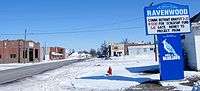 Ravenwood in 2009 | |
| Motto(s): Village in the Valley | |
 Location of Ravenwood, Missouri | |
| Coordinates: 40°21′9″N 94°40′17″W / 40.35250°N 94.67139°WCoordinates: 40°21′9″N 94°40′17″W / 40.35250°N 94.67139°W | |
| Country | United States |
| State | Missouri |
| County | Nodaway |
| Area[1] | |
| • Total | 0.27 sq mi (0.70 km2) |
| • Land | 0.27 sq mi (0.70 km2) |
| • Water | 0 sq mi (0 km2) |
| Elevation | 1,030 ft (314 m) |
| Population (2010)[2] | |
| • Total | 440 |
| • Estimate (2016)[3] | 404 |
| • Density | 1,600/sq mi (630/km2) |
| Time zone | UTC-6 (Central (CST)) |
| • Summer (DST) | UTC-5 (CDT) |
| ZIP code | 64479 |
| Area code(s) | 660 |
| FIPS code | 29-60716[4] |
| GNIS feature ID | 0725124[5] |
Ravenwood is a city in Nodaway County, Missouri, United States, near the Platte River. The population was 440 at the 2010 census, at which time it was a town.
History
Ravenwood was laid out in 1887 when the railroad was extended to that point.[6] The community has the name of the original owner of the land where the village now stands.[6] A post office called Ravenwood has been in operation since 1888.[7]
Geography
Ravenwood is located at 40°21′9″N 94°40′17″W / 40.35250°N 94.67139°W (40.352577, -94.671469).[8] According to the United States Census Bureau, the city has a total area of 0.27 square miles (0.70 km2), all land.[1]
Demographics
| Historical population | |||
|---|---|---|---|
| Census | Pop. | %± | |
| 1900 | 285 | — | |
| 1910 | 341 | 19.6% | |
| 1920 | 344 | 0.9% | |
| 1930 | 336 | −2.3% | |
| 1940 | 336 | 0.0% | |
| 1950 | 319 | −5.1% | |
| 1960 | 282 | −11.6% | |
| 1970 | 336 | 19.1% | |
| 1980 | 436 | 29.8% | |
| 1990 | 409 | −6.2% | |
| 2000 | 448 | 9.5% | |
| 2010 | 440 | −1.8% | |
| Est. 2016 | 404 | [3] | −8.2% |
| U.S. Decennial Census[9] | |||
2010 census
As of the census[2] of 2010, there were 440 people, 185 households, and 119 families residing in the city. The population density was 1,629.6 inhabitants per square mile (629.2/km2). There were 208 housing units at an average density of 770.4 per square mile (297.5/km2). The racial makeup of the city was 99.5% White, 0.2% African American, and 0.2% from two or more races. Hispanic or Latino of any race were 0.2% of the population.
There were 185 households of which 30.8% had children under the age of 18 living with them, 50.8% were married couples living together, 10.8% had a female householder with no husband present, 2.7% had a male householder with no wife present, and 35.7% were non-families. 30.3% of all households were made up of individuals and 14% had someone living alone who was 65 years of age or older. The average household size was 2.38 and the average family size was 2.97.
The median age in the city was 36.7 years. 26.1% of residents were under the age of 18; 7.1% were between the ages of 18 and 24; 24.6% were from 25 to 44; 27.8% were from 45 to 64; and 14.5% were 65 years of age or older. The gender makeup of the city was 47.5% male and 52.5% female.
2000 census
As of the census[4] of 2000, there were 448 people, 196 households, and 118 families residing in the town. The population density was 1,660.1 people per square mile (640.6/km²). There were 209 housing units at an average density of 774.5 per square mile (298.9/km²). The racial makeup of the town was 98.66% White, 0.22% Native American, 0.22% Asian, and 0.89% from two or more races.
There were 196 households out of which 29.6% had children under the age of 18 living with them, 50.0% were married couples living together, 6.6% had a female householder with no husband present, and 39.3% were non-families. 33.2% of all households were made up of individuals and 17.9% had someone living alone who was 65 years of age or older. The average household size was 2.29 and the average family size was 2.93.
In the town the population was spread out with 23.9% under the age of 18, 12.3% from 18 to 24, 25.4% from 25 to 44, 20.3% from 45 to 64, and 18.1% who were 65 years of age or older. The median age was 36 years. For every 100 females there were 93.1 males. For every 100 females age 18 and over, there were 89.4 males.
The median income for a household in the town was $31,250, and the median income for a family was $39,750. Males had a median income of $27,120 versus $18,750 for females. The per capita income for the town was $16,136. About 5.6% of families and 8.9% of the population were below the poverty line, including 8.0% of those under age 18 and 14.7% of those age 65 or over.
References
- 1 2 "US Gazetteer files 2010". United States Census Bureau. Archived from the original on 2012-01-24. Retrieved 2012-07-08.
- 1 2 "American FactFinder". United States Census Bureau. Retrieved 2012-07-08.
- 1 2 "Population and Housing Unit Estimates". Retrieved June 9, 2017.
- 1 2 "American FactFinder". United States Census Bureau. Retrieved 2008-01-31.
- ↑ "US Board on Geographic Names". United States Geological Survey. 2007-10-25. Retrieved 2008-01-31.
- 1 2 "Nodaway County Place Names, 1928–1945". The State Historical Society of Missouri. Archived from the original on June 24, 2016. Retrieved November 24, 2016.
- ↑ "Post Offices". Jim Forte Postal History. Retrieved 24 November 2016.
- ↑ "US Gazetteer files: 2010, 2000, and 1990". United States Census Bureau. 2011-02-12. Retrieved 2011-04-23.
- ↑ "Census of Population and Housing". Census.gov. Retrieved June 4, 2015.
Municipalities and communities of Nodaway County, Missouri, United States | ||
|---|---|---|
| Cities | 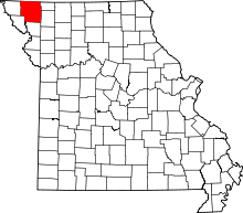 | |
| Villages | ||
| Townships | ||
| CDPs | ||
| Unincorporated communities | ||
| Ghost town | ||
