Conception, Missouri
| Conception | |
|---|---|
| Census-designated place | |
 Conception Location within the state of Missouri | |
| Coordinates: 40°14′32″N 94°41′1″W / 40.24222°N 94.68361°WCoordinates: 40°14′32″N 94°41′1″W / 40.24222°N 94.68361°W | |
| Country | United States |
| State | Missouri |
| County | Nodaway |
| Time zone | UTC-6 (Central (CST)) |
| • Summer (DST) | UTC-5 (CDT) |
Conception is a census-designated place in eastern Nodaway County, Missouri, United States.[1] It is located about eleven miles southeast of Maryville on U.S. Route 136. It is very near Conception Junction (which was the rail intersection). Conception is home to Conception Abbey.
History
Conception was originally built up chiefly by Irish Catholics.[2] The community was named for the Catholic dogma of Immaculate Conception.[3] A post office called Conception has been in operation since 1864.[4] Conception has frequently been noted on lists of unusual place names.[5]
References
- ↑ U.S. Geological Survey Geographic Names Information System: Conception, Missouri
- ↑ Moyer, Armond; Moyer, Winifred (1958). The origins of unusual place-names. Keystone Pub. Associates. p. 27.
- ↑ Eaton, David Wolfe (1917). How Missouri Counties, Towns and Streams Were Named. The State Historical Society of Missouri. p. 336.
- ↑ "Post Offices". Jim Forte Postal History. Retrieved 24 November 2016.
- ↑ Parker, Quentin (2010). Welcome to Horneytown, North Carolina, Population: 15: An insider's guide to 201 of the world's weirdest and wildest places. Adams Media. pp. ix.
Municipalities and communities of Nodaway County, Missouri, United States | ||
|---|---|---|
| Cities | 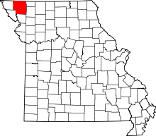 | |
| Villages | ||
| Townships | ||
| CDPs | ||
| Unincorporated communities | ||
| Ghost town | ||
This article is issued from
Wikipedia.
The text is licensed under Creative Commons - Attribution - Sharealike.
Additional terms may apply for the media files.