Ranong Province
| Ranong ระนอง | |||
|---|---|---|---|
| Province | |||
 | |||
| |||
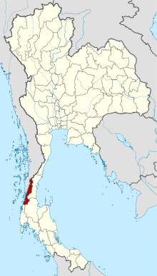 Map of Thailand highlighting Ranong Province | |||
| Country | Thailand | ||
| Capital | Ranong | ||
| Government | |||
| • Governor | Chatuphot Piyamputtra (since October 2016) | ||
| Area | |||
| • Total | 3,298.0 km2 (1,273.4 sq mi) | ||
| Area rank | Ranked 59th | ||
| Population (2014) | |||
| • Total | 177,089 | ||
| • Rank | Ranked 76th | ||
| • Density | 54/km2 (140/sq mi) | ||
| • Density rank | Ranked 71st | ||
| Time zone | UTC+7 (ICT) | ||
| ISO 3166 code | TH-85 | ||

Ranong (Thai: ระนอง, pronounced [ra.nɔːŋ] or [rá.nɔːŋ]) is one of Thailand's southern provinces (changwat), on the west coast along the Andaman Sea. It has the fewest inhabitants of all Thai provinces. Neighboring Ranong are (clockwise) Chumphon, Surat Thani, and Phang Nga. To the west, it borders Kawthaung, Tanintharyi, Myanmar.
Geography
Ranong is on the Kra Isthmus, a narrow strip of land, only 44 kilometres wide,[1] that connects Thailand with the Malay Peninsula, on the west of the Phuket mountain range. It has a long coast on the Andaman Sea. The province, together with Trat Province, is known for being one of the wettest places in Thailand, the rainy season lasting for about eight months.[2]
Ranong is the least populated province. Eighty percent of its area is covered by forests, and 67 percent is mountainous. In former years the major industry was tin mining, but most mines are now exhausted. White clay mining (for the production of porcelain) and fishing are now the main industries, along with rubber and cashew nuts.
The Ngao Mangrove Forest Research Centre, also known as the Ranong Biosphere Reserve, in the north of Kapoe District, covering 189,431 rai[1] (303.09 km2), was declared in 1997. It is the fourth biosphere reserve of Thailand, and the only one on the seacoast protecting mangrove forests. Khlong Nakha Wildlife Sanctuary is in the south of the province.
History
Ranong province once was a deputy city of Chumphon in Ayuthaya era (1350–1767).[3] It was a small, mountainous city that protected Chumphon from Burma. The population was very low until the discovery of tin. People from many cities and foreigners started to visit Ranong, to do tin business there.
Ranong was named after Lord Ranong. At the start of the Rattanakosin era (1781–present), there was a Chinese merchant named Kho Su Jiang. He was very wealthy. He bought all the tin business in Ranong and was appointed tax collector of Ranong by Lord Ranong.
In 1854, Lord Ranong died. King Mongkut, the King Rama IV, promoted Kho Su Jiang to Lord of Ranong, named "Pha Rattana Sedtee". Ranong always paid taxes to the capital and its income was increasing. So, in 1877, King Chulalongkorn, Rama V, elevated Ranong to provincial status.
Historians classify Ranong's importance into four sections, Tin city, border city, Khokotkra, and city for the king to rest.[4]
Tin city: Ranong held undiscovered natural resources and forest areas. After the discovery of tin in Ranong, development increased, as did the population. Roads were improved. Foreigners visited Ranong for trading. Ranong had high income and paid tax to the capital, which made the capital wealthier. This is one of reasons Ranong was promoted to a province.
Border city: There were two Burmese cities, Marid and Mariwan that once belonged to Thailand, but the Thai King ceded them to Britain to avert war. After Burma was freed from Britain Ranong became a border city next to Burma. Trading goods with Burmar brought development and income to Ranong and the country.
Khokotkra: is a name for the narrowest part of Thailand. Its breadth from east to west is only 44 kilometres. The French hoped to dig a canal. If successful, traveling from Europe to China would be easier because one would pass through Thailand, which was faster and cheaper, instead of circumnavigating Malaysia. Britain at that time owned the harbors of Singapore and Penang. They forced the suspension of the project. Thailand continued to find ways to dig the canal until the end of World War II. After that, Thailand signed the British-imposed treaty called "The Termination of The State of War Between Siam and Allies". It forbade Thailand from digging Khokotkra without British permission - a stipulation still in effect today.
A city for the king to rest: In the past many kings of Thailand visited Ranong. The first was King Chulalongkorn. In 1890, he stayed at Rattana Ransan palace for three nights. Now the palace is one of the landmarks in Ranong. King Phajadhipok, Rama VII, was the second to visit. The last were King Bhumibol Adulyadej, Rama IX, and Queen Sirikit Kitiyakara.
Symbols
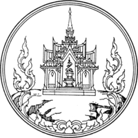
The provincial seal shows a castle on top of a hill, as an aide memoire that King Chulalongkorn (Rama V) once visited Ranong and stayed at the Ratana Rangsan Castle on top of the Niveskiri Hill. The number five refers to King Rama V; the castle is Ratana Rangsan Palace; the mountain is Niveshkiri; the royal tray refers to the people of Ranong.[5]
The provincial slogan is, "Kra Isthmus, mountain grass, cashew nut, mineral water stream, and real pearl of Ranong."[5]
The provincial tree is the Banaba (Lagerstroemia speciosa), and the provincial flower is the orchid Dendrobium formosum.
Administrative divisions
Ranong is divided into five districts (amphoe). These are further subdivided into 30 sub-districts (tambon) and 167 villages (muban). Ranong itself is the only town (thesaban mueang), and there are five more sub-district municipalities (thesaban tambon).
| Map | Number | Name | Thai |
|---|---|---|---|
 | |||
| 1 | Mueang Ranong | เมืองระนอง | |
| 2 | La-un | ละอุ่น | |
| 3 | Kapoe | กะเปอร์ | |
| 4 | Kra Buri | กระบุรี | |
| 5 | Suk Samran | สุขสำราญ |
Transportation
Phet Kasem Road (Thailand Route 4) runs through the city. Ranong Airport is about 24 kilometres (15 mi) south of town.
The Port Authority of Thailand operates the Ranong Port, which is Thailand's principal Indian Ocean port. In 2008, the Ranong human-smuggling incident resulted in 54 deaths.[6]
Tourism
Namtok Ngao National Park (อุทยานแห่งชาติน้ำตกหงาว) Covering a total area of approximately 417,500 rai (668 km2) it was declared a national park on 3 June 1999.[7]
Ko Chang (Ranong) (เกาะช้าง) island in tambon Ko Phayam. With an area of 18 square kilometres and 80 homes on the entire island. Cashew and para rubber plantations as well as coastal fisheries are the main industries.[8]
Laem Son National Park (อุทยานแห่งชาติแหลมสน) It covers a total area of 196,875 rai (31.5 hectares). It also includes islands in the Andaman Sea; namely, Ko Khangkhao and Mu Ko Kam.[9] Places of interest within the national park include:
- Hat Bang Ben (หาดบางเบน) is a long sandy beach shaded by pine trees where the national park headquarters is located.
- Hat Laem Son (หาดแหลมสน) is a white sandy beach approximately four kilometres next to Hat Bang Ben.
- Hat Praphat or Hat Hin Thung (หาดประพาส หรือ หาดหินทุ่ง) Similar to Hat Bang Ben, Hat Praphat is a large beach shaded by pine trees.
- Ko Khangkhao (เกาะค้างคาว) is an island with fine sandy beaches and a gravel beach known as Hat Hin Ngam in the north.
- Ko Kam Yai (เกาะกำใหญ่) is a scenic island with white sandy beaches.
- Ko Kam Nui (เกาะกำนุ้ย) is not far from Ko Kam Yai with beaches on one side and many other nearby islets.
 Laem Son National Park
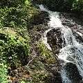 Namtok Chum Saeng, Kra Buri District
 Namtok Punyaban, Mueang Ranong District
References
- 1 2 Svasti, Pichaya (19 July 2018). "Another Pearl of the Andaman". Bangkok Post. Retrieved 19 July 2018.
- ↑ "Ranong". Tourism Authority of Thailand (TAT). Retrieved 26 May 2015.
- ↑ ประวัติเมืองระนอง,https://naranong.org/welcome/index.php/ranong
- ↑ ประวัติศาสตร์โบราณคดีจังหวัดระนอง, http://www.finearts.go.th/olddata/files/Ranong.pdf
- 1 2 "Symbol of Ranong". OSM Andamnan: The Office of Strategy Management for Southern Province Cluster. Retrieved 26 May 2015.
- ↑ "54 Burmese dead in trafficking horror". Phuket Gazette. April 10, 2008. Archived from the original on January 12, 2013. Retrieved September 29, 2018.
- ↑ "Namtok Ngao National Park". Department of National Parks (DNP) Thailand. Archived from the original on 26 May 2015. Retrieved 26 May 2015.
- ↑ "Koh Chang". Tourism Authority of Thailand (TAT). Retrieved 19 July 2018.
- ↑ "Laemson National Park". Department of National Parks (DNP) Thailand. Retrieved 26 May 2015.
External links

- Official website
- Ranong provincial map, coat of arms and postal stamp
| Wikimedia Commons has media related to Ranong Province. |
Places adjacent to Ranong Province | |
|---|---|