Nabha State
| Nabha State ਨਾਭਾ ਰਿਆਸਤ/ नाभा रियासत | ||||||
| Princely State | ||||||
| ||||||
| ||||||
 | ||||||
| Historical era | New Imperialism | |||||
| • | Established | 1763 | ||||
| • | Accession to India | 1947 | ||||
| Area | ||||||
| • | 1901 | 2,502 km2 (966 sq mi) | ||||
| Population | ||||||
| • | 1901 | 297,949 | ||||
| Density | 119.1 /km2 (308.4 /sq mi) | |||||
| Today part of | India | |||||


_(14597378638).jpg)
Nabha State,[1] with its capital at Nabha, was one of the Phulkian princely states of Punjab during the British Raj in India.[2]
History
Nabha was a state of Siddhu Jats founded by grandson of Chaudhary Phul Singh in 1755.[3]
- Phul Singh had six sons namely, 1.Tiloka 2.Ram Singh 3.Rudh 4.Chunu 5. Jhandu and 6.Takhtmal.
- Tiloka had two sons namely, 1. Gurudutta 2. Sukh Chain.
- Sukh Chain's descendants ruled Jind state
- Gurudatta's descendants ruled Nabha state.
- Gurudatta's only son was Surat Singh. Surat Singh died in 1742 prior to Gurudatta in 1744.
- Surat Singh had two sons 1. Hamir Singh (1755-1783 ) and 2. Kapur Singh.
- Hamir Singh's son Raja Jaswant Singh (1783-1840) became the ruler. He had two sons namely 1. Raja Devendra Singh and 2. Ranjit Singh.
- Raja Devendra Singh had two sons namely, 1. Raja Bharpur Singh and 2. Raja Bhagwan Singh.
- Raja Bharpur Singh died in 1863 prior to Raja Devendra Singh.
- Raja Bhagwan Singh ruled from 1864-1871. He had no son, so he adopted Raja Hira Singh (1871-1911).
- Raja Hira Singh ruled from 1871-1911. He was honoured with G.C.S.I. and G.C.I.I. titles by British. His only son was Maharaja Ripudaman Singh.
- Maharaja Ripudaman Singh (1911-1923) (1911-1923) or Gurcharan Singh, became ruler in 1912 after Raja Hira Singh.
- Maharaja Pratap Singh (1923-1995) born in 1919 was only son of Maharaja Ripudaman Singh.
The Mughals appointed his descendant Mehraj in 1526. This office became hereditary amongst his descendants until Phul, the Sikh ancestor of the dynasty, which came to rule over Patiala, Jind and Nabha[4] The state was established in 1763 after the capture of Sirhind by the Sikh Confederacy. With the capture of Sirhind, most of the old imperial province was divided amongst the Phulkian chiefs. The area around Amloh was taken by the chief of the Nabha — Hamir Singh.
In 1809, with the power of Ranjit Singh expanding, Nabha State fell under the protection of the East India Company. During the Indian rebellion of 1857 the state was loyal to its subsidiary alliance with the British and was granted territory as a reward.[5]
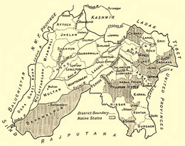
Its territories were scattered. One section, divided into twelve separate tracts, was interspersed among the territories of Patiala and Jind, in the east and south of the Punjab. The other section was in the extreme southeast of that province in Rewari and Bawal which the traitor ruler, Hira Singh, had got from the British for fighting against fellow Indian ruler of Jhajjar, Abdur Rehman, in the first war of independence in 1857.[2] The whole of the territories physically belonged to a plain, but they varied in character, from the great fertility of the Pawadh region to the semi-arid proximity of Rajputana desert.[2]
The state entered a period of prosperity under the rule of Hira Singh. The state had built a residence Nabha House in Delhi, also one Nabha House in pilgrimage town of Kurukshetra, situated opposite to the Sannihit Sarovar[6]
Dissolution
In 1947, with the British departure from India, the subsidiary alliance was dissolved and Nabha was briefly fully independent. Its ruler soon decided to sign an instrument of accession, acceding to the new Dominion of India, when the state was combined with other princely states into the Patiala and East Punjab States Union. It later became part of the Indian state of Punjab.
Rulers
Nabha State's rulers bore the title 'Maharaja' after 1911.[7]
Rajas
- 1755 – Dec 1783 Hamir Singh (d. 1783)
- Dec 1783 – 21 May 1840 Jashwant Singh (b. 1775 - d. 1840)
- Dec 1783 – 1790 Desu Kaur Sahiba (f) -Regent (d. 1790)
- 21 May 1840 – 18 Sep 1846 Devendra Singh (b. 1822 - d. 1865)
- 18 Sep 1846 – 9 Nov 1863 Bharpur Singh (b. 1840 - d. 1863)
- 18 Sep 1846 – Oct 1856 Rani Mai Chand Kaur (f) -Regent
- 9 Nov 1863 – 31 May 1871 Bhagwan Singh (b. 1842 - d. 1871)
- 31 May 1871 – 12 Dec 1911 Hira Singh (b. 1843 - d. 1911) (from 29 Jul 1879, Sir Hira Singh)
Maharajas
- 12 Dec 1911 – 24 Dec 1911 Sir Hira Singh (s.a.)
- 24 Dec 1911 – 19 Feb 1928 Ripudaman Singh (b. 1883 - d. 1942)
- 8 Jul 1923 – 19 Feb 1928 .... -Administrator
- 19 Feb 1928 – 15 Aug 1947 Pratap Singh (b. 1919 - d. 1995) (from 1 Jan 1946, Sir Pratap Singh)
- 19 Feb 1928 – 5 Mar 1941 Regents:
- - Charles McIvor Grant Ogilvie (acting, to Sep 1923)
- - Joseph Wilson-Johnston (b. 1876 - d. 1933)(Sep 1923 - to c.1928)
- - Diwan Gyan Nath (c.1928 - Nov 1939)
- - Edward Birkbeck Wakefield (b. 1903 - d. 1969) (from Nov 1939)
Demography
According to the 1901 census the state had a population of 297,949 and contained four towns and 488 villages. Its population at the previous two enumerations were: 282,756 (1891) and 261,824(1881).
Nabha was divided into three nizamats: Amloh and Bawal, with their headquarters at the town from which each is named; and Phul, with its headquarters at Dhanaula.[5]
More than 54 per cent of the population were Hindus, only 26 per cent being Sikhs — although Nabha was one of the principle Sikh states of the Punjab, the remainder of the population were Muslim.[8]
See also
References
- ↑ Imperial Gazetteer of India, v. 18, p. 271.
- 1 2 3

- ↑ [ The Rajas of the Punjab by Lepel H. Griffin/The History of the Nabha State, pp.417-]
- ↑ Royalark - Patiala
- 1 2 Nābha State - Imperial Gazetteer of India, v. 18, p. 264.
- ↑ "Nabha House, Kurukshetra". Haryana Tourism. Retrieved 2014-08-09.
- ↑ "Nabha History and Genealogy". Royal Ark.
- ↑ Nābha State - Imperial Gazetteer of India, v. 18, p. 265.
External links
