Kumharsain
| Kumarsain कुमारसैन | |
|---|---|
| Town | |
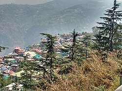 Kumarsain as seen from nearby village | |
 Kumarsain Location in Himachal Pradesh, India  Kumarsain Kumarsain (India) | |
| Coordinates: 31°19′05″N 77°26′46″E / 31.318145°N 77.446189°ECoordinates: 31°19′05″N 77°26′46″E / 31.318145°N 77.446189°E | |
| Country |
|
| State | Himachal Pradesh |
| District | Shimla |
| Elevation | 1,762 m (5,781 ft) |
| Population (2011) | |
| • Total | 5,461 |
| • Rank | 29 in HP |
| Languages | |
| • Official | Hindi |
| Time zone | UTC+5:30 (IST) |
| PIN | 172029 |
| Vehicle registration | HP-95 |
Kumharsain also known as Kumarsain or Kumarsan was a princely state of the British Raj, located in modern day Indian state of Himachal Pradesh. It was one of the several states of Punjab States Agency[1]. Kumarsain was a Tehsil until 2017 when it was made a sub-division of Shimla District.
Kumarsain was founded in the 11th century. It was occupied by Nepal from 1803 to 1816, and by British India from 1839 to 1840. The rulers of the state used the title of 'Rana'.
Kumarsain lies 1 km beside National Highway 5 (India) from Bharara village which is 18 km from Narkanda towards Rampur Bushahr. Kumarsain has many educational institutes like Govt. ITI (Industrial Training Institute) and Govt. Degree college. Many other departments and schools are rapildy increasing the population and developing growth of Kumarsain.
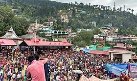
As many other places people of Kumarsain also celebrate their own fairs. Every year Bharara Mela is celebrated on 14th May in Bharara Village near Kumarsain and after every 3 years Mela Char Saala is celebrated in Kumarsain which is the most crowded and awaited fair in the area.
Kumarsain has an history of around 1000 years. It is one of the oldest settlements that are still being inhabitat. It is also one of the most literate town in Himachal Pradesh.
Geography
Kumarsain is located at 31°19′05″N 77°26′46″E / 31.318145°N 77.446189°E. It has an average elevation of 1,762 metres (5,781 ft). Kumarsain has an ideal climate and temperature throughout year. Kumarsain Town has many villages within its boundary namely Mateyog, Damali, Lathi, Bharara, Bai and Dethal.
Tourist attractions in Kumarsain include Narkanda, Kotgarh, Hatu peak, Tanijubbal Lake, Derthu peak, Kali Mata Temple Kacheri, Shilaroo Hockey Stadium and Oddi.
Government
Kumarsain was a Constituency of Himachal Pradesh Legislative Assembly and have a separate Election Seat until 2008 when it was merged into Theog constituency. Veteran Congress Minister Vidya Stokes was elected 2 times as MLA in 2003 [2] and 2007 [3] from Kumarsain. Kumarsain comes under Narkanda Block. As Kumarsain was given SDM Office, Narkanda was given Block Development Office and Kotgarh was given Forest Department Division Office by Himachal Pradesh Government. Kumarsain is 8th sub-division of Shimla District [4].
Govt. Departments in Kumarsain:
1. Himachal Pradesh Public Works Department (Division and Sub Division).
2. Himachal Pradesh State Electricity Board (Division and Sub division).
3. Irrigation and Public Health Department (Sub Division).
4. Women and Child Development Department (Child Development Project Officer).
5. Himachal Fire Services (Fire Post).
6. Tehsil Office (Tehsildar and Naib Tehsildar).
7. Sub Divisional Magistrate Office.
8. Himachal Pradesh Department of Labour and Employment (Sub Office - Employmemt Exchange).
9. Police Station (Station House Officer).
10. Civil Hospital (Block Medical Officer)
Demographics
As of 2011 India census[5], Kumarsain had a population of 5,461. Males constitute 52% of the population and females 48%. Kumarsain has an average literacy rate of 97.8%, much higher than the national average of 59.5% male literacy is 97%, and female literacy is 89%. In Kumarsain 11% of the population is under 14 years of age.
History
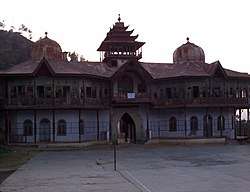
The Great Congress Leader Late. Jai Bihari Lal Khachi (former PWD minister of Himachal Pradesh) was from this town and in his honour there is Govt. school named after him in Kumarsain. Khachi was elected 4 times as MLA from Kumarsain Assembly seat in 1982, 1985 [6], 1993 and 1998 assembly elections. He died of heart attack in 2002, that time he was the sitting MLA of Kumarsain Constituency. Kumarsain's famous Hira Mahal which was pride of Kumarsain and served as the home to Ranas of this princely state, was burnt because of accidental fire that took place in the mahal in 2007.
Also the first apple tree grown in India was in the Kotgarh village in Kumarsain tehsil by Satyanand Stokes.
Transportation
Kumarsain has a bus station from where you can take routine local route buses or long route buses of HRTC to Kullu, Shimla, Chandigarh, Ambala, Haridwar, Delhi, Rampur Bushahr, Reckong Peo and many other places. Alternatively you can hire a taxi as 24 hours taxi service is also available in Kumarsain.
Ranas
Raja Kirat Singh founded Kumharsain Dominion in 11th century A.D.
- ???? - 1803 Kehar Singh (1st time)
- 1816 - 1839 Kehar Singh (2nd time)
- 1840 - 1858 Pritam Singh
- 1858 - 1874 Bhawani Singh
- 1874 - 1914 Hira Singh
- 24 August 1914 – 15 August 1947 Vidyadhar Singh (b. 1895 - d. ...)
Villages and Towns in Kumharsain Tehsil
Towns
1. Kumarsain
2. Narkanda
Villages
1 Ahar
2 Arot
3 Aur
4 Bagain
5 Bagthal
6 Bahli
7 Bai
8 Bakhlain
9 Balinda
10 Banahar
11 Banot
12 Bara Gaon
13 Barara
14 Bargal
15 Barogi
16 Barori
17 Barubagh
18 Batara
19 Batari
20 Baza
21 Bhalari
22 Bhanana
23 Bharari
24 Bharasa
25 Bhareri
26 Bhargaon
27 Bhuna
28 Bhuth
29 Bhutti
30 Chajol
31 Chala Nal
32 Chalan
33 Chamor
34 Chamyala
35 Charonta
36 Chekul
37 Chohan
38 Chopala
39 Churath
40 D.P.F. Nag kelo Saroga
41 D.P.F. Nagkelo
42 Dagrot
43 Dakolu
44 Dakoon
45 Dalan
46 Damaur
47 Daro
48 Dawala
49 Deeb
50 Deoridhar
51 Dethal
52 Devali Dhar
53 Dhala
54 Dhali
55 Dhanal
56 Dharuri
57 Dheongli
58 Dogri
59 Doja
60 Ganeog
61 Gharal
62 Ghareawat
63 Ghughvi
64 Gheti
65 Gonthla
66 Halyana
67 Hathiya
68 Jadoon
69 Jal
70 Jalti
71 Jangal Ahar
72 Jangal Dawala
73 Jangal Hatu
74 Jangal Havan
75 Jangal Jogsha
76 Jangal Madhawan
77 Jangal Marni
78 Jangal Nun-II
79 Janjeli
80 Jar
81 Jarol
82 Jhamol
83 Jhunjan
84 Jimu
85 Kacheri
86 Kalmu
87 Kanahr
88 Kanda-1
89 Kanda-2
90 Kandyali
91 Kangal
92 Karewati
93 Katheen
94 Kaunthru
95 Kehri
96 Kepu
97 Khaner
98 Khaneti
99 Khatkar
100 Khekhar
101 Kholwi
102 Khuhan
103 Kingal
104 Kirti
105 Kopri
106 Kot
107 Kotgarh
108 Koti
109 Kotla
110 Kowahra
111 Kufri
112 Kui
113 Lathi
114 Lauga
115 Luan
116 Madhawani
117 Madhuban
118 Mahawari
119 Maholi
120 Majrog
121 Malendi
122 Manan-1
123 Manan-2
124 Mandholi
125 Mangsu
126 Manu
127 Melan
128 Mogra
129 Mohan
130 Nag
131 Nagali
132 Nagraon
133 Nahal
134 Nahana
135 Nanjha
136 Naula
137 Nehri
138 Nun
139 Pamlai
140 Parashan
141 Pauchi
142 Pharal
142 Pharnal
144 Phirnu
145 Rahu
146 Reog
147 Rewali
148 Ropa
149 Sainj Paranu
150 Sakundi Chimla
151 Sapela
152 Sarahan
153 Saroga
154 Ser Dhar
155 Shalota
156 Shamthla
157 Shanad
158 Shathla
159 Shawat
160 Shehdari
161 Shela
162 Shelag
163 Shiwan
164 Talha
165 Tepri
166 Teshan
167 Thah
168 Thanu
169 Thinu
170 Tramli
171 Urshu
References
- ↑ John Hutchison and JP Vogel, History of Punjab Hill states; Lahore 1933
- ↑ "Himachal Pradesh legislative assembly election, 2003" (PDF). Retrieved 25 October 2013.
- ↑ "Himachal Pradesh legislative assembly election, 2007". Retrieved 25 October 2013.
- ↑ "Subdivisions & Block".
- ↑ "Census of India 2011: Data from the 2011 Census, including cities, villages and towns (Provisional)". Census Commission of India. Archived from the original on 2004-06-16. Retrieved 2008-11-01.
- ↑ "Himachal Pradesh legislative assembly election, 1985" (PDF). Retrieved 25 October 2013.
External links
- Rulers.org: Kumharsain
- Edited By