Phrae Province
| Phrae แพร่ | |||
|---|---|---|---|
| Province | |||
 | |||
| |||
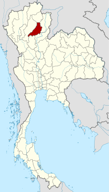 Map of Thailand highlighting Phrae Province | |||
| Country | Thailand | ||
| Capital | Phrae | ||
| Government | |||
| • Governor | Watthana Phutthichat (since October 2016) | ||
| Area | |||
| • Total | 6,538.6 km2 (2,524.6 sq mi) | ||
| Area rank | Ranked 32nd | ||
| Population (2014) | |||
| • Total | 454,083 | ||
| • Rank | Ranked 48th | ||
| • Density | 69/km2 (180/sq mi) | ||
| • Density rank | Ranked 57th | ||
| Time zone | UTC+7 (ICT) | ||
| ISO 3166 code | TH-54 | ||


Phrae (Thai: แพร่; pronounced [pʰrɛ̂ː]) is one of the northern provinces (changwat) of Thailand.[1] Neighboring provinces are (from north clockwise) Phayao, Nan, Uttaradit, Sukhothai, and Lampang.
Geography
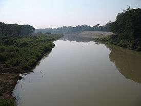
Phrae is in the valley of the Yom River. The Phi Pan Nam Range runs across the province from north to south in the west. The Phlueng Range is in the east.
History
The history of Phrae dates back to the Haripunchai kingdom of the Mon. It became part of the Lannathai Kingdom in 1443, when King Tilokaraj was on an expedition to capture Nan.
Symbols
Provincial seal: According to legend the two cities of Phrae and Nan were once ruled by brothers. When they met to divide the land between them the one from Phrae rode on a horse, the one from Nan on a buffalo to the meeting point on top of a mountain. Hence Phrae uses a horse in their seal, while Nan uses a buffalo. When the provincial government proposed the seal in 1940, the Fine Arts Department suggested adding a historic building to the seal in addition to the horse, thus it now has the stupa of Phra Tat Cho Hae on the back of the horse. This temple is about nine kilometers southeast of the city of Phrae.[2]
The provincial flower and tree is the Burmese Almondwood (Chukrasia tabularis).
Administrative divisions

The province is divided into eight districts (amphoe). These are further subdivided into 78 sub-districts (tambon) and 645 villages (muban).
Transportation
The main road through Phrae is Route 101, which begins in Nan to the north, passes through Phrae, and leads to Sawankhalok, Sukhothai, and finally Kamphaeng Phet.
Phrae Airport is a small airport in Mueang Mo, on the east side of town. It handles only domestic flights from Don Mueang (DMK).[3]
Tourism

Wiang Kosai National Park (อุทยานแห่งชาติเวียงโกศัย) contains two waterfalls, the Mae Koeng Luang (น้ำตกแม่เกิ๋งหลวง), and the Mae Koeng Noi (น้ำตกแม่เกิ๋งน้อย). Streams from the falls flow into the Yom River.
Tham Pha Nang Khoi Cave (ถ้ำผานางคอย). At the end of the cave is a stalagmite shaped like a woman holding a small child. In front of the Nang Koi (waiting woman) stone is a heart-shaped stalactite. They are the source of the legend of the love of a woman who waited for her lover until she turned to stone.[4]
References
- ↑ "Phrae". Tourism Authority of Thailand (TAT). Archived from the original on 26 April 2015. Retrieved 18 May 2015.
- ↑ "General Information". Phrae Province. Archived from the original on 18 June 2013. Retrieved 18 May 2015.
- ↑ "(PRH) Phrae Airport Overview". Flightstats. Retrieved 13 May 2015.
- ↑ Tham Pha Nang Khoi Archived January 15, 2011, at the Wayback Machine.
- ↑ "Mae Yom National Park". Department of National Parks (DNP) Thailand. Archived from the original on 21 January 2015. Retrieved 18 May 2015.
External links

| Wikimedia Commons has media related to Phrae Province. |
- Phrae Province website
- Phrae provincial map, coat of arms and postal stamp Archived October 6, 2010, at the Wayback Machine.
- Knowledge of Encyclopediathai Travel & Country Guides Welcome to Phrae Province
Places adjacent to Phrae Province | |
|---|---|
Coordinates: 18°8′42″N 100°8′26″E / 18.14500°N 100.14056°E