Wang Chin District
| Wang Chin วังชิ้น | |
|---|---|
| Amphoe | |
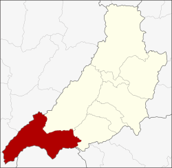 Amphoe location in Phrae Province | |
| Coordinates: 17°54′0″N 99°36′12″E / 17.90000°N 99.60333°ECoordinates: 17°54′0″N 99°36′12″E / 17.90000°N 99.60333°E | |
| Country | Thailand |
| Province | Phrae |
| Seat | Wang Chin |
| Area | |
| • Total | 1,216.96 km2 (469.87 sq mi) |
| Population (2005) | |
| • Total | 47,720 |
| • Density | 39.2/km2 (102/sq mi) |
| Time zone | UTC+7 (ICT) |
| Postal code | 54160 |
| Geocode | 5407 |
Wang Chin (Thai: วังชิ้น, pronounced [wāŋ t͡ɕʰín]) is a district (amphoe) in the southern part of Phrae Province, northern Thailand.
History
Originally the area of the district was part of Mueang Lampang District. In 1930 it was reassigned to Long District, Phrae Province. On 1 March 1939 the minor district (king amphoe) Wang Chin was established as a subordinate of Long District,[1] which was upgraded to a full district in 1958.[2]
Geography
Neighboring districts are (from the north clockwise) Long and Den Chai of Phrae Province, Si Satchanalai of Sukhothai Province, Thoen, Sop Prap, and Mae Tha of Lampang Province.
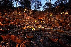
The Phi Pan Nam Mountains dominate the landscape of the district. The Wiang Kosai National Park is in it. There are columnar basalt formations in Mon Hin Kong (Thai: ม่อนหินกอง) in an area in the mountains near Na Phun, in this district.[3]
Administration
The district is divided into seven sub-districts (tambon), which are further subdivided into 77 villages (muban). Wang Chin is a township (thesaban tambon) and covers parts of tambon Wang Chin. There are a further seven tambon administrative organizations (TAO).
| No. | Name | Thai name | Villages | Pop. | |
|---|---|---|---|---|---|
| 1. | Wang Chin | วังชิ้น | 11 | 9,166 | |
| 2. | Saroi | สรอย | 11 | 6,565 | |
| 3. | Mae Pak | แม่ป้าก | 10 | 5,318 | |
| 4. | Na Phun | นาพูน | 11 | 7,713 | |
| 5. | Mae Phung | แม่พุง | 16 | 8,625 | |
| 6. | Pa Sak | ป่าสัก | 10 | 5,654 | |
| 7. | Mae Koeng | แม่เกิ๋ง | 8 | 4,679 |
References
- ↑ ประกาศกระทรวงมหาดไทย เรื่อง ตั้งกิ่งอำเภอวังขึ้น ขึ้นอำเภอลอง จังหวัดแพร่ (PDF). Royal Gazette (in Thai). 55 (0 ง): 3880. February 20, 1939.
- ↑ พระราชกฤษฎีกาจัดตั้งอำเภอกระสัง อำเภอกระนวน อำเภอบางกอกใหญ่ อำเภอขุนหาร อำเภอพนา อำเภอปากช่อง อำเภอวังเหนือ อำเภอวังชิ้น อำเภอแม่ทา อำเภอหนองหมู อำเภอสระแก้ว อำเภออมก๋อย อำเภอบางซ้าย อำเภอทับสะแก อำเภอบุณฑริก อำเภอลานสะกา อำเภอจอมบึง อำเภอท่ายาง อำเภอสามเงา อำเภอฟากท่า อำเภอบ้านเขว้า อำเภอชานุมาน อำเภอแม่พริก อำเภอท่าสองยาง อำเภอสะเมิง อำเภอหนองแขม อำเภอพระแสง พ.ศ. ๒๕๐๑ (PDF). Royal Gazette (in Thai). 75 (55 ก): 321–327. July 22, 1958.
- ↑ ม่อนเสาหินพิศวง Wonderful Mountain Of Colunnar
External links