Yom River
| Yom River | |
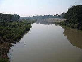 Yom River in Mueang Phrae District, Phrae Province | |
| Country | Thailand |
|---|---|
| Tributaries | |
| - right | Ngao River |
| Source | |
| - location | Bun Yuen village, Pong district, Phi Pan Nam Range, Phayao Province |
| - elevation | 347 m (1,138 ft) |
| Mouth | Nan River |
| - location | Chum Saeng district, Nakhon Sawan province |
| - elevation | 28 m (92 ft) |
| Length | 787 km (489 mi) |
| Basin | 24,047 km2 (9,285 sq mi) |
| Discharge | for Nakhon Sawan |
| - average | 103 m3/s (3,637 cu ft/s) |
| - max | 1,916 m3/s (67,663 cu ft/s) |
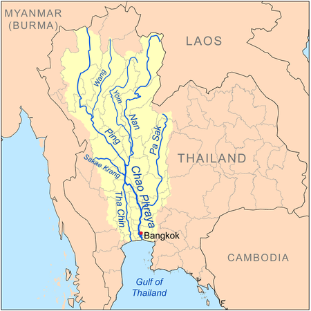 Map of the Chao Phraya River drainage basin showing the Yom River | |
The Yom River (Thai: แม่น้ำยม, RTGS: Maenam Yom, pronounced [mɛ̂ː.náːm jōm]) is a river in Thailand. It is the main tributary of the Nan River (which itself is a tributary of the Chao Phraya River). The Yom River has its source in the Phi Pan Nam Range in Pong District, Phayao Province. Leaving Phayao, it flows through Phrae and Sukhothai as the main water resource of both provinces before it joins the Nan River at Chum Saeng District, Nakhon Sawan Province.
Tributaries
Tributaries of the Yom include Nam Mae Phong, Ngao River, Nam Ngim, Huai Mae Sin, Nam Suat, Nam Pi, Mae Mok, Huai Mae Phuak, Mae Ramphan, Nam Mae Lai, Nam Khuan, and Nam Mae Kham Mi.
Yom Basin
The Yom river and its tributaries drain a total area of 24,047 square kilometres (9,285 sq mi) of land (called the Yom Basin) in the provinces of Sukhothai, Phitsanulok, Phichit, Phrae, and Lampang.[1] The Yom Basin is part of the Greater Nan Basin and the Chao Phraya Watershed.
A controversial large dam was planned on the Yom River in the central area of the Phi Pan Nam mountains in Kaeng Suea Ten in 1991 but the project was later abandoned.[2] The debate about the dam was opened again in 2011.[3] Currently a proposal is being debated to build two smaller dams on the Yom River in the area instead of the Kaeng Suea Ten mega-dam.[4]
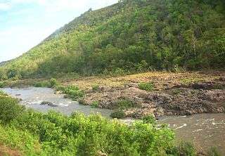 The Yom River and the Phi Pan Nam Range, Long District, Phrae Province |
Protected areas
The Yom River flows through Mae Yom National Park in Phrae Province.
References
External links
| Wikimedia Commons has media related to Yom River. |
- Living River Siam
- Bangkok Post - Living in the ugly shadow of the kaeng sua ten dam
- A Never-ending Story… Living with the Forest and Protection of the river fish
Coordinates: 19°23′24″N 100°27′18″E / 19.39000°N 100.45500°E