Prachuap Khiri Khan Province
| Prachuap Khiri Khan ประจวบคีรีขันธ์ | |||
|---|---|---|---|
| Province | |||
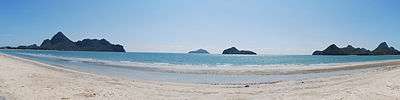
 Laem Sala Beach | |||
| |||
| Nickname(s): Prachuap | |||
 Map of Thailand highlighting Prachuap Khiri Khan Province | |||
| Country | Thailand | ||
| Capital | Prachuap Khiri Khan | ||
| Government | |||
| • Governor | Thawi Naritsirikun (since October 2015) | ||
| Area | |||
| • Total | 6,367 km2 (2,458 sq mi) | ||
| Area rank | Ranked 33rd | ||
| Population (2014) | |||
| • Total | 539,534[1] | ||
| • Rank | Ranked 51st | ||
| • Density rank | Ranked 58th | ||
| Time zone | UTC+7 (ICT) | ||
| ISO 3166 code | TH-77 | ||


Prachuap Khiri Khan (Thai: ประจวบคีรีขันธ์, pronounced [prā.t͡ɕùa̯p.kʰīː.rīː.kʰǎn]) is one of the western provinces (changwat) of Thailand. It is in the northern part of the Malay Peninsula, some 240 km (150 mi) south of Bangkok. Neighboring provinces are Phetchaburi to the north and Chumphon to the south. To the west it borders Tanintharyi Region of Myanmar.
Geography
Prachuap Khiri Khan covers an area of 6,367 square kilometres (2,458 sq mi).[2] The province is on the Kra Isthmus, the narrow land bridge connecting the Malay Peninsula with mainland Asia. The province has the narrowest part of Thailand, just 13 km (8.1 mi) from the Gulf of Thailand to the border with Myanmar in the Tenasserim Hills.[3] Geographically, Prachuap Khiri Khan is a moderate plain with elevations varying from sea level to 1,200 m (3,900 ft). The maximum elevations are found in the northeastern and central west regions, which make up approximately 30 percent of the province.
.
The long coast of the Gulf of Thailand has many sandy beaches. One of the best known, Hua Hin, has been a popular resort since King Prajadhipok (Rama VII) built a summer palace there. From the coast the land quickly rises into the Tenasserim Hills, the mountain chain that forms the border with Myanmar. Due to its narrow watershed, the rivers in the province are all small. The only one of significance is the Pranburi River in the north. Among the smaller rivers is the Khlong Kui.[4]
Khao Sam Roi Yot National Park was established in 1966 to protect Thailand's largest freshwater marshes. The park contains some mangrove forests and mudflats. Most of the marshes were converted into shrimp farms, despite being in a national park.
History
The city of Muang Na Rang was reconstructed in 1845, after it had been abandoned during the fall of the Ayutthaya Kingdom in 1767. The town was rebuilt at the mouth of the Ron River and renamed "Prachuap Khiri Khan", which means "city in the mountains".
King Mongkut gathered the people of three towns—Bang Nangrom, Kui Buri and Khlong Wan—and resettled them in the rebuilt city. At the same time, he renamed Koh Kong, a city on the opposite side of Gulf of Thailand, Prachanta Khiri Khet. Koh Kong is a now a province of Cambodia.
In 1868, King Mongkut invited foreign guests to the province to watch a solar eclipse he had predicted for 18 August. The dignitaries viewed it from an observation point in the marshes near Sam Roi Yot. He contracted malaria, of which he died on 1 October.
Prachuap became a seaside resort during the reign of King Rama V. In the reign of King Rama II, a new city was established at the mouth of the I Rom Canal known as Muang Bang Nang Rom.
At the beginning of World War II, Japanese troops invaded Thailand. On 8 December 1941, they struck first near the city of Prachuap Khiri Khan. After resisting the Japanese in the Battle of Prachuap Khiri Khan, after several hours the defenders were ordered to cease fire by the government in Bangkok.
Symbols
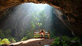
The provincial seal shows the Kuha Karuhas Pavilion, which was built when King Chulalongkorn (Rama V) visited the Praya Nakorn Cave (Sam Roi Yot District). Depicted behind the pavilion is the island of Ko Lak in Prachuap Bay, the historic center of administration.
The provincial tree as well as the provincial flower is the rayan or manilkara (Manilkara hexandra).
The provincial slogan is 'City of pure gold, delectable coconuts and pineapples, delightful beaches, mountain and caves, land of spiritual beauty'.
Administrative divisions

The province is divided into eight districts (amphoes). The districts are further subdivided into 48 communes or sub-districts (tambons) and 388 villages (mubans).
Transport
Air
Hua Hin Airport is in Hua Hin District. AirAsia serves the airport with a direct flight to Kuala Lumpur that commenced on 18 May 2018.[5]
Rail
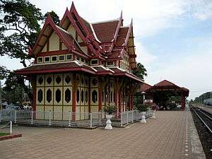
The railway in Prachuap Khiri Khan is on the southern route from Bangkok. There are five major stations in Prachuap Khiri Khan: Hua Hin Railway Station, Pran Buri Railway Station, Prachuap Khiri Khan Railway Station, Bang Saphan Yai Railway Station, and Bang Saphan Noi Railway Station.
Road
Prachuap is on Thailand Route 4 (Phetkasem Road), which links the central region with the south.
Tourism
Thailand's royal family and especially former kings were the first to set this location on the map as the original seashore destination in Thailand. The long white sandy beaches themselves are clean and pretty. Besides sunbathing snorkeling and swimming, visitors can also enjoy golf, spas, caves, peaks, waterfalls, shops, and nearby national parks.
References
- ↑ "1 Demographic, population and housing statistics; Number of Population from Registration by Age, Sex and Province: 2016". National Statistical Office (NSO). Retrieved 19 December 2017.
- ↑ Svasti, Pichaya (11 October 2018). "A place of gold". Bangkok Post (Life, Travel). Retrieved 11 October 2018.
- ↑ "ABOUT PRACHUAP KHIRI KHAN". Tourism Authority of Thailand (TAT). Retrieved 9 February 2017.
- ↑ Geography of Thailand Archived 2009-11-15 at the Wayback Machine.
- ↑ "Regular flights begin at Hua Hin airport". Bangkok Post. 18 May 2018. Retrieved 18 May 2018.
External links

| Wikimedia Commons has media related to Prachuap Khiri Khan. |
- Prachuap Khiri Khan provincial map, coat of arms and postal stamp
- Provincial website (Thai only)
- Kui Buri National Park, Khiri Khan Province
Places adjacent to Prachuap Khiri Khan Province | ||||||||||
|---|---|---|---|---|---|---|---|---|---|---|
| ||||||||||