Hua Hin District
| Hua Hin หัวหิน | |
|---|---|
| District | |
 Hua Hin | |
 District location in Prachuap Khiri Khan Province | |
| Coordinates: 12°34′7″N 99°57′28″E / 12.56861°N 99.95778°ECoordinates: 12°34′7″N 99°57′28″E / 12.56861°N 99.95778°E | |
| Country | Thailand |
| Province | Prachuap Khiri Khan |
| Area | |
| • Total | 838.9 km2 (323.9 sq mi) |
| Population (2017-12-31 est.) | |
| • Total | 63,091 |
| • Density | 101.44/km2 (262.7/sq mi) |
| Time zone | UTC+7 (ICT) |
| Postal code | 77110 |
| Geocode | 7707 |
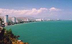
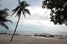
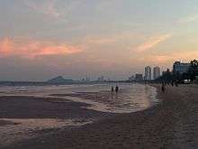
Hua Hin District (Thai: หัวหิน, IPA: [hǔə hǐn]) is one of eight districts (amphoe) of Prachuap Khiri Khan Province in the northern part of the Malay Peninsula in Thailand. Its seat of government, also named Hua Hin, is a beach resort town. The district's population was estimated at 63,091 in December 2017 by the Bureau of Registration Administration[1] in an area of 911 km2. By road, it is 199 km south-southwest of Bangkok.
History
In 1834, before the name Hua Hin was coined, some agricultural areas of Phetchaburi Province were hit by severe drought. A group of farmers moved south until they found a small village that had bright white sand and a row of rocks along the beach. They settled there and gave it the name Samore Riang (Samo Riang), which means 'rows of rocks'.
In 1921 the director of the state railway, Prince Purachatra, built the Railway Hotel close to the beach. Prince Krom Phra Naresworarit was the first member of the royal family to build a group of palaces at Ban Laem Hin, called Sukaves, and gave the beach next to his palace the name "Hua Hin". King Prajadhipok (Rama VII) liked the place so much that he built a summer palace there which was later named Klai Kang Won ('far from worries'). From 2004 until 2006 it was the full-time residence of King Bhumibol Adulyadej (Rama IX), until health issues forced him to return to Siriraj Hospital in Bangkok, where medical facilities and physicians were closer at hand.
In 1932 Hua Hin was part of Pran Buri District as a minor district (king amphoe). In 1949 Hua Hin became a separate district of Prachuap Khiri Khan.[2] After the building of Thailand's southern railway connected the district with Bangkok along with various destinations en route, Hua Hin became the first and most popular beach resort in the country.[3]
In August 2016, there were four bomb blasts in Hua Hin over a period of 24 hours. Two people died.[4][5][6]
Climate
Hua Hin has a tropical savanna climate (Köppen climate classification Aw). Temperatures are very warm to hot throughout the year, with only small variations. The year begins with the dry season (December–April), before the monsoon arrives in May. Rains ease somewhat from June to August before the heaviest rains begin in September and continue through November.
| Climate data for Hua Hin (1981–2010) | |||||||||||||
|---|---|---|---|---|---|---|---|---|---|---|---|---|---|
| Month | Jan | Feb | Mar | Apr | May | Jun | Jul | Aug | Sep | Oct | Nov | Dec | Year |
| Record high °C (°F) | 33.4 (92.1) |
35.1 (95.2) |
35.6 (96.1) |
38.3 (100.9) |
37.7 (99.9) |
37.5 (99.5) |
38.7 (101.7) |
37.8 (100) |
38.0 (100.4) |
36.4 (97.5) |
34.0 (93.2) |
34.5 (94.1) |
38.7 (101.7) |
| Average high °C (°F) | 29.9 (85.8) |
31.3 (88.3) |
32.4 (90.3) |
33.6 (92.5) |
33.6 (92.5) |
33.4 (92.1) |
33.1 (91.6) |
33.0 (91.4) |
32.4 (90.3) |
31.0 (87.8) |
30.3 (86.5) |
29.5 (85.1) |
32.0 (89.6) |
| Daily mean °C (°F) | 26.0 (78.8) |
27.2 (81) |
28.4 (83.1) |
29.6 (85.3) |
29.3 (84.7) |
29.0 (84.2) |
28.6 (83.5) |
28.5 (83.3) |
28.0 (82.4) |
27.4 (81.3) |
26.9 (80.4) |
25.8 (78.4) |
27.9 (82.2) |
| Average low °C (°F) | 22.2 (72) |
23.3 (73.9) |
24.6 (76.3) |
25.8 (78.4) |
26.0 (78.8) |
25.9 (78.6) |
25.5 (77.9) |
25.5 (77.9) |
25.0 (77) |
24.6 (76.3) |
24.0 (75.2) |
22.5 (72.5) |
24.6 (76.3) |
| Record low °C (°F) | 16.2 (61.2) |
18.0 (64.4) |
17.8 (64) |
22.3 (72.1) |
22.5 (72.5) |
22.9 (73.2) |
22.0 (71.6) |
22.8 (73) |
22.3 (72.1) |
20.5 (68.9) |
18.0 (64.4) |
14.9 (58.8) |
14.9 (58.8) |
| Average rainfall mm (inches) | 11.8 (0.465) |
15.3 (0.602) |
53.9 (2.122) |
46.4 (1.827) |
108.9 (4.287) |
78.9 (3.106) |
93.0 (3.661) |
71.2 (2.803) |
120.4 (4.74) |
246.2 (9.693) |
101.2 (3.984) |
7.9 (0.311) |
955.1 (37.602) |
| Average rainy days | 1.3 | 1.2 | 2.7 | 4.0 | 13.1 | 14.0 | 15.1 | 15.1 | 16.2 | 16.5 | 6.9 | 1.2 | 107.3 |
| Average relative humidity (%) | 71 | 73 | 73 | 73 | 74 | 73 | 73 | 73 | 77 | 80 | 74 | 67 | 73 |
| Mean monthly sunshine hours | 266.6 | 245.8 | 275.9 | 240.0 | 195.3 | 153.0 | 117.8 | 114.7 | 108.0 | 145.7 | 189.0 | 263.5 | 2,315.3 |
| Mean daily sunshine hours | 8.6 | 8.7 | 8.9 | 8.0 | 6.3 | 5.1 | 3.8 | 3.7 | 3.6 | 4.7 | 6.3 | 8.5 | 6.3 |
| Source #1: Thai Meteorological Department[7] | |||||||||||||
| Source #2: Office of Water Management and Hydrology, Royal Irrigation Department (sun and humidity)[8] | |||||||||||||
Administration
Central administration
Hua Hin District is divided into seven sub-districts (tambon), which are further subdivided into 63 administrative villages (muban).
| No. | Name | Thai | Villages | Pop.[9] |
|---|---|---|---|---|
| 1. | Hua Hin | หัวหิน | - | 45,905 |
| 2. | Nong Kae | หนองแก | - | 15,286 |
| 3. | Hin Lek Fai | หินเหล็กไฟ | 16 | 13,638 |
| 4. | Nong Phlap | หนองพลับ | 10 | 10,758 |
| 5. | Thap Tai | ทับใต้ | 14 | 12,765 |
| 6. | Huai Sat Yai | ห้วยสัตว์ใหญ่ | 11 | 7,053 |
| 7. | Bueng Nakhon | บึงนคร | 12 | 4,752 |
Local administration
There is one town (thesaban mueang) in the district:
- Hua Hin (Thai: เทศบาลเมืองหัวหิน) consisting of sub-districts Hua Hin and Nong Kae.
There is one sub-district municipality (thesaban tambon) in the district:
- Nong Phlap (Thai: เทศบาลตำบลหนองพลับ) consisting of parts of sub-district Nong Phlap.
There are five sub-district administrative organizations (SAO) in the district:
- Hin Lek Fai (Thai: องค์การบริหารส่วนตำบลหินเหล็กไฟ) consisting of sub-district Hin Lek Fai.
- Nong Phlap (Thai: องค์การบริหารส่วนตำบลหนองพลับ) consisting of parts of sub-district Nong Phlap.
- Thap Tai (Thai: องค์การบริหารส่วนตำบลทับใต้) consisting of sub-district Thap Tai.
- Huai Sat Yai (Thai: องค์การบริหารส่วนตำบลห้วยสัตว์ใหญ่) consisting of sub-district Huai Sat Yai.
- Bueng Nakhon (Thai: องค์การบริหารส่วนตำบลบึงนคร) consisting of sub-district Bueng Nakhon.
Environment
The quality of the waters of the Gulf of Thailand off central Hua Hin were rated "fair" in 2015 by the Pollution Control Department.[10]:54 But, the report noted that "...the main tourism areas, namely Cha–Am Beach, ... and Hua Hin Beach, ... should be consistently monitored, since enterococci [fecal] bacteria levels exceeded the standard...."[10]:59
Boundaries
Hua Hin District is bordered by:
- North: Cha-am District, Phetchaburi Province.
- East: Gulf of Thailand
- West: Myanmar (Burma)
- South: Pran Buri District, Prachuap Khiri Khan Province.
Transportation
Hua Hin is served by road, rail, and sea routes.
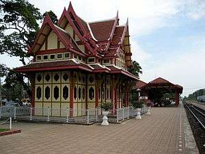
The main station is Hua Hin railway station and it is the northernmost station in the district. Smaller stations are also located in the area including Nong Kae railway station which is closer to Khao Takiap, Suan Son Pradiphat Railway Halt, close to Suan Son Pradiphat Beach and Rajabhakti Park as well as Khao Tao railway station.
There is daily ferry service between Hua Hin and Pattaya[11] and between Hua Hin and Ko Samui, Ko Tao, and Ko Pha-ngan.[12]
Hua Hin Airport is in Hua Hin District. AirAsia serves the airport with a direct flight to Kuala Lumpur.[13]
In August 2018 the Department of Airports announced that it will spend 3.5 billion baht to upgrade Hua Hin Airport over the next five years. The number of travellers using the airport is expected to increase by tenfold, to three million a year, in that timeframe. The upgrade is part of the "Riviera Thailand" and Southern Economic Corridor projects. The work at the airport will take four to five years. It includes enlarging the existing passenger terminal, building a second one, expanding hangar space, and widening the runway from 30 to 45 metres.[14]
Medical
- San Paulo Hospital
- Hua Hin Hospital
- Hua Hin International Polyclinic
- Hua Hin Red Cross
- Bangkok International Hospital
- Dr Pairat Eye Clinic
Education
Hua Hin and Cha-am host a number of tertiary education institutions such as Kasetsart University Veterinary Teaching Hospital,[15] Silpakorn University, Suan Dusit Rajabhat (Hospitality) University, and the Petchaburi Technology and Agricultural University. Webster University Thailand has a campus near Hua Hin,[16] as does the Rajamangala University of Technology Rattanakosin (Wangklaikangwon Campus).
See also
- Ko Sai (Islands off Hua Hin)
- Cha-am District
References
- ↑ "THAILAND: Regions and Major Cities". City Population. Retrieved 15 March 2018.
- ↑ ประกาศสำนักนายกรัฐมนตรี เรื่อง ยกฐานะกิ่งอำเภอหัวหิน อำเภอปราณบุรี จังหวัดประจวบคีรีขันธ์ ขึ้นเป็นอำเภอ (PDF). Royal Gazette (in Thai). 66 (24 ง): 1644. 1949-04-26.
- ↑ Wong, P. P. (1998-04-01). "Coastal tourism development in Southeast Asia: relevance and lessons for coastal zone management". Ocean & Coastal Management. 38 (2): 89–109. doi:10.1016/S0964-5691(97)00066-5.
- ↑ "Thailand bomb blasts target Phuket and Hua Hin tourist spots". BBC. 12 August 2016. Retrieved 13 August 2016.
- ↑ "Tourist hub horror". Bangkok Post. 13 August 2016. Retrieved 13 August 2016.
- ↑ "Thailand bomb blasts: Eight explosions in Hua Hin, Phuket kill four and injure 20". The First Post. AFP. 12 August 2016. Retrieved 13 August 2016.
- ↑ "Climatological Data for the Period 1981–2010". Thai Meteorological Department. p. 22. Retrieved 6 August 2016.
- ↑ "ปริมาณการใช้น้ำของพืชอ้างอิงโดยวิธีของ Penman Monteith (Reference Crop Evapotranspiration by Penman Monteith)" (PDF) (in Thai). Office of Water Management and Hydrology, Royal Irrigation Department. p. 85. Retrieved 6 August 2016.
- ↑ "Population statistics 2015" (in Thai). Department of Provincial Administration. Retrieved 2016-08-12.
- 1 2 Thailand State of Pollution Report 2015 (PDF). Bangkok: Pollution Control Department, Ministry of Natural Resources and Environment (Thailand). 2016. ISBN 978-616-316-327-1. Retrieved 5 September 2017.
- ↑ "Route Time Table". Royal Passenger Liner. Retrieved 1 March 2018.
- ↑ "Home". Lomprayah. Retrieved 1 March 2018.
- ↑ "Regular flights begin at Hua Hin airport". Bangkok Post. 18 May 2018. Retrieved 18 May 2018.
- ↑ "Hua Hin airport due for upgrade, Ratchaburi could get small one". The Nation. 6 August 2018. Retrieved 9 August 2018.
- ↑ "Veterinary Hospital Hua Hin". Faculty of Veterinary Medicine, Kasetsart University. Retrieved 26 January 2018.
- ↑ Webster University Thailand
External links
