Mueang Prachuap Khiri Khan District
| Mueang Prachuap Khiri Khan เมืองประจวบคีรีขันธ์ | |
|---|---|
| District | |
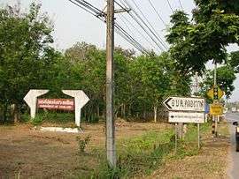
 Beach at tambon Khlong Wan | |
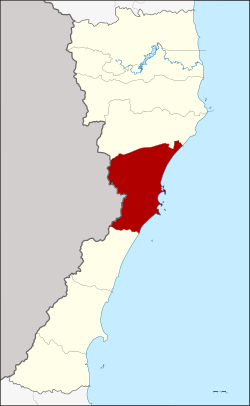 District location in Prachuap Khiri Khan Province | |
| Coordinates: 11°48′30″N 99°47′48″E / 11.80833°N 99.79667°ECoordinates: 11°48′30″N 99°47′48″E / 11.80833°N 99.79667°E | |
| Country | Thailand |
| Province | Prachuap Khiri Khan |
| Area | |
| • Total | 830.0 km2 (320.5 sq mi) |
| Population (2000) | |
| • Total | 90,869 |
| • Density | 109.48/km2 (283.6/sq mi) |
| Time zone | UTC+7 (ICT) |
| Postal code | 77000 |
| Geocode | 7701 |
Mueang Prachuap Khiri Khan (Thai: เมืองประจวบคีรีขันธ์, pronounced [mɯ̄a̯ŋ prā.t͡ɕùa̯p kʰīː.rīː kʰǎn]) is the capital district (amphoe mueang) of Prachuap Khiri Khan Province, central Thailand.
History
During the Ayutthaya period (1351-1767), the district was the site of Na Rang town.[1] In the early-Rattanakosin era, King Rama II established Mueang Bang Nang Rom at the mouth of the Nang Rom canal. But, as the land was not fertile, the king moved the city center to Mueang Kui. The new city name was kept. In the reign of Mongkut, King Rama IV, Bang Nang Rom, Kui, and Klong Wan towns were merged into Prachuap Khiri Khan, meaning 'town with clusters of mountains'.[1] In 1894 King Chulalongkorn placed Mueang Prachuap under Mueang Phetchaburi. In 1899, the town hall was moved from Kui town to Ao Koh Lak, (Ao Prachuap).[1] In 1906 the monarch merged Mueang Pranburi, Kamnoed Nopphakhun, and Prachuap, and established Mueang Pranburi to keep the name of Mueang Pran. The new city was made a province under the control of Monthon Ratchaburi. To prevent city name confusion, King Vajiravudh (Rama VI) changed the district name back to Prachuap Khiri Khan on 16 August 1915.[2]
Geography
The district is known as the "city of three bays", as on its eastern shores are the bays of Ao Noi, Ao Prachuap and Ao Manao.[1]
Neighboring districts are Kui Buri to the north and Thap Sakae to the south. To the west is the Tanintharyi Region of Myanmar, to the east the Gulf of Thailand.
Thailand is at its narrowest in this district, with only 11 km between a point close to the border checkpoint of Dan Sing Khon (ด่านสิงขร) on the Myanmar border and the Gulf of Thailand.[3]
Administration
The district is divided into six sub-districts (tambons), which are further subdivided into 53 villages (mubans). The town (thesaban mueang) of Prachuap Khiri Khan covers the complete tambon Prachuap Khiri Khan as well as parts of Ko Lak and Ao Noi. Parts of tambon Khlong Wan belong to the township Khlong Wan.
| No. | Name | Thai name | Villages | |
|---|---|---|---|---|
| 1. | Prachuap Khiri Khan | ประจวบคีรีขันธ์ | - | |
| 2. | Ko Lak | เกาะหลัก | 11 | |
| 3. | Khlong Wan | คลองวาฬ | 9 | |
| 4. | Huai Sai | ห้วยทราย | 13 | |
| 5. | Ao Noi | อ่าวน้อย | 16 | |
| 6. | Bo Nok | บ่อนอก | 14 |
References
- 1 2 3 4 Svasti, Pichaya (11 October 2018). "A place of gold". Bangkok Post (Life, Travel). Retrieved 11 October 2018.
- ↑ ประกาศ เปลี่ยนนามเมืองปราณบุรี เป็นเมืองประจวบคีรีขันธ์ (PDF). Royal Gazette (in Thai). 32 (0 ก): 176. August 22, 1915.
- ↑ GoogleEarth
| Wikimedia Commons has media related to Mueang Prachuap Khiri Khan District. |