Khao Kho District
| Khao Kho เขาค้อ | |
|---|---|
| Amphoe | |
 Khao Kho in the rain seen from Thailand Route 12 | |
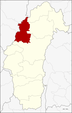 Amphoe location in Phetchabun Province | |
| Coordinates: 16°38′0″N 100°59′54″E / 16.63333°N 100.99833°ECoordinates: 16°38′0″N 100°59′54″E / 16.63333°N 100.99833°E | |
| Country | Thailand |
| Province | Phetchabun |
| Seat | Khao Kho |
| Area | |
| • Total | 1,333.0 km2 (514.7 sq mi) |
| Population (2005) | |
| • Total | 32,932 |
| • Density | 24.7/km2 (64/sq mi) |
| Time zone | UTC+7 (ICT) |
| Postal code | 67270 |
| Geocode | 6711 |
Khao Kho (Thai: เขาค้อ, pronounced [kʰǎw kʰɔ́ː]) is a district (amphoe) of Phetchabun Province, northern Thailand.
Etymology
The name of the district comes from Khao Kho, a peak in the Phetchabun Mountains, named either after Livistona speciosa, a kind of palm tree,[1] or after the Ceylon oak.[2] Both species are known as kho (Thai: ค้อ) in Thai and are abundant in the area.
History
Between 1965-1984, this mountainous area was a battleground in the fight between the Thai communist party and the Royal Thai Army. It was established as a minor district (king amphoe) on 21 August 1984, by splitting the two tambon Thung Samo and Khaem Son from Lom Sak District.[3] It was upgraded to a full district on 19 July 1991.[4]
Geography
Neighboring districts are (from the east clockwise) Lom Kao, Lom Sak and Mueang Phetchabun of Phetchabun Province, Noen Maprang, Wang Thong and Nakhon Thai of Phitsanulok Province, and Dan Sai of Loei Province. The Phetchabun Mountains are a mountain chain in Khao Kho.
Administration
The district is divided into seven sub-districts (tambon), which are further subdivided into 72 villages (muban). There are no municipal areas (thesaban) within the district, and five tambon administrative organizations (TAO).
| No. | Name | Thai name | Villages | Pop. | |
|---|---|---|---|---|---|
| 1. | Khao Kho | เขาค้อ | 14 | 6,467 | |
| 2. | Khaem Son | แคมป์สน | 14 | 5,284 | |
| 3. | Thung Samo | ทุ่งสมอ | 11 | 4,013 | |
| 4. | Rim Si Muang | ริมสีม่วง | 6 | 1,293 | |
| 5. | Sado Phong | สะเดาะพง | 5 | 1,432 | |
| 6. | Nong Mae Na | หนองแม่นา | 10 | 2,594 | |
| 7. | Khek Noi | เข็กน้อย | 12 | 11,849 |
Population
At present, Khek Noi Sub-district is home to the largest Hmong community in Thailand.[5]
References
- ↑ ค้อ: Livistona speciosa Kurz.
- ↑ History of Khao Kho
- ↑ ประกาศกระทรวงมหาดไทย เรื่อง แบ่งเขตท้องที่อำเภอหล่มสัก จังหวัดเพชรบูรณ์ ตั้งเป็นกิ่งอำเภอเขาค้อ (PDF). Royal Gazette (in Thai). 101 (118 ง): 29963. September 4, 1984.
- ↑ พระราชกฤษฎีกาตั้งอำเภอทุ่งตะโก อำเภอพะโต๊ะ อำเภอเขาค้อ อำเภอน้ำหนาว อำเภอวังจันทร์ อำเภอนาด้วง อำเภอเต่างอย อำเภอสิงหนคร อำเภอพระสมุทรเจดีย์ และอำเภอลำดวน พ.ศ. ๒๕๓๔ (PDF). Royal Gazette (in Thai). 108 (107 ก Special): 29–33. June 19, 1991.
- ↑ "คิดเช่น Gen D 08 12 60". Fahwonmai (in Thai). 2017-12-08.