Pattani, Thailand
| Pattani ปัตตานี | ||
|---|---|---|
| Town | ||
| เทศบาลเมืองปัตตานี | ||
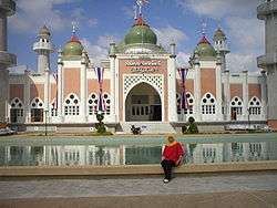 Central Mosque of Pattani | ||
| ||
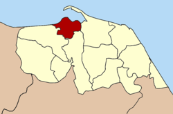 Location in Pattani Province | ||
 Pattani Location in Thailand | ||
| Coordinates: 6°51′59″N 101°15′3″E / 6.86639°N 101.25083°E | ||
| Country | Thailand | |
| Province | Pattani | |
| District | Mueang Pattani | |
| Government | ||
| • Mayor | Pitak Korkiatpitak | |
| Area | ||
| • Total | 4.78 km2 (1.85 sq mi) | |
| Population (2005) | ||
| • Total | 43,631 | |
| • Density | 9,100/km2 (24,000/sq mi) | |
| Time zone | UTC+7 (ICT) | |
| Area code | (+66) 73 | |
| Website |
pattanicity | |

Pattani is a town (thesaban mueang) in the far south of Thailand, near the border with Malaysia. It is the capital of Pattani Province. The city has a population of 43,631 (2005). It covers the whole tambon Sabarang, Anoru and Chabang Tiko of Mueang Pattani district.
Some say the word Pattani is derived from "Petani" in Malay which means "farmer". Alternatively the name Pattani is the Thai adaptation of the Malay name Patani (Jawi: ڤتنا), which can mean "this beach" in Patani Malay language. (In standard Malay, this would be pantai ini.) Another suggestion is that it derives from a Sanskrit word pathini, meaning "virgin nymph"; Pathini was the name of a daughter of Merong Mahawangsa, founder of the preceding Langkasuka Empire. [1]
The local dialect of Malay is called Patani Malay or Yawi in Thai (derived from Jawi).
Pattani lies 1,056 km south of Bangkok.[2]
Climate
| Climate data for Pattani (1981–2010) | |||||||||||||
|---|---|---|---|---|---|---|---|---|---|---|---|---|---|
| Month | Jan | Feb | Mar | Apr | May | Jun | Jul | Aug | Sep | Oct | Nov | Dec | Year |
| Record high °C (°F) | 34.3 (93.7) |
35.9 (96.6) |
37.0 (98.6) |
37.9 (100.2) |
38.0 (100.4) |
36.6 (97.9) |
36.3 (97.3) |
35.8 (96.4) |
36.0 (96.8) |
35.0 (95) |
34.0 (93.2) |
33.9 (93) |
38.0 (100.4) |
| Average high °C (°F) | 30.7 (87.3) |
32.0 (89.6) |
33.2 (91.8) |
34.1 (93.4) |
33.8 (92.8) |
33.3 (91.9) |
33.0 (91.4) |
32.9 (91.2) |
32.4 (90.3) |
31.6 (88.9) |
30.2 (86.4) |
29.6 (85.3) |
32.2 (90) |
| Daily mean °C (°F) | 26.0 (78.8) |
26.5 (79.7) |
27.3 (81.1) |
28.2 (82.8) |
28.2 (82.8) |
27.9 (82.2) |
27.6 (81.7) |
27.5 (81.5) |
27.2 (81) |
26.9 (80.4) |
26.3 (79.3) |
25.9 (78.6) |
27.1 (80.8) |
| Average low °C (°F) | 22.3 (72.1) |
22.1 (71.8) |
22.7 (72.9) |
23.6 (74.5) |
24.2 (75.6) |
24.0 (75.2) |
23.7 (74.7) |
23.7 (74.7) |
23.6 (74.5) |
23.6 (74.5) |
23.5 (74.3) |
23.0 (73.4) |
23.3 (73.9) |
| Record low °C (°F) | 18.6 (65.5) |
16.7 (62.1) |
18.5 (65.3) |
17.4 (63.3) |
21.6 (70.9) |
20.6 (69.1) |
20.4 (68.7) |
21.0 (69.8) |
20.8 (69.4) |
21.3 (70.3) |
21.0 (69.8) |
19.7 (67.5) |
16.7 (62.1) |
| Average rainfall mm (inches) | 50.9 (2.004) |
32.0 (1.26) |
49.4 (1.945) |
74.6 (2.937) |
137.5 (5.413) |
109.4 (4.307) |
129.1 (5.083) |
134.0 (5.276) |
147.1 (5.791) |
216.2 (8.512) |
406.6 (16.008) |
378.3 (14.894) |
1,865.1 (73.429) |
| Average rainy days | 7.5 | 3.1 | 5.7 | 7.3 | 13.2 | 11.0 | 12.8 | 13.2 | 15.5 | 18.3 | 20.4 | 17.3 | 145.3 |
| Average relative humidity (%) | 81 | 79 | 79 | 78 | 80 | 80 | 80 | 80 | 81 | 84 | 86 | 85 | 81 |
| Mean monthly sunshine hours | 145.7 | 166.7 | 148.8 | 144.0 | 114.7 | 111.0 | 114.7 | 114.7 | 108.0 | 111.6 | 105.0 | 108.5 | 1,493.4 |
| Mean daily sunshine hours | 4.7 | 5.9 | 4.8 | 4.8 | 3.7 | 3.7 | 3.7 | 3.7 | 3.6 | 3.6 | 3.5 | 3.5 | 4.1 |
| Source #1: Thai Meteorological Department[3] | |||||||||||||
| Source #2: Office of Water Management and Hydrology, Royal Irrigation Department (sun and humidity)[4] | |||||||||||||
References
- ↑ "{ms} Sejarah Malaysia - Asal Usul nama Sungai Petani". Sejarahmalaysia.pnm.my. Archived from the original on 2013-06-03. Retrieved 2012-08-24.
- ↑ "Distance: Bangkok to Pattani". Google Maps. Retrieved 22 May 2015.
- ↑ "Climatological Data for the Period 1981–2010". Thai Meteorological Department. p. 26. Retrieved 8 August 2016.
- ↑ "ปริมาณการใช้น้ำของพืชอ้างอิงโดยวิธีของ Penman Monteith (Reference Crop Evapotranspiration by Penman Monteith)" (PDF) (in Thai). Office of Water Management and Hydrology, Royal Irrigation Department. p. 126. Retrieved 8 August 2016.
External links

- Official website
Coordinates: 6°51′59″N 101°15′3″E / 6.86639°N 101.25083°E
| ||