Panare District
| Panare ปะนาเระ | |
|---|---|
| Amphoe | |
 Wat Thep Nimit | |
 Amphoe location in Pattani Province | |
| Coordinates: 6°51′36″N 101°29′29″E / 6.86000°N 101.49139°ECoordinates: 6°51′36″N 101°29′29″E / 6.86000°N 101.49139°E | |
| Country | Thailand |
| Province | Pattani |
| Area | |
| • Total | 144.1 km2 (55.6 sq mi) |
| Population (2008) | |
| • Total | 43,131 |
| • Density | 299.0/km2 (774/sq mi) |
| Time zone | UTC+7 (ICT) |
| Postal code | 94130 |
| Geocode | 9404 |
Panare (Thai: ปะนาเระ, pronounced [pā.nāː.réʔ]) is a district (amphoe) in Pattani Province, southern Thailand.
History
The name "Panare" comes from Pattani Malay language. Pata means "sea beach", tare means "otter trawl". Thus Pata Tare means "a beach for drying otter trawls in the air". With time the pronunciation changed to Panare.
Geography
Neighboring districts are (from the south clockwise) Sai Buri, Mayo, and Yaring. To the north and east is the Gulf of Thailand.
Administration
The district is divided into 10 sub-districts (tambon), which are further subdivided into 52 villages (muban). Panare is a sub-district municipality (thesaban tambon) which covers most of tambon Panare. There are further 10 tambon administrative organizations (TAO).
| No. | Name | Thai | Villages | Pop.[1] |
|---|---|---|---|---|
| 1. | Panare | ปะนาเระ | 5 | 9,290 |
| 2. | Tha Kham | ท่าข้าม | 4 | 2,093 |
| 3. | Ban Nok | บ้านนอก | 6 | 4,079 |
| 4. | Don | ดอน | 6 | 3,601 |
| 5. | Khuan | ควน | 5 | 2,437 |
| 6. | Tha Nam | ท่าน้ำ | 5 | 4,249 |
| 7. | Khok Krabue | คอกกระบือ | 4 | 1,866 |
| 8. | Pho Ming | พ่อมิ่ง | 4 | 2,844 |
| 9. | Ban Klang | บ้านกลาง | 9 | 7,146 |
| 10. | Ban Nam Bo | บ้านน้ำบ่อ | 4 | 5,526 |
Gallery
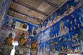 Paintings at Wat Thep Nimit, Ban Klang
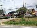 Panare hospital at Tha Kham
.jpg) Ban Klang
Ban Klang.jpg) Countryside at Ban Klang
Countryside at Ban Klang.jpg) Paddy fields and a coconut plantation
Paddy fields and a coconut plantation
References
- ↑ "Population statistics 2008". Department of Provincial Administration.
External links
- amphoe.com (Thai)
This article is issued from
Wikipedia.
The text is licensed under Creative Commons - Attribution - Sharealike.
Additional terms may apply for the media files.