| # | Marker name | County |
Location | Notes |
| 1 | Empire and the Carson River Mills | Carson City |
39°11′14″N 119°42′23″W / 39.187308°N 119.706364°W / 39.187308; -119.706364 |
[2] |
| 2 | Pioneer Memorial Park | Humboldt |
40°58′44″N 117°44′31″W / 40.978823°N 117.741971°W / 40.978823; -117.741971 |
[3] |
| 3 | West End of Hastings Cutoff | Elko |
|
[4] |
| 4 | Junction House—The First Settlement | Washoe |
39°29′20″N 119°47′42″W / 39.488881°N 119.794943°W / 39.488881; -119.794943 |
.jpg) [5]
[5]
|
| 5 | Pioche | Lincoln |
37°55′36″N 114°26′57″W / 37.926679°N 114.449250°W / 37.926679; -114.449250 |
[6] |
| 6 | El Dorado Canyon | Clark |
35°49′39″N 114°56′11″W / 35.827629°N 114.936453°W / 35.827629; -114.936453 |
[7] |
| 7 | Dayton | Lyon |
39°14′11″N 119°35′21″W / 39.236257°N 119.589297°W / 39.236257; -119.589297 |
[8] |
| 8 | Austin | Lander |
39°29′N 117°04′W / 39.49°N 117.07°W / 39.49; -117.07 |
[9] |
| 9 | Copper Country | White Pine |
| [10] |
| 10 | Sand Mountain | Churchill |
| [11] |
| 11 | Eureka | Eureka |
| [12] |
| 12 | Nevada's Birthplace | Douglas |
| [13] |
| 13 | The Comstock Lode | Storey |
| [14] |
| 14 | Goldfield | Esmeralda |
| [15] |
| 15 | Tonopah | Nye |
| [16] |
| 16 | Mineral County | Mineral |
| [17] |
| 17 | Pershing County | Pershing |
| [1] |
| 18 | Pyramid Lake | Washoe |
39°54′10″N 119°33′57″W / 39.902897°N 119.565775°W / 39.902897; -119.565775 |
.jpg) [5]
[5]
|
| 19 | Ragtown | Churchill |
39°30′21″N 118°55′09″W / 39.505722222222°N 118.91928055556°W / 39.505722222222; -118.91928055556 | 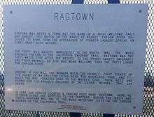 [11] [11] |
| 20 | Columbus | Esmeralda |
| [15] |
| 21 | The Humboldt Canal | Humboldt |
| [3] |
| 22 | Humboldt River | Humboldt |
| [3] |
| 23 | Humboldt House | Pershing |
| [18] |
| 24 | Olinghouse | Washoe |
| [5] |
| 25 | Nevada's Capitol | Carson City |
| [2] |
| 26 | Forty-Mile Desert | Churchill |
| [11] |
| 27 | Grimes Point | Churchill |
| 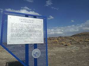 Prehistoric rock art site[11] Prehistoric rock art site[11] |
| 28 | Mark Twain | Storey |
| [14] |
| 29 | Chinese in Nevada | Washoe |
39°32′05″N 119°45′12″W / 39.534713°N 119.753431°W / 39.534713; -119.753431 |

[5] |
| 30 | Reno | Washoe |
39°31′27″N 119°48′45″W / 39.524254°N 119.812417°W / 39.524254; -119.812417 |
 [5]
[5]
|
| 31 | The Old Spanish Trail (1829-1850) | Clark |
| [7] |
| 32 | The Old Spanish Trail (1829-1850) | Clark |
| [7] |
| 33 | The Old Spanish Trail (1829-1850) | Clark |
| [7] |
| 34 | The Old Spanish Trail (1829-1850) | Clark |
| [7] |
| 35 | Las Vegas Mormon Fort and Rancho | Clark |
| Nevada's oldest building[7] |
| 36 | Moapa Valley | Clark |
| [7] |
| 37 | Powell of the Colorado | Clark |
| [7] |
| 38 | Pahranagat Valley | Lincoln |
| [6] |
| 39 | Panaca | Lincoln |
| Southern Nevada's first permanent settlement, from 1864[6] |
| 40 | Las Vegas (The Meadows) | Clark |
| [7] |
| 41 | Pueblo Grande de Nevada | Clark |
| [7] |
| 42 | Big Smoky Valley | Nye |
| [16] |
| 43 | Derby Diversion Dam | Washoe |
| [5] |
| 44 | Carson City | Carson City |
| [2] |
| 45 | Humboldt Wells | Elko |
| [4] |
| 46 | Pilot Peak | Elko |
| [4] |
| 47 | Fort Halleck Military Reservation | Elko |
| 1867-1886[4] |
| 48 | Tuscarora | Elko |
| [4] |
| 49 | Applegate-Lassen Emigrant Trail Cutoff | Pershing |
| [18] |
| 50 | Carlin Canyon | Elko |
| [4] |
| 51 | Schellbourne | White Pine |
39°47′50″N 114°44′28″W / 39.797166666667°N 114.74116666667°W / 39.797166666667; -114.74116666667 |

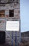
 [10]
[10]
|
| 52 | Cherry Creek | White Pine |
| [10] |
| 53 | Hamilton | White Pine |
| [10] |
| 54 | Ward Mining District | White Pine |
| [10] |
| 55 | Culverwell's Ranch | Lincoln |
| [6] |
| 56 | Virgin Valley | Clark |
| [7] |
| 57 | Old Boundary (Nevada's Southern Boundary 1861-1867) | Lincoln |
| [6] |
| 58 | Old Boundary (Nevada's Southern Boundary 1861-1867) | Nye |
| |
| 59 | Stokes Castle | Lander |
| 
[9] |
| 60 | Hawthorne (Present Mineral County Seat—Former Esmeralda County Seat) | Mineral |
| [19] |
| 61 | Mound House | Lyon |
| [8] |
| 62 | Truckee River – West | Washoe |
39°30′34″N 119°56′13″W / 39.509479°N 119.936821°W / 39.509479; -119.936821 |
.jpg) [5]
[5]
|
| 63 | Truckee River – East | Washoe |
39°33′00″N 119°34′25″W / 39.550130°N 119.573714°W / 39.550130; -119.573714 |
%2C_Nevada_Historical_Marker_No._63%2C_Near_Sparks%2C_Nevada_(18083886531).jpg) [5]
[5]
|
| 64 | Ophir | Nye |
| [16] |
| 65 | Palisade | Eureka |
| [12] |
| 66 | Jacobsville | Lander |
| [9] |
| 67 | Austin Churches | Lander |
| [9] |
| 68 | Wadsworth | Washoe |
| [5] |
| 69 | Jarbidge, Nevada | Elko |
| [4] |
| 70 | Bliss Mansion | Carson City |
| [2] |
| 71 | Methodist Church of Carson City | Carson City |
| [2] |
| 72 | Nevada State Children's Home | Carson City |
| [2] |
| 73 | Unknown Soldiers | Elko |
| [4] |
| 74 | Wellington | Lyon |
| [8] |
| 75 | Government Building | Carson City |
| [2] |
| 76 | Eagle Valley | Carson City |
| [2] |
| 77 | Dat-So-La-Lee | Carson City |
| [2] |
| 78 | Orion Clemens' Home | Carson City |
| [2] |
| 79 | Civil War Plot | Washoe |
39°32′10″N 119°49′12″W / 39.536177°N 119.820027°W / 39.536177; -119.820027 |
.jpg)
[5] |
| 80 | Eureka County Courthouse | Eureka |
| [12] |
| 81 | Grand Army Of The Republic Memorial Tree | Washoe |
39°32′10″N 119°49′01″W / 39.5362352°N 119.8170339°W / 39.5362352; -119.8170339 |
 [5]
[5]
|
| 82 | Diamond Valley | Eureka |
| [12] |
| 83 | Rock Creek (Cold Springs Station) | Churchill |
| [11] |
| 84 | Jedediah Strong Smith (Explorer of the Western Wilderness) | White Pine |
39°17′29″N 114°50′16″W / 39.291497°N 114.837905°W / 39.291497; -114.837905 |
(reported missing since 2013)[20] |
| 85 | Sutro | Lyon |
| [8] |
| 86 | Tule Springs | Clark |
| Archeological Site[7] |
| 87 | Savage Mansion (c. 1863) | Storey |
| [14] |
| 88 | Sparks | Washoe |
39.538231,-119.7670342 |
 [5]
[5]
|
| 89 | Paradise Valley | Humboldt |
| [3] |
| 90 | Delamar | Lincoln |
| "The Widow Maker" (1893-1909)[6] |
| 91 | Stewart Indian School | Carson City |
| [2] |
| 92 | Candelaria and Metallic City | Mineral |
| [19] |
| 93 | Panaca Mercantile Store | Lincoln |
| Built in 1868 as a cooperative for local commerce and trade from Utah[6] |
| 94 | The Winters Ranch (Rancho del Sierra) | Washoe |
| [5] |
| 95 | Battle Mountain | Lander |
| [9] |
| 96 | Round Mountain | Nye |
38°44′34″N 117°07′27″W / 38.74277°N 117.124042°W / 38.74277; -117.124042 |
_(2715227645).jpg) [16]
[16]
|
| 97 | Manhattan "The Pine Tree Camp" | Nye |
| [16] |
| 98 | Osceola (1872-1940) | White Pine |
39°04′17″N 114°26′58″W / 39.071336111111°N 114.44954722222°W / 39.071336111111; -114.44954722222 |
 [10]
[10]
|
| 99 | Taylor | White Pine |
| [10] |
| 100 | Nevada Northern Railway | White Pine |
| [10] |
| 101 | Miller's | Esmeralda |
| [15] |
| 102 | Goodsprings | Clark |
| Mining District (1856-1957)[7] |
| 103 | Gypsum Cave | Clark |
| [7] |
| 104 | The Camel Corps | Clark |
35.172101, -114.710793 | [7] Currently MIA, Removed May 2015 |
| 105 | Golconda | Humboldt |
| [3] |
| 106 | Elko | Elko |
| [4] |
| 107 | Elko Airport | Elko |
| Terminus of the First Commercial Air Mail Route[4] |
| 108 | Ruby Valley Pony Express Station | Elko |
| Reconstructed[4] |
| 109 | Lamoille Valley | Elko |
| [4] |
| 110 | Wagon Jack Shelter | Churchill |
| [11] |
| 111 | Edwards Creek Valley | Churchill |
| [11] |
| 112 | Carlin | Elko |
| [4] |
| 113 | Wabuska | Lyon |
| [8] |
| 114 | Franktown | Washoe |
|
.jpg) [5]
[5]
|
| 115 | Potosi | Clark |
36.000990, -115.485413 | [7] |
| 116 | Searchlight | Clark |
35.468373, -114.922612 | [7] |
| 117 | Kingsbury Grade | Douglas |
38°57′56″N 119°50′23″W / 38.965531°N 119.839669°W / 38.965531; -119.839669 |
 [13]
[13]
|
| 118 | Luther Canyon | Douglas |
| Fay Canyon[13] |
| 119 | Reul Colt Gridley | Lander |
| [9] |
| 120 | Walley's Hot Springs | Douglas |
| [13] |
| 121 | Mottsville | Douglas |
38°55′52″N 119°50′24″W / 38.931094°N 119.840094°W / 38.931094; -119.840094 |
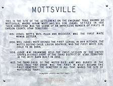 [13] [13]
|
| 122 | Sheridan | Douglas |
| [13] |
| 123 | Cradlebaugh Bridge | Douglas |
| [13] |
| 124 | Boyd Toll Road | Douglas |
| [13] |
| 125 | Twelve Mile House | Douglas |
| [13] |
| 126 | Double Springs, Nevada | Douglas |
| [13] |
| 127 | Courthouse Site (1865-1907) | Lyon |
| [8] |
| 128 | The Great Train Robbery (Nevada) | Washoe |
39.517531,-119.9890372 |
 [5]
[5]
|
| 129 | Gardnerville | Douglas |
| [13] |
| 130 | Minden | Douglas |
| [13] |
| 131 | Dresslerville | Douglas |
| [13] |
| 132 | Mackay Mansion | Storey |
| [14] |
| 133 | Fish Lake Valley | Esmeralda |
| [15] |
| 134 | Trans-Sierran Pioneer Flight | Carson City |
| (March 22, 1919)[2] |
| 135 | New Pass Station | Churchill |
| [11] |
| 136 | Toquima Cave | Lander |
| [9] |
| 137 | Hickison Summit | Lander |
| [9] |
| 138 | Belmont | Nye |
| 
[16] |
| 139 | The Old Spanish Trail (Journey of Death) | Clark |
| [7] |
| 140 | The Old Spanish Trail (Garces Expedition) | Clark |
35.106696, -114.650784 | [7] |
| 141 | The Old Spanish Trail (Armijo's Route) | Clark |
| [7] |
| 142 | The Old Spanish Trail (Mountain Springs Pass) | Clark |
35.998436, -115.447723 | [7] |
| 143 | Sarah Winnemucca Hopkins | Humboldt |
| 1844-1891[3] |
| 144 | Fort McDermitt | Humboldt |
| [3] |
| 145 | Unionville (Pershing County) | Pershing |
| [18] |
| 146 | McDermitt Indian Reservation | Humboldt |
| Northern Paiute[3] |
| 147 | A Home of Early Man | Churchill |
| [11] |
| 148 | The Two Battles Of Pyramid Lake | Washoe |
|
.jpg) [5]
[5]
|
| 149 | High Rock Canyon | Washoe |
| [5] |
| 150 | Nevada's First State Park | Clark |
| [7] |
| 151 | Duck Valley Indian Reservation | Elko |
| [4] |
| 152 | Gerlach | Washoe |
|
.jpg) [5]
[5]
|
| 153 | Jarbidge Community Hall | Elko |
| [4] |
| 154 | Belleville | Mineral |
| [19] |
| 155 | Silver Peak | Esmeralda |
| Discovered 1863[15] |
| 156 | Gold Point | Esmeralda |
| [15] |
| 157 | Lida | Esmeralda |
| [15] |
| 158 | Palmetto | Esmeralda |
| [15] |
| 159 | Ione | Nye |
| [16] |
| 160 | Panaca Spring | Lincoln |
| Warm spring and source of Meadow Valley's fertile lands[6] |
| 161 | Churchill County Courthouse | Churchill |
| [11] |
| 162 | Camp McGarry | Humboldt |
|
 [3]
[3]
|
| 163 | Chinatown | Lyon |
| Early Name of Dayton[8] |
| 164 | Button Point | Humboldt |
| [3] |
| 165 | Nevada Test Site | Nye |
| [16] |
| 166 | Bowers Mansion | Washoe |
|
.jpg) [5]
[5]
|
| 167 | Valmy | Humboldt |
| [3] |
| 168 | Arrowhead Trail (1914-1924) | Clark |
|
%2C_Nevada_Historical_Marker_No._168.jpg) [7]
[7]
|
| 169 | Glendale School | Washoe |
39.534582,-119.7554212 |
 [5]
[5]
|
| 170 | Eureka Sentinel Building | Eureka |
| [12] |
| 171 | Chief Tecopa (Peacemaker of the Paiutes) | Nye |
| [16] |
| 172 | Tybo | Nye |
| [16] |
| 173 | Beatty (Center of the Gold Railroads—"Chicago of the West") | Nye |
|
.jpg) [16]
[16]
|
| 173 | Tate's Stage Station (1886-1901) | Nye |
| [16] |
| 174 | Blair | Esmeralda |
| [15] |
| 175 | Stewart-Nye Residence | Carson City |
| [2] |
| 176 | The Surveyors (Nevada) | Lander |
|
 [9]
[9]
|
| 177 | Desert Well Station (Overland Mail and Stage Station) | Lyon |
| [8] |
| 178 | Hazen | Churchill |
|  [11] [11] |
| 179 | First Air Flights in Nevada | Carson City |
| [2] |
| 180 | The Warm Springs Hotel | Carson City |
| [2] |
| 181 | The Washo Indians | Carson City |
| [2] |
| 182 | Panaca Ward Chapel | Lincoln |
| Oldest building in Lincoln County, built in 1867-68 as a LDS Church meetinghouse[6] |
| 183 | Walker River Reservation | Mineral |
| [19] |
| 184 | Ward Charcoal Ovens | White Pine |
| [10] |
| 185 | McCone's Foundries | Lyon |
| [8] |
| 186 | Union Hotel and Post Office | Lyon |
| [8] |
| 187 | The Cattle Industry | Eureka |
| [12] |
| 188 | Von Schmidt State Boundary Monument | Clark |
35.014259, -114.661825 | [7] |
| 189 | Southern Pacific Railroad Yards | Washoe |
39.534694,-119.7531762 |
 [5]
[5]
|
| 190 | Original Homesite of Pioneer Las Vegas, "Pop" Squires (1865-1958) | Clark |
| [7] |
| 191 | Verdi | Washoe |
| [5] |
| 192 | Buckland's Station (On the California Emigrant Trail) | Lyon |
39.294221, -119.251592 |
 [8]
[8]
|
| 193 | Historic Flume and Lumber Yard | Carson City |
| [2] |
| 194 | Gardner's Ranch | Carson City |
| [2] |
| 195 | The Last Spike | Clark |
| [7] |
| 196 | The United States Mint at Carson City, Nevada | Carson City |
| [2] |
| 197 | Arrowhead Trail II | Clark |
| [7] |
| 198 | Steamboat Springs | Washoe |
|
[5] |
| 199 | Camels in Dayton | Lyon |
| [8] |
| 200 | Hall's Station | Lyon |
| [8] |
| 201 | Wonder Historic Mining Camp | Churchill |
| Historic Mining Camp—1906-1919[11] |
| 202 | Fairview | Churchill |
| 1905-1917[11] |
| 203 | Bullionville | Lincoln |
| [6] |
| 204 | Jackrabbit | Lincoln |
| [6] |
| 205 | Crystal Springs | Lincoln |
| [6] |
| 206 | Hiko | Lincoln |
| [6] |
| 207 | Carson Valley | Douglas |
| [13] |
| 208 | International Hotel | Lander |
| First commercial building constructed in Austin in 1863[9] |
| 209 | Chollar Mine | Storey |
| [14] |
| 210 | Nevada-California-Oregon Railroad Depot | Washoe |
39.531085,-119.8101022 |

 [5]
[5]
|
| 211 | Old Geiger Grade | Washoe |
|
.jpg) [5]
[5]
|
| 212 | Galena | Washoe |
|
.jpg) [5]
[5]
|
| 213 | Lakeview | Carson City |
| [2] |
| 214 | Rafael Rivera | Clark |
| [7] |
| 215 | Lahontan Dam | Churchill |
| [11] |
| 216 | Stillwater | Churchill |
| [11] |
| 217 | Tate's Stage Station | Nye |
| [16] |
| 218 | Geiger Station (Magnolia House) | Washoe |
|
.jpg) [5]
[5]
|
| 219 | Glenbrook | Douglas |
| [13] |
| 220 | The Fight of the Century | Washoe |
39.533192,-119.7970442 |
.jpg) [5]
[5]
|
| 221 | Sand Harbor | Washoe |
39.2005193,-119.9307248 |
 [5]
[5]
|
| 222 | Tannehill Cabin—One of Eureka's First Houses | Eureka |
| [12] |
| 223 | Devil's Gate | Lyon |
| [8] |
| 224 | Kyle Ranch | Clark |
| [7] |
| 225 | Spooner Area | Douglas |
| Logging and Lumber Period: 1868-1895[13] |
| 226 | Cave Rock | Douglas |
| [13] |
| 227 | Lake Mansion | Washoe |
39.522562,-119.8181126 |
 [5]
[5]
|
| 228 | The Great Fire of 1875 | Storey |
| [14] |
| 229 | Oil from Shale | Elko |
| [4] |
| 230 | Mount Rose Weather Observatory | Washoe |
|
.jpg) [5]
[5]
|
| 231 | Star City | Pershing |
|
[18] |
| 232 | Reunion in Unionville | Pershing |
| [18] |
| 233 | Dayton Cemetery | Lyon |
| [8] |
| 234 | Moana Springs | Washoe |
Maps 39°29′32″N 119°48′03″W / 39.4923328°N 119.800851°W / 39.4923328; -119.800851 |
 [5]
[5]
|
| 235 | Camp Nye | Carson City |
| [2] |
| 236 | Piper's Opera House | Storey |
| [14] |
| 237 | Carson and Colorado Railroad Freight Depot | Mineral |
| [19] |
| 238 | Huffaker's | Washoe |
|
.jpg) [5]
[5]
|
| 239 | Stonehouse | Humboldt |
| [3] |
| 240 | Coney Island | Washoe |
Maps 39°32′06″N 119°46′50″W / 39.535005°N 119.780611°W / 39.535005; -119.780611 |
 [5]
[5]
|
| 242 | Southern Nevada Consolidated Telephone-Telegraph Company Building | Esmeralda |
| [15] |
| 243 | Corbett—Fitzsimmons Fight | Carson City |
39°09′52″N 119°45′36″W / 39.164475°N 119.759997°W / 39.164475; -119.759997 |
 [2]
[2]
|
| 244 | Dinner Station | Elko |
| [4] |
| 245 | Frederick Joseph DeLongchamps (June 2, 1882 – February 11, 1969) | Washoe |
39°31′30″N 119°48′44″W / 39.524964°N 119.812281°W / 39.524964; -119.812281 |
.jpg)
[5] |
| 246 | The Great Incline of the Sierra Nevada | Washoe |
39°14′13″N 119°55′44″W / 39.236813°N 119.928778°W / 39.236813; -119.928778 |
.jpg) [5]
[5]
|
| 247 | Site of Nevada's First Public Library | Washoe |
39°31′30″N 119°48′44″W / 39.524964°N 119.812281°W / 39.524964; -119.812281 |
.jpg) [5]
[5]
|
| 248 | Virginia & Truckee Railroad Right of Way | Washoe |
39°30′53″N 119°48′27″W / 39.5146446°N 119.8075372°W / 39.5146446; -119.8075372 |
 [5]
[5]
|
| 249 | Union Pacific Depot—1923 | Lincoln |
| [6] |
| 250 | State Printing Building | Carson City |
| [2] |
| 251 | Diamondfield Jack Davis | Elko |
| [4] |
| 252 | Rinckel Mansion | Carson City |
| [2] |
| 253 | Emigrant—Donner Camp | Washoe |
39°28′34″N 119°45′15″W / 39.476005°N 119.754087°W / 39.476005; -119.754087 |
.jpg) [5]
[5]
|
| 254 | Nevada's Mining Heritage | Eureka |
| [12] |
| 255 | Wilson Canyon | Lyon |
| [8] |
| 256 | Historic Transportation | Washoe |
| [5] |
| 257 | Nevada's First Gold Discovery | Lyon |
| [8] |
| 258 | Charles W. Friend House, Observatory, and Weather Station | Carson City |
| [2] |
| 259 | The Governor's Mansion | Carson City |
| [2] |
| 260 | Contact | Elko |
| [4] |
| 261 | Spooner Summit | Douglas |
| [13] |
| 262 | Dayton School House - 1865 | Lyon |
| [8] |
| 263 | Oats Park School | Churchill |
| [11] |
| 265 | Governor Emmet Derby Boyle | Washoe |
| [5] |
| 266 | African Americans and the Boston Saloon | Storey |
| [14] |