Elgin, Nevada
| Elgin | |
|---|---|
| Ghost town | |
 Elgin Location within the state of Nevada  Elgin Elgin (the US) | |
| Coordinates: 37°21′07″N 114°32′09″W / 37.35194°N 114.53583°WCoordinates: 37°21′07″N 114°32′09″W / 37.35194°N 114.53583°W | |
| Country | United States |
| State | Nevada |
| County | Lincoln[1] |
| Elevation | 3,410 ft (1,040 m) |
| Population (2000) | |
| • Total | 14 |
| Time zone | UTC-8 (Pacific (PST)) |
| • Summer (DST) | UTC-7 (PDT) |
Elgin /ˈɛldʒɪn/ is a ghost town located between Caliente and Carp, Nevada on the eastern banks of the Meadow Valley Wash off of Nevada State Route 317.
The first settlement at Elgin was made in 1882.[2] A post office was established at Elgin in 1913, and remained in operation until 1966.[3]
A former railroad town, it is now the location of the Elgin Schoolhouse State Historic Site, a one-room schoolhouse museum. There is an apple orchard nearby.
As of May 2008, the State Historic Site is permanently closed due to the damage to the only road leading to the site, Nevada State Route 317, caused by flooding.
References
- ↑ U.S. Geological Survey Geographic Names Information System: Elgin
- ↑ Federal Writers' Project (1941). Origin of Place Names: Nevada (PDF). W.P.A. p. 44.
- ↑ U.S. Geological Survey Geographic Names Information System: Elgin Post Office (historical)
External links
Municipalities and communities of Lincoln County, Nevada, United States | ||
|---|---|---|
| Cities | 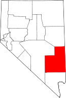 | |
| CDPs | ||
| Other unincorporated communities | ||
| Ghost towns | ||
| Footnotes | ‡This populated place also has portions in an adjacent county or counties | |
This article is issued from
Wikipedia.
The text is licensed under Creative Commons - Attribution - Sharealike.
Additional terms may apply for the media files.