Nye County, Nevada
| Nye County, Nevada | ||
|---|---|---|
| County | ||
| Nye County | ||
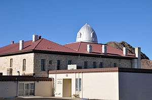 Nye County Courthouse in Tonopah | ||
| ||
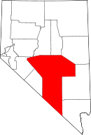 Location in the U.S. state of Nevada | ||
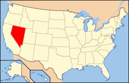 Nevada's location in the U.S. | ||
| Founded | 1864 | |
| Named for | James W. Nye | |
| Seat | Tonopah | |
| Largest community | Pahrump | |
| Area | ||
| • Total | 18,199 sq mi (47,135 km2) | |
| • Land | 18,182 sq mi (47,091 km2) | |
| • Water | 17 sq mi (44 km2), 0.1% | |
| Population | ||
| • (2010) | 43,946 | |
| • Density | 2.4/sq mi (0.9/km2) | |
| Congressional district | 4th | |
| Time zone | Pacific: UTC−8/−7 | |
| Website |
nyecounty | |


Nye County is a county located in the U.S. state of Nevada. As of the 2010 census, the population was 43,946.[1] Its county seat is Tonopah.[2] At 18,159 square miles (47,030 km2), Nye is the largest county by area in the state and the third-largest county in the contiguous United States (thus excluding the boroughs of Alaska).
Nye County comprises the Pahrump, NV Micropolitan Statistical Area, which is included in the Las Vegas-Henderson, NV-AZ Combined Statistical Area.
In 2010, the center of population of Nevada was located in southern Nye County, very near Yucca Mountain.[3]
The Nevada Test Site and proposed Yucca Mountain nuclear waste repository are located in the southwestern part of the county, and are the focus of a great deal of political and public controversy in the state. The federal government manages 92 percent of the land in the county. A 1987 attempt to deposit the nuclear waste resulted in the creation of Bullfrog County, Nevada, which was dissolved two years later.
The county features several environmentally sensitive areas, including Ash Meadows National Wildlife Refuge, the White River Valley, several Great Basin sky islands and a portion of Death Valley National Park. Visitors to Death Valley often stay at Beatty or Amargosa Valley.
Nye County is one of 11 Nevada counties where prostitution is legal. The county has no incorporated cities. The seat of government in Tonopah is 160 miles (260 km) from Pahrump, where about 86 percent of the county's population resides. Nye County is nicknamed "The Kingdom of Nye" from the radio program Coast to Coast AM, created by the late Pahrump resident Art Bell.
History
Nye County was established during the American Civil War in 1864 and named after James W. Nye. He served as the first governor of the Nevada Territory and later as a U.S. Senator after it was admitted as a state. The first county seat was Ione in 1864, followed by Belmont in 1867, and finally by Tonopah in 1905.
The county's first boom came in the early 20th century, when Rhyolite and Tonopah, as well as Goldfield in nearby Esmeralda County, all had gold and silver mining booms. In 1906, Goldfield had 30,000 residents, Tonopah had nearly 10,000 people, and Rhyolite peaked at about 10,000. These cities were linked by the Tonopah and Tidewater Railroad.[4]
After the boom died, Nye County withered. By 1910, the population had plummeted to about 7,500 before sinking to near 3,000 in the middle of the century.[5] It was not until development at the military test site, increasing employment and resources that the population stabilized. After the 1990s, when Pahrump became a bedroom community for Las Vegas, it had high rates of population growth.
From time to time, there have been discussions of moving the county seat south to Pahrump, or splitting off the southern portion of the county, but neither of these ideas appears to have sufficient support at the county or state government level.[6]
From 1987 to 1989, Bullfrog County, Nevada, was split off from Nye County territory to form a separate political region. The population of Bullfrog County was 0; the county's creation was strictly a political maneuver to support plans for a nuclear waste storage facility in the region. The Western Shoshone challenged this plan, saying they had never ceded land in this territory. No license was granted for the planned Yucca Mountain Repository. The Yomba Indian Reservation is located in this county, as one designated for some of the Western Shoshone people. The Yomba Band of the reservation is a federally recognized tribe.
Geography
According to the U.S. Census Bureau, the county has a total area of 18,199 square miles (47,140 km2), of which 18,182 square miles (47,090 km2) is land and 17 square miles (44 km2) (0.09%) is water.[7] The highest and most topographically prominent mountain in the county is Mount Jefferson at 11,949 feet (3,642 m).[8]
Nye County is located in south central Nevada. Nye is the largest county in Nevada and is the third-largest county in the contiguous United States, after San Bernardino County in California and Coconino County in Arizona. With a land area of 11,560,960 acres (46,785.5 km2), Nye County is larger than the combined total area of Massachusetts, Rhode Island, New Jersey, and Delaware. Of this vast land area, only 822,711 acres (3,329.39 km2), or just over seven percent of the total, is private land; the majority of the county's land are public lands managed by the federal government. Before the Treaty of Ruby Valley, all this area was controlled by the Western Shoshone people, who say they never ceded territory here. According to the United States Census Bureau the county's Census Tract 9805, with a land area of 4,225.415 square miles (10,943.77 km2), comprising the Nevada Test Site and Nye County's portion of the Nevada Test and Training Range, is the largest census tract in the United States that has absolutely no resident population (as of the 2000 census).
Las Vegas, in Clark County, is 100 miles (160 km) southeast of Yucca Mountain. Many Pahrump residents commute 60 miles (97 km) each way to Las Vegas via Nevada State Route 160, which for much of its length is a four-lane divided highway.
Major highways
Nye County has a long stretch of U.S. Route 95, the main road connecting the state's population center in Las Vegas with the state capital in Carson City. Beatty and Tonopah both rely heavily on through traffic to sustain their economies. As of 2006, an average of 2,000 cars daily traveled U.S. 95 near Tonopah.[9]
Adjacent counties
- Churchill County - northwest
- Lander County - north
- Eureka County - north
- White Pine County - northeast
- Lincoln County - east
- Clark County - east
- Esmeralda County - west
- Mineral County - west
- Inyo County, California - south
National protected areas
Demographics
| Historical population | |||
|---|---|---|---|
| Census | Pop. | %± | |
| 1870 | 1,087 | — | |
| 1880 | 1,875 | 72.5% | |
| 1890 | 1,290 | −31.2% | |
| 1900 | 1,140 | −11.6% | |
| 1910 | 7,513 | 559.0% | |
| 1920 | 6,504 | −13.4% | |
| 1930 | 3,989 | −38.7% | |
| 1940 | 3,606 | −9.6% | |
| 1950 | 3,101 | −14.0% | |
| 1960 | 4,374 | 41.1% | |
| 1970 | 5,599 | 28.0% | |
| 1980 | 9,048 | 61.6% | |
| 1990 | 17,781 | 96.5% | |
| 2000 | 32,485 | 82.7% | |
| 2010 | 43,946 | 35.3% | |
| Est. 2016 | 43,423 | [10] | −1.2% |
| U.S. Decennial Census[11] 1790-1960[12] 1900-1990[13] 1990-2000[14] 2010-2013[1] | |||
2000 census
As of the census[15] of 2000, there were 32,485 people, 13,309 households, and 9,063 families residing in the county. The population density was 2 people per square mile (1/km²). There were 15,934 housing units at an average density of 1 per square mile (0/km²). The racial makeup of the county was 90.0% White, 1.18% Black or African American, 1.96% Native American, 0.78% Asian, 0.32% Pacific Islander, 2.98% from other races, and 3.15% from two or more races. 8.35% of the population were Hispanic or Latino of any race.
In 2006 there were 42,693 people living in Nye County, representing a growth of 31.3% since 2000. This was slightly faster growth rate than recorded during the same period for Clark County, where Las Vegas is located.
Even as the Pahrump area grew thanks to its proximity to Las Vegas, the racial makeup of Nye County was very different from that of Clark County. Non-Hispanic whites now constitute 82.7% of the county population. African-Americans were now 1.7% of the population, which meant actual increase of the number of African Americans residing in the county was over 50%. Native Americans were only 1.8% of the population now. Asians were a full one percent of the population. Pacific Islanders were 0.5% of the population and Latinos made up 11.0% of the population.[16]
In 2000 there were 13,309 households out of which 16.40% had children under the age of 18 living with them, 26.30% were married couples living together, 7.40% had a female householder with no husband present, and 31.90% were non-families. 25.70% of all households were made up of individuals and 10.30% had someone living alone who was 65 years of age or older. The average household size was 2.42 and the average family size was 2.90.
In the county, the population was spread out with 3.70% under the age of 18, 5.40% from 18 to 24, 24.00% from 25 to 44, 58.50% from 45 to 64, and 18.40% who were 65 years of age or older. The median age was 43 years. For every 100 females there were 105.10 males. For every 100 females age 18 and over, there were 104.70 males.
The median income for a household in the county was $36,024, and the median income for a family was $41,642. Males had a median income of $37,276 versus $22,394 for females. The per capita income for the county was $17,962. About 7.30% of families and 10.70% of the population were below the poverty line, including 13.10% of those under age 18 and 8.30% of those age 65 or over.
Like many rural counties of the western United States, Nye County experiences a relatively high suicide rate.[17] According to the Centers for Disease Control, the annual suicide rate in Nye County averaged 28.7561 per 100,000 people during 1989–1998, the most recent period for which data is available. This was the third-highest rate amongst Nevada counties, behind White Pine (34.3058) and Lyon County (30.8917), but ahead of the overall rate of 22.96 for Nevada, which leads the nation.
2010 census
As of the 2010 United States Census, there were 43,946 people, 18,032 households, and 11,929 families residing in the county.[18] The population density was 2.4 inhabitants per square mile (0.93/km2). There were 22,350 housing units at an average density of 1.2 per square mile (0.46/km2).[19] The racial makeup of the county was 85.9% white, 2.0% black or African American, 1.6% American Indian, 1.3% Asian, 0.5% Pacific islander, 5.2% from other races, and 3.5% from two or more races. Those of Hispanic or Latino origin made up 13.6% of the population.[18] In terms of ancestry, 18.6% were German, 15.8% were English, 14.7% were Irish, 10.3% were American, and 6.1% were Italian.[20]
Of the 18,032 households, 25.1% had children under the age of 18 living with them, 51.5% were married couples living together, 9.3% had a female householder with no husband present, 33.8% were non-families, and 26.8% of all households were made up of individuals. The average household size was 2.42 and the average family size was 2.90. The median age was 48.4 years.[18]
The median income for a household in the county was $41,181 and the median income for a family was $50,218. Males had a median income of $51,574 versus $32,152 for females. The per capita income for the county was $22,687. About 14.2% of families and 18.9% of the population were below the poverty line, including 27.8% of those under age 18 and 9.8% of those age 65 or over.[21]
Education
The Nye County School District serves all of Nye County and Esmeralda County. The Districts Headquarters is located in the county seat of Tonopah. The current superintendent of the NCSD is Dale Norton.
Communities
Inhabited communities
Census-designated places
- Beatty CDP
- Gabbs CDP
- Pahrump CDP
- Tonopah CDP
Ghost towns
In popular culture
Nye County was the one of the primary broadcast locations of American veteran radio broadcaster Art Bell, who was famous for creating and hosting Coast to Coast AM, Art Bell's Dark Matter and most recently, "Midnight in the Desert." This program still contues to be broadcast by a replacement host, Dave Schrader, chosen by Bell himself and airing on the Dark Matter Digital Network. He resided in the county until his death on April 13, 2018.[23][24]
Nye County was a featured location in two episodes of Studio 60 on the Sunset Strip.
Many episodes from the 1950s Television show State Trooper take place in both Tonopah and Goldfield.
Nye County is featured weekly on the A&E television program Live PD.
Politics
| Year | Republican | Democratic | Third parties |
|---|---|---|---|
| 2016 | 68.0% 13,324 | 26.0% 5,094 | 6.0% 1,177 |
| 2012 | 60.3% 10,566 | 36.1% 6,320 | 3.6% 636 |
| 2008 | 54.5% 9,537 | 41.3% 7,226 | 4.2% 728 |
| 2004 | 58.5% 8,487 | 38.7% 5,616 | 2.8% 407 |
| 2000 | 56.7% 6,904 | 37.2% 4,525 | 6.2% 752 |
| 1996 | 43.2% 3,979 | 35.8% 3,300 | 21.0% 1,932 |
| 1992 | 34.2% 2,743 | 31.9% 2,561 | 33.9% 2,718 |
| 1988 | 64.6% 3,619 | 31.2% 1,748 | 4.2% 236 |
| 1984 | 71.6% 3,573 | 25.4% 1,269 | 3.0% 147 |
| 1980 | 64.2% 2,387 | 26.2% 973 | 9.7% 360 |
| 1976 | 42.5% 1,027 | 52.2% 1,261 | 5.3% 127 |
| 1972 | 61.6% 1,287 | 38.4% 802 | |
| 1968 | 40.7% 843 | 35.2% 728 | 24.1% 500 |
| 1964 | 39.2% 822 | 60.8% 1,276 | |
| 1960 | 43.5% 763 | 56.6% 993 | |
| 1956 | 55.8% 946 | 44.2% 749 | |
| 1952 | 64.7% 1,037 | 35.4% 567 | |
| 1948 | 51.9% 722 | 42.8% 595 | 5.3% 73 |
| 1944 | 43.4% 723 | 56.6% 943 | |
| 1940 | 37.7% 729 | 62.3% 1,206 | |
| 1936 | 23.7% 464 | 76.3% 1,495 | |
| 1932 | 28.1% 506 | 71.9% 1,296 | |
| 1928 | 46.0% 958 | 54.0% 1,123 | |
| 1924 | 39.7% 884 | 20.4% 454 | 39.9% 889 |
| 1920 | 54.4% 1,576 | 34.7% 1,007 | 10.9% 316 |
| 1916 | 32.2% 1,019 | 50.5% 1,601 | 17.4% 550 |
| 1912 | 14.6% 345 | 36.8% 869 | 48.5% 1,145[26] |
| 1908 | 40.5% 1,124 | 44.0% 1,219 | 15.5% 430 |
| 1904 | 50.7% 511 | 38.6% 389 | 10.6% 107 |
See also
References
- 1 2 "State & County QuickFacts". United States Census Bureau. Retrieved September 23, 2013.
- ↑ "County Explorer". National Association of Counties. Retrieved June 7, 2011.
- ↑ "Download the Centers of Population by State: 2010". United States Census Bureau. Archived from the original on January 3, 2014. Retrieved December 20, 2014.
- ↑ "Ghost Towns and History of the American West". Ghosttowns.com. Retrieved 2016-01-01.
- ↑ "Nye County, NV Population by Decades". Archived from the original on July 13, 2009.
- ↑ Mark Waite (January 9, 2001). "View Newspapers: Resident proposes new county formation". The Vie. Archived from the original on July 17, 2011.
- ↑ "2010 Census Gazetteer Files". United States Census Bureau. August 22, 2012. Retrieved December 20, 2014.
- ↑ "Mount Jefferson, Nevada". Peakbagger.com. Retrieved January 19, 2013.
- ↑ Nevada Department of Transportation AADT report Archived January 21, 2008, at the Wayback Machine.
- ↑ "Population and Housing Unit Estimates". Retrieved June 9, 2017.
- ↑ "U.S. Decennial Census". United States Census Bureau. Archived from the original on May 12, 2015. Retrieved December 20, 2014.
- ↑ "Historical Census Browser". University of Virginia Library. Retrieved December 20, 2014.
- ↑ "Population of Counties by Decennial Census: 1900 to 1990". United States Census Bureau. Retrieved December 20, 2014.
- ↑ "Census 2000 PHC-T-4. Ranking Tables for Counties: 1990 and 2000" (PDF). United States Census Bureau. Retrieved December 20, 2014.
- ↑ "American FactFinder". United States Census Bureau. Archived from the original on September 11, 2013. Retrieved January 31, 2008.
- ↑ "Nye County QuickFacts from the US Census Bureau". Quickfacts.census.gov. Retrieved 2016-01-01.
- ↑ Las Vegas Review-Journal: Rural Suicide: Soaring rates puzzling
- 1 2 3 "DP-1 Profile of General Population and Housing Characteristics: 2010 Demographic Profile Data". United States Census Bureau. Retrieved 2016-01-21.
- ↑ "Population, Housing Units, Area, and Density: 2010 - County". United States Census Bureau. Retrieved 2016-01-21.
- ↑ "DP02 SELECTED SOCIAL CHARACTERISTICS IN THE UNITED STATES – 2006-2010 American Community Survey 5-Year Estimates". United States Census Bureau. Retrieved 2016-01-21.
- ↑ "DP03 SELECTED ECONOMIC CHARACTERISTICS – 2006-2010 American Community Survey 5-Year Estimates". United States Census Bureau. Retrieved 2016-01-21.
- ↑ "Carrara - Nevada Ghost Town". Ghosttowns.com. Retrieved 2016-01-01.
- ↑ "Live from Pahrump: Art Bell, master of the paranormal, makes radio return Monday". Las Vegas Sun. 2013-09-13. Retrieved 2017-05-09.
- ↑ "R.I.P. Art Bell, king of late-night conspiracy radio". The A.V. Club. 2018-04-14.
- ↑ Leip, David. "Dave Leip's Atlas of U.S. Presidential Elections". uselectionatlas.org. Retrieved 2018-04-12.
- ↑ Progressive candidate Theodore Roosevelt, received 427 votes, while Socialist candidate Eugene Debs received 718 votes.
External links
- Official website
- Nye County Nuclear Waste Repository Project Office
- Nye County and Census Tract 9805, Nye County, Nevada United States Census Bureau
Places adjacent to Nye County, Nevada | ||||||||||
|---|---|---|---|---|---|---|---|---|---|---|
| ||||||||||
Municipalities and communities of Nye County, Nevada, United States | ||
|---|---|---|
| Unincorporated towns | | |
| Other unincorporated communities | ||
| Ghost towns | ||