Duckwater, Nevada
| Duckwater | |
|---|---|
| Unincorporated community | |
 | |
 Duckwater Location of Duckwater in Nevada | |
| Coordinates: 38°55′55″N 115°42′54″W / 38.93194°N 115.71500°WCoordinates: 38°55′55″N 115°42′54″W / 38.93194°N 115.71500°W | |
| Country | United States |
| State | Nevada |
| County | Nye |
| Area | |
| • Total | 4,346.4 sq mi (11,257 km2) |
| Elevation | 5,480 ft (1,670 m) |
| Population (2010) | |
| • Total | 228 |
| • Density | 0.052/sq mi (0.020/km2) |
| Time zone | UTC-8 (Pacific) |
| • Summer (DST) | UTC-7 (PDT) |
| ZIP code | 89314 |
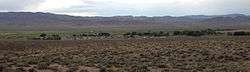
Duckwater is an American village located in the central portion of the U.S. state of Nevada, in the Duckwater Valley at about the same latitude as Sacramento, California. It is in Nye County, at the eastern edge of the Duckwater Indian Reservation, near the Red Mountain Wilderness at the end of Nevada State Route 379. The city of Las Vegas is about 200 miles to the south-southeast.
A post office was established at Duckwater in 1873.[1] The community was named for the ducks which frequented wetlands near the original town site.[2]
All children may attend the Nye County School District's Duckwater School but Native American children may electively attend the Duckwater Shoshone Elementary School (D.S.E.S.), located on the reservation. D.S.E.S. is tribally-controlled and operated, with the majority of funding derived from the Bureau of Indian Affairs, Office of Indian Education. Both schools are K-8 one-room schools. Most students in grades 8-12 attend Eureka County High School, 47 miles north of Duckwater.
References
- ↑ U.S. Geological Survey Geographic Names Information System: Duckwater Post Office
- ↑ Federal Writers' Project (1941). Origin of Place Names: Nevada (PDF). W.P.A. p. 55.
Municipalities and communities of Nye County, Nevada, United States | ||
|---|---|---|
| Unincorporated towns | 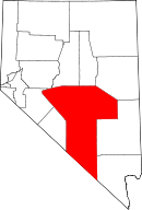 | |
| Other unincorporated communities | ||
| Ghost towns | ||
| Wikimedia Commons has media related to Duckwater, Nevada. |