Northwest China
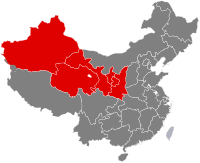
Northwestern China (Chinese: 西北; pinyin: Xīběi) includes the autonomous regions of Xinjiang and Ningxia and the provinces of Shaanxi, Gansu, and Qinghai.
| Northwest China | |
|---|---|
| Population [1] | 96.6 million |
Administrative divisions
| GB[2] | ISO №[3] | Province | Chinese Name | Capital | Population | Density | Area | Abbreviation/Symbol |
|---|---|---|---|---|---|---|---|---|
| SN | 61 | Shaanxi Province | 陕西省 Shǎnxī Shěng |
Xi'an | 37,327,378 | 181.55 | 205,600 | 陕(秦) Shǎn (Qín) |
| GS | 62 | Gansu Province | 甘肃省 Gānsù Shěng |
Lanzhou | 25,575,254 | 56.29 | 454,300 | 甘(陇) Gān (Lǒng) |
| QH | 63 | Qinghai Province | 青海省 Qīnghǎi Shěng |
Xining | 5,626,722 | 7.80 | 721,200 | 青 Qīng |
| NX | 64 | Ningxia Hui Autonomous Region | 宁夏回族自治区 Níngxià Huízú Zìzhìqū |
Yinchuan | 6,301,350 | 94.89 | 66,400 | 宁 Níng |
| XJ | 65 | Xinjiang Uyghur Autonomous Region | 新疆维吾尔自治区 Xīnjiāng Wéiwú'ěr Zìzhìqū |
Ürümqi | 21,813,334 | 13.13 | 1,660,400 | 新 Xīn |
Cities with urban area over one million in population
| # | City | Urban area[4] | District area[4] | City proper[4] | Prov. | Census date |
|---|---|---|---|---|---|---|
| 1 | Xi'an | 5,206,253 | 6,501,190 | 8,467,838 | SN | 2010-11-01 |
| 2 | Ürümqi | 2,853,398 | 3,029,372 | 3,112,559 | XJ | 2010-11-01 |
| 3 | Lanzhou | 2,438,595 | 2,628,426 | 3,616,163 | GS | 2010-11-01 |
| 4 | Yinchuan | 1,159,457 | 1,290,170 | 1,993,088 | NX | 2010-11-01 |
| 5 | Xining | 1,153,417 | 1,198,304 | 2,208,708 | QH | 2010-11-01 |
Outer Northwest China
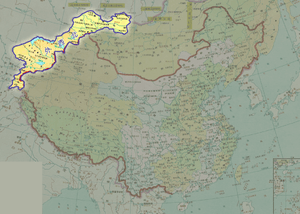
Outer Northwest China (Chinese: 外西北; pinyin: Wài Xīběi) is the territories that were ceded from Qing dynasty of China to Russian Empire in Convention of Peking, Treaty of Tarbagatai, Treaty of Saint Petersburg (1881) and other Unequal Treaties. The territories are former parts of far western Xinjiang and northwestern Outer Mongolia and all of Tannu Uriankhai. Historically, Outer Northwest China was part of Dzungaria but was obtained by the Manchus after their defeat of the Dzungars in the 18th century.
Following the dissolution of the Soviet Union, the territories were separated and are now governed by four successors of USSR: Kazakhstan, Kyrgyzstan, Tajikistan and Russia.
See also
References
- ↑ "List of regions of the People's Republic of China - Wikipedia". en.m.wikipedia.org. Retrieved 31 March 2018.
- ↑ CHGIS. "Database Design". www.people.fas.harvard.edu. Retrieved 31 March 2018.
- ↑ ISO 3166-2:CN (ISO 3166-2 codes for the provinces of China)
- 1 2 3 国务院人口普查办公室、国家统计局人口和社会科技统计司编 (2012). 中国2010年人口普查分县资料. Beijing: 中国统计出版社 [China Statistics Press]. ISBN 978-7-5037-6659-6.