Mengcun Hui Autonomous County
| Mengcun County 孟村县 · مْعڞٌ | |
|---|---|
| Autonomous county | |
|
孟村回族自治县 · مْعڞٌ خُوِذُو ذِجِشِیًا Mengcun Hui Autonomous County | |
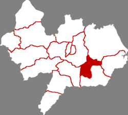 Mengcun in Cangzhou | |
.png) Cangzhou in Hebei | |
| Coordinates: 38°03′11″N 117°06′14″E / 38.053°N 117.104°ECoordinates: 38°03′11″N 117°06′14″E / 38.053°N 117.104°E | |
| Country | People's Republic of China |
| Province | Hebei |
| Prefecture-level city | Cangzhou |
| County seat | Mengcun Town (孟村镇) |
| Area | |
| • Total | 384 km2 (148 sq mi) |
| Elevation | 13 m (43 ft) |
| Population (2010) | |
| • Total | 193,000 |
| • Density | 500/km2 (1,300/sq mi) |
| Time zone | UTC+8 (China Standard) |
| Postal code | 061400 |
| Area code(s) | 0317 |
Mengcun (Chinese: 孟村回族自治县; pinyin: Mèngcūn huízú zìzhìxiàn; Xiao'erjing: مْعڞٌ خُوِذُو ذِجِشِیًا) is a Hui autonomous county of southeastern Hebei province, China, under the administration of Cangzhou City. As of 2010, it has a population of 193,000 residing in an area of 384 km2 (148 sq mi).
Administrative divisions
There are 4 towns and 2 townships under the county's administration.[1]
Towns:
Townships:
- Songzhuangzi Township (宋庄子乡), Niujinzhuang Township (牛进庄乡)
References
- ↑ 2011年统计用区划代码和城乡划分代码:孟村回族自治县 (in Chinese). National Bureau of Statistics of the People's Republic of China. Retrieved 2012-07-18.
This article is issued from
Wikipedia.
The text is licensed under Creative Commons - Attribution - Sharealike.
Additional terms may apply for the media files.