Weishan Yi and Hui Autonomous County
| Weishan County 巍山县 · وِشًا | |
|---|---|
| Autonomous county | |
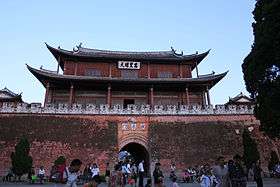 Gongchen Tower, atop the Gongchen Gate, is a symbol of Weishan | |
.png) Location of Weishan County (pink) in Dali Prefecture (yellow) and Yunnan | |
| Coordinates: 25°13′37″N 100°18′25″E / 25.227°N 100.307°ECoordinates: 25°13′37″N 100°18′25″E / 25.227°N 100.307°E | |
| Country | People's Republic of China |
| Province | Yunnan |
| Autonomous prefecture | Dali |
| Area | |
| • Total | 2,200 km2 (800 sq mi) |
| Population (2010) | |
| • Total | 304,400 |
| • Density | 140/km2 (360/sq mi) |
| Time zone | UTC+8 (CST) |
| Postal code | 672400 |
| Area code(s) | 0872 |
| Climate | Cwb |
| Website |
www |
Weishan Yi and Hui Autonomous County (Chinese: 巍山彝族回族自治县; pinyin: Wēishān Yízú Huízú Zìzhìxiàn; Xiao'erjing: وِشًا یِذُو خُوِذُو ذِجِشِیًا) is an autonomous county in the Dali Bai Autonomous Prefecture, in the west-central part of Yunnan Province, China. It was known as Menghua (蒙化) until the 1950s.
Geography
It is situated in the upper section of the Ailao Mountains and the Wuliang Mountains.
Climate
| Climate data for Weishan (1981−2010) | |||||||||||||
|---|---|---|---|---|---|---|---|---|---|---|---|---|---|
| Month | Jan | Feb | Mar | Apr | May | Jun | Jul | Aug | Sep | Oct | Nov | Dec | Year |
| Record high °C (°F) | 23.6 (74.5) |
25.6 (78.1) |
29.6 (85.3) |
31.5 (88.7) |
34.3 (93.7) |
32.5 (90.5) |
31.9 (89.4) |
31.2 (88.2) |
31.0 (87.8) |
28.8 (83.8) |
25.4 (77.7) |
22.6 (72.7) |
34.3 (93.7) |
| Average high °C (°F) | 17.4 (63.3) |
18.9 (66) |
22.2 (72) |
25.0 (77) |
26.6 (79.9) |
26.5 (79.7) |
25.8 (78.4) |
26.2 (79.2) |
25.2 (77.4) |
23.4 (74.1) |
20.2 (68.4) |
17.7 (63.9) |
22.9 (73.3) |
| Daily mean °C (°F) | 8.5 (47.3) |
10.3 (50.5) |
13.5 (56.3) |
16.9 (62.4) |
20.1 (68.2) |
21.7 (71.1) |
21.2 (70.2) |
20.8 (69.4) |
19.4 (66.9) |
17.0 (62.6) |
12.4 (54.3) |
8.9 (48) |
15.9 (60.6) |
| Average low °C (°F) | 1.5 (34.7) |
3.1 (37.6) |
6.1 (43) |
10.1 (50.2) |
14.7 (58.5) |
18.2 (64.8) |
18.3 (64.9) |
17.5 (63.5) |
16.0 (60.8) |
13.1 (55.6) |
7.2 (45) |
2.8 (37) |
10.7 (51.3) |
| Record low °C (°F) | −4.0 (24.8) |
−2.4 (27.7) |
−0.9 (30.4) |
2.5 (36.5) |
7.7 (45.9) |
12.3 (54.1) |
12.9 (55.2) |
11.6 (52.9) |
6.8 (44.2) |
5.0 (41) |
0.6 (33.1) |
−4.5 (23.9) |
−4.5 (23.9) |
| Average precipitation mm (inches) | 17.8 (0.701) |
21.7 (0.854) |
24.9 (0.98) |
27.6 (1.087) |
64.5 (2.539) |
119.2 (4.693) |
157.3 (6.193) |
145.9 (5.744) |
109.6 (4.315) |
86.2 (3.394) |
31.1 (1.224) |
9.8 (0.386) |
815.6 (32.11) |
| Average relative humidity (%) | 67 | 62 | 59 | 59 | 63 | 73 | 80 | 83 | 82 | 79 | 76 | 73 | 71 |
| Source: China Meteorological Data Service Center | |||||||||||||
External links
This article is issued from
Wikipedia.
The text is licensed under Creative Commons - Attribution - Sharealike.
Additional terms may apply for the media files.