Navotas
| Navotas | ||
|---|---|---|
| Highly Urbanized City | ||
| City of Navotas | ||
.JPG) Aerial view of Navotas | ||
| ||
| Nickname(s): Commercial Fishing Hub of the Philippines | ||
| Motto(s): Itaas ang antas ng Buhay-Navoteño (Raise the Level of the Navoteño Life.) | ||
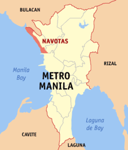 Map of Metro Manila with Navotas highlighted | ||
.svg.png) Navotas Location within the Philippines | ||
| Coordinates: 14°40′00″N 120°56′30″E / 14.6667°N 120.9417°ECoordinates: 14°40′00″N 120°56′30″E / 14.6667°N 120.9417°E | ||
| Country |
| |
| Region | National Capital Region (NCR) | |
| Province | none (Former part of Rizal province until 1975) | |
| District | Lone district | |
| Chartered | December 20, 1827 | |
| Cityhood and HUC | June 24, 2007 | |
| Barangays | 18 (see Barangays) | |
| Government [1] | ||
| • Type | Sangguniang Panlungsod | |
| • Mayor | John Rey Tiangco | |
| • Vice Mayor | Clint Geronimo | |
| • Congressman | Tobias Reynald M. Tiangco | |
| • Councilors |
List
| |
| • Electorate | 125,795 voters (2016) | |
| Area [2] | ||
| • Total | 10.77 km2 (4.16 sq mi) | |
| Population (2015 census)[3] | ||
| • Total | 249,463 | |
| • Density | 23,000/km2 (60,000/sq mi) | |
| Demonym(s) | Navoteño | |
| Time zone | UTC+8 (PST) | |
| ZIP code | 1409, 1411–1413, 1485, 1489–1490 | |
| PSGC | 137503000 | |
| IDD : area code | +63 (0)2 | |
| Climate type | Tropical monsoon climate | |
| Income class | 1st city income class | |
| Revenue (₱) | 941,848,230.31 (2016) | |
| Native languages |
Tagalog Taglish Swardspeak | |
| Website |
www | |

Navotas, officially the City of Navotas, (Tagalog: Lungsod ng Navotas), or simply known as Navotas City, is a 1st class highly urbanized city in Metro Manila, Philippines. According to the 2015 census, it has a population of 249,463 people.[3]
It is known as the Commercial Fishing Hub of the Philippines where the city has the third largest fish port in Asia and the largest in Southeast Asia. Although it was established on December 20, 1827, Navotas celebrates its foundation day every January 16. Navotas became a highly-urbanized city on June 24, 2007.[4]
Etymology
The entire region of Navotas was once part of Malabon. According to one legend, the long and narrow delta extended unbroken from north to south along the seashore. The strip of land between the former district of Tondo, Manila and this town was eaten away by the sea until an opening was made. Water began to flow through the opening. The geographical change prompted the people to refer to the place as "butas", "nayon ng butas", or "nabutas", a Tagalog word that means breached or pierced through. What began as a natural channel developed into a regular waterway, now known as the Navotas River. In later years, the place came to be known as "Nabotas", then "Navotas".
It was also known as Hacienda de Navotas; it was once owned by the Dominican friars until it was sold to the Pascual family during the early days of the American regime and developed into a residential estate.
San Jose de Navotas was the name given to the locality after its patron saint, Saint Joseph. On June 11, 1859, a "Superior Decreto" established a new parish and municipality under the supervision of Friar Matias Navoa. The populace was divided into two distinct groups, the naturales (locals) and the mestizos. Mariano Estrellas was the gobernadorcillo (petty governor) of the naturales and Mariano Israel, of the mestizos. Today, because records are incomplete, recognition is only given to the gobernadorcillos for the mestizos. A school in honor of San Jose was built and known as "San Jose Academy."
History
Historical timeline
- December 20, 1827 – The movement for separation of Navotas which was then a part of Malabon (Tambobong).
- February 16, 1859 – The date when the barrios of San Jose, Navotas and Bangculasi were separated from Malabon.
- 1859 – Cavada, the year when Navotas became an independent town.
- August 6, 1898 – Navotas joined the revolutionary government of General Emilio Aguinaldo.
- June 11, 1901 – Navotas was eventually incorporated into the newly created province of Rizal enacted Act. No. 137.
- 1904 - the town was again merged with Malabon. Bernardo Dagala, a native of Navotas, was elected municipal president.
- January 16, 1906 – Navotas finally became an independent municipality with the enactment of Act. No. 1442 which separated it from Malabon.
- January 16, 2006 - Navotas celebrated its centennial
- June 24, 2007 – Navotas became a highly urbanized city after a plebiscite was conducted.
Origin and Historical Development
Years ago, the town of Navotas was not known by its present name for it was only considered as part of Malabon. The place appeared to be a long and narrow delta with a thick line of pandan leaves, which grew abundantly extending from north to south along the seashore. It was believed that long ago, the town was not entirely surrounded by water. Old folks believed that the layer of land between the former district of Tondo, Manila and this town was probably soft and weak, such that the turbulent waters of the bay gradually eroded a portion of the land, until an opening was made. Soon seawater begun to flow through its opening especially during high tide. At low tide, the waters from inland flowed out into the sea. This geographical change prompted the people to refer to the place as “nabutas” which means breached or pierced through. This developed into a regular waterway, now known as the Navotas River. In later years, the whole place came to be known as Navotas. 4 The movement for a separate Navotas, which was by that time part of Tambobong, now Malabon started on December 20, 1827 when the “principales” of the three barrios of San Jose, Navotas, and Bangkulasi petitioned the Spanish Government to form a new town citing among others, the difficulty of the people to transact business and attend religious festivities of the mother town. On October 31, 1832, the residents of the three barrios nominated Don Bernabe Francisco to represent them in their fight for separation from Malabon. But the petition of the principales of the three barrios was shelved by the government on September 19, 1855 pending the putting up by the people of Navotas of a church, convent, and a town hall that symbolized their sincerity. In spite of the determined efforts of the principales, their petition was again disapproved on August 19, 1856. Instead of being discouraged, the successive rebuff only served to prod them to work harder. Finally, a document dated February 16, 1859 recorded the separation of barrios San Jose, Navotas, and Bangkulasi from Malabon. When the Philippine Revolution broke out in 1896, Navotas formally joined the revolutionary government of Gen. Emilio Aguinaldo on August 6, 1898. On June 11, 1901, the town of Navotas was incorporated into the newly created province of Rizal by virtue of Philippine Commission Act No. 137. In 1903, by virtue of the Philippine Commission Act No. 942, the municipalities of Malabon and Navotas were merged into one by which the former was chosen as the seat of government for economic and centralization purposes. Bernardo Dagala of Navotas fought for the separation of Navotas from Malabon, finally, Navotas gained full independence as a distinct municipality through the enforcement of the Philippine Commission Act No. 142 lasts January 16, 1906. On November 1975, in the exercise of emergency power during martial law of then President Ferdinand E. Marcos, Presidential Decree No. 824 created the Metropolitan Manila Commission, which placed Navotas together with twelve (12), other municipalities of Rizal and the four (4) cities under its jurisdiction. Today, Navotas, after a long wait, was proclaimed as a full-pledge city last June 24, 2007, upon obtaining 12,544 affirmative votes on a plebiscite. Navotas, together with the other fifteen (15) cities and one (1) municipality (Pateros) remain part of Metropolitan Manila, particularly of the National Capital Region (NCR). As mandated by the Local Government Code of 1991, this LGU is also guided by various devolved, deconcentrated and concerned National Government Agencies likewise encouraging the support and participation of the Non-Government Organization on its undertaking towards national development.5
Geography
Topography
Navotas is a coastal town in the northwest part of Metro Manila. It is a narrow strip of land with an aggregated shoreline of approximately 4.5 km. In the north, Navotas shares a common border with the town of Obando, Bulacan, along Sukol Creek which separates it from Balt. Along the eastern border runs the Binuangan River, the Daang Cawayan River, the Dampalit River, the Batasan River, the Navotas River, the Bangculasi Channel, the Malabon Channel and the Estero de Maypajo.
It is bordered on the north by Obando, Bulacan along Sukol Creek; on the south by the city of Manila; on the east by Daang Binuangan River, Bangkulasi Channel, Malabon Channel and Estero de Maypajo; and on the west by Manila Bay.
City Government
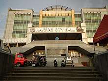
Political Profile
With regards to the separation of Navotas from Malabon in 1859 and the organization thereof as a distinct municipality or “pueblo” with its own government and church, this town was headed by the governadorcillos who exercised executive and judicial functions. However, as this locality was composed of two groups the naturales and the mestizos, each of which had its own governadorcillo appointed by the governor-general who was the supreme authority in all local matters, since the inhabitants did not allow choosing their officials. This political system was somehow revoked at the end of the Spanish Regime through the Maura Law of 1883, which guided some of the selected officials to the supervision of an insular authority. During the revolutionary period (from 1898-1902), as the democratic system of local governance was being established via the First Philippines Republic and Malolos Constitution, people of Navotas with high character, social position and honorable conduct gathered in a meeting and elected the chief of the town, the headman of the barrio (barangay) and three officials viz., for police and internal order, justice and civil registry, and taxes and property. In this situation, these elected officials constitute an assembly wherein the chief of the town was the president, the headman, the vice-president, and the justice officer the secretary. In this period, the name of Navotas LGU and its head were changed from “pueblo to municipality” and from “President to Mayor”. Philippine Commission, which exercised supervision over local government, appointed the first local official. Gradually, election of officials was allowed.
During the period of the Philippine Commonwealth (from 1935-1945), the 1935 constitution ushered. This provided that the President of the Philippines should exercise general supervision over all local governments. This allowed Navotas to have three (3) leaders. This trend from 1946 to 1972 (during the second Philippine Republic) was toward decentralization. Congress passed laws giving more autonomy to Local Government Units through the grant of additional powers and lessening of national control affairs. This created four (4) Mayors of Navotas. During the Martial Law Period, President Marcos had changed the structure and functions of LGU’s, thus decentralization suffered the set back with the concentration of power on his hands. After December 31, 1975 (expiration of tenure of office of the local elective officials), the President assumed the power of appointment of the officials as authorized by the people in a referendum held on 27 February 1975. During the Marcos Regime, Navotas had two (2) Mayors.
Navotas was proclaimed as a full-fledged city by virtue of RA 9387[5] that converted the municipality of Navotas into a highly urbanized city. A plebiscite was held on June 24, 2007 which was ratified the conversion of Navotas into a highly urbanized city.
Barangays
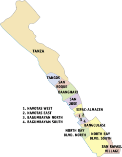
Navotas is politically subdivided into 2 districts, with a total of 18 barangays:
| Barangays | District | Population[6] (2010) |
Area (km²) | Density (/km²) | Zip Code |
|---|---|---|---|---|---|
| Bagumbayan North | 1st | 2,652 | |||
| Bagumbayan South | 1st | 4,524 | |||
| Bangkulasi | 1st | 8,263 | |||
| Navotas East | 1st | 2,241 | |||
| Navotas West | 1st | 8,698 | |||
| NBBS Dagat-dagatan (Northbay Boulevard South) | 1st | ||||
| NBBS Kaunlaran (Northbay Boulevard South) | 1st | 68,375 | |||
| NBBS Proper (Northbay Boulevard South) | 1st | ||||
| Northbay Boulevard North | 1st | 16,201 | |||
| San Rafael Village | 1st | 3,530 | |||
| Sipac-Almacen | 1st | 11,541 | |||
| Daanghari | 2nd | 19,179 | |||
| San Jose | 2nd | 28,153 | 1485 | ||
| San Roque | 2nd | 17,916 | |||
| Tangos North (Tangos) | 2nd | ||||
| Tangos South (Tangos) | 2nd | 32,941 | 1489 | ||
| Tanza 1 (Tanza) | 2nd | 24,917 | 1490 | ||
| Tanza 2 (Tanza) | 2nd |
Barangay North Bay Boulevard South was split into Barangay NBBS Kaunlaran, Barangay NBBS Dagat-dagatan, and Barangay NBBS Proper, pursuant to Republic Act No. 10933, which was ratified through a plebiscite conducted by the COMELEC on 05 January 2018.
Barangay Tangos was divided into Barangay Tangos North and Barangay Tangos South, pursuant to Republic Act No. 10934, which was ratified through a plebiscite conducted by the COMELEC on 05 January 2018.
Barangay Tanza was divided into Barangay Tanza 1 and Barangay Tanza 2, pursuant to Republic Act No. 10935, which was ratified through a plebiscite conducted by the COMELEC on 05 January 2018.
Demographics
| Population census of Navotas | ||
|---|---|---|
| Year | Pop. | ±% p.a. |
| 1903 | 11,688 | — |
| 1918 | 13,454 | +0.94% |
| 1939 | 20,861 | +2.11% |
| 1948 | 28,889 | +3.68% |
| 1960 | 49,262 | +4.55% |
| 1970 | 83,245 | +5.38% |
| 1975 | 97,098 | +3.14% |
| 1980 | 126,146 | +5.37% |
| 1990 | 187,479 | +4.04% |
| 1995 | 229,039 | +3.82% |
| 2000 | 230,403 | +0.13% |
| 2007 | 245,344 | +0.87% |
| 2010 | 249,131 | +0.56% |
| 2015 | 249,463 | +0.03% |
| Source: Philippine Statistics Authority[3][7][8][9] | ||
Education
Navotas has 15 public elementary schools and 6 public secondary schools including Navotas National High School.[10] The Navotas Polytechnic College located at the North Bay Boulevard South in Kaunlaran Village is owned and operated by the city.
Transportation
Transportation in Navotas are composed of different vehicles.
Notable people/groups
- General Dionisio Santiago (ret), former Chief-of-Staff of the Armed Forces of the Philippines
- Froilan Baguion, professional basketball player
- Engracia Cruz-Reyes, chef and entrepreneur
- Jorella Marie de Jesus, professional volleyball player
- Navotas All-Star/Finest, Various Hip-hop group/s & artist/s (Tanza to San Rafael)
- Gerald Santos, singer and actor
- Wendy Valdez, beauty queen, and an actress.
- Jannie Loudette Vicencio Alipo-on, Miss Tourism International 2017.
Twin towns / Sister cities
References
- ↑
- ↑ "Province: NCR, THIRD DISTRICT (Not a Province)". PSGC Interactive. Quezon City, Philippines: Philippine Statistics Authority. Retrieved 12 November 2016.
- 1 2 3 Census of Population (2015). "National Capital Region (NCR)". Total Population by Province, City, Municipality and Barangay. PSA. Retrieved 20 June 2016.
- ↑ Navotas becomes Metro Manila's newest city. Retrieve June 24, 2007
- ↑ "Republic Act No. 9387: An Act Conventing the Municipality of Navotas into a Highly Urbanized City to be Known as the City of Navotas". The Corpus Juris. The Corpus Juris. Retrieved 9 March 2016.
- ↑
- ↑ Census of Population and Housing (2010). "National Capital Region (NCR)". Total Population by Province, City, Municipality and Barangay. NSO. Retrieved 29 June 2016.
- ↑ Censuses of Population (1903–2007). "National Capital Region (NCR)". Table 1. Population Enumerated in Various Censuses by Province/Highly Urbanized City: 1903 to 2007. NSO.
- ↑ "Province of Metro Manila, 3rd (Not a Province)". Municipality Population Data. Local Water Utilities Administration Research Division. Retrieved 17 December 2016.
- ↑ "Schools List" (PDF). Navotas City Website. Retrieved January 23, 2015.
External links
| Wikivoyage has a travel guide for Navotas. |
| Wikimedia Commons has media related to Navotas. |
