Mercer Island, Washington
| Mercer Island, Washington | |
|---|---|
| City | |
 Aerial view of Mercer Island from the north. | |
| Nickname(s): MI | |
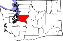
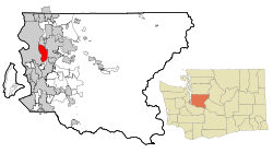 Location of Mercer Island in King County, Washington | |
| Coordinates: 47°34′39″N 122°12′43.2″W / 47.57750°N 122.212000°WCoordinates: 47°34′39″N 122°12′43.2″W / 47.57750°N 122.212000°W | |
| Country | United States |
| State | Washington |
| County | King |
| Area[1] | |
| • Total | 13.11 sq mi (33.95 km2) |
| • Land | 6.32 sq mi (16.37 km2) |
| • Water | 6.79 sq mi (17.59 km2) |
| Elevation[2] | 338 ft (103 m) |
| Population (2010)[3] | |
| • Total | 22,699 |
| • Estimate (2017) | 25,261 |
| • Density | 3,591.6/sq mi (1,386.7/km2) |
| Time zone | UTC-8 (Pacific (PST)) |
| • Summer (DST) | UTC-7 (PDT) |
| ZIP code | 98040 |
| Area code(s) | 206 |
| FIPS code | 53-45005 |
| GNIS feature ID | 1512455[4] |
| Website | www.mercergov.org |
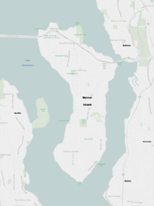
Mercer Island is a city in King County, Washington, United States located on an island of the same name in the southern portion of Lake Washington. Mercer Island is in the Seattle Metropolitan Area,[5] with Seattle located to its west and Bellevue located to its east.
Mercer Island is connected to the mainland on both sides by bridges carrying Interstate 90. The Lacey V. Murrow Memorial Bridge and the parallel Homer M. Hadley Memorial Bridge are floating bridges that span Lake Washington and carry, respectively, eastbound and westbound lanes of Interstate 90 and connect Mercer Island to the northern portion of Seattle's South End (more specifically, I-90 has Leschi to the north and Mount Baker to the south). I-90 traverses the northern portion of Mercer Island and is then carried from the island to Bellevue over the East Channel of Lake Washington by the East Channel Bridge. Mercer Island is located closer to Bellevue than it is to Seattle, and is therefore often considered to be part of the King County's Eastside.
The population was 25,261 in a 2017 census estimate. Mercer Island is the most populated island in a lake within the United States.[6] The ZIP code 98040 is unique to Mercer Island.[7] Mercer Island has the fifth highest per-capita income in the state of Washington and is one of the 100 richest ZIP codes in the USA according to the IRS figures for Adjusted Gross Income.[8]
History
Mercer Island, named for the Mercer family of Seattle, was first settled between 1870 and 1880. The Mercer brothers often rowed between the island and Seattle to pick berries, hunt, and fish. Those brothers, Thomas Mercer and Asa Mercer, were members of the Mercer family of Virginia. The first large settlement, East Seattle, was toward the northwest side of the island—near the McGilvra neighborhood. During 1889, a C C Calkins built a large and gilded resort, the Calkins Hotel. The hotel was reached via steamboat between Madison Park, Leschi Park, and the Eastside. Guests included President Benjamin Harrison, of 1901, amongst other well-to-do dignitaries from Seattle to the Eastcoast of the USA. Burnt by a mysterious fire, the hotel was razed during 1908.
The Calkins Landing continued service and presumedly aided location of a more permanent population. A denser urban community with business district developed toward the central northern island between the McGilvra neighborhood and Luther Burbank Park. This community now composes the majority of the island's crest through the Middle Island neighborhood.
In 1928, the East Channel Bridge was built to connect the island with Bellevue, Washington. In 1930, George W Lightfoot requested a bridge between Mercer Island and Seattle. The Lacey V Murrow Memorial Bridge, currently the second longest floating bridge on Earth, was built and opened in 1940. In 1989, a second bridge, the Homer M Hadley Memorial Bridge, was built parallel to the Lacey V Murrow Memorial Bridge. The East Channel Bridge, Lacey V Murrow Memorial Bridge, and Homer M Hadley Memorial Bridge, carry Interstate 90 from Seattle, through Mercer Island, and into Bellevue. (Another floating bridge, the Governor Albert D. Rosellini Bridge—Evergreen Point, was built across Lake Washington in 1963, north of Mercer Island. It connects Seattle and Medina.)
The City of Mercer Island was incorporated from East Seattle on July 5, 1960 and composed of all the island less the 70 acre (280,000 m²) business district. Just over one month later, August 9, the Town of Mercer Island was incorporated from that business district. The two aforementioned municipalities merged as the City of Mercer Island May 19, 1970.
Geography

Mercer Island City Hall is located at 47°34′39″N 122°12′43.2″W / 47.57750°N 122.212000°W (47.5775, -122.212).[9] The peak elevation is about 338 feet near the center of the island.[2]
According to the United States Census Bureau, the city has a total area of 13.11 square miles (33.95 km2), of which, 6.32 square miles (16.37 km2) is land and 6.79 square miles (17.59 km2) is water.[1]
Mercer Island is the largest populated island in a lake in the US.[10]
Climate
This region experiences warm (but not hot) and dry summers, with no average monthly temperatures above 71.6 °F. According to the Köppen Climate Classification system, Mercer Island has a warm-summer Mediterranean climate, abbreviated "Csb" on climate maps.[11]
Education
The Mercer Island School District comprises seven common schools on the island: four primary schools (Lakeridge Elementary, Island Park Elementary, West Mercer Elementary and Northwood Elementary); one Middle school (Islander Middle School); one High school (Mercer Island High School); one alternative secondary school (Crest Learning Center).[12]
Mercer Island is also home to the St. Monica School(K-8), the French American School of Puget Sound (P-8), and the Northwest Yeshiva High School (9-12).
Demographics
| Historical population | |||
|---|---|---|---|
| Census | Pop. | %± | |
| 1970 | 19,047 | — | |
| 1980 | 21,522 | 13.0% | |
| 1990 | 20,816 | −3.3% | |
| 2000 | 22,036 | 5.9% | |
| 2010 | 22,699 | 3.0% | |
| Est. 2017 | 25,261 | 11.3% | |
| U.S. Decennial Census[13] 2017 Estimate[14] | |||
According to a 2012 estimate, the median income for a household in the city was $127,360, and the median income for a family was $154,050. The per capita income for the city was $74,056.
Washington State's Office of Financial Management also publishes per-county, per-city population statistics of its own. Its 2013 estimate was 22,720.[15]
An estimated 25% of city households are Jewish; the Island also has two synagogues and a Jewish Community Center.[16]
2010 census
As of the census[3] of 2010, there were 22,699 people, 9,109 households, and 6,532 families residing in the city. The population density was 3,591.6 inhabitants per square mile (1,386.7/km2). There were 9,930 housing units at an average density of 1,571.2 per square mile (606.6/km2). The racial makeup of the city was 77.9% White, 1.3% African American, 0.2% Native American, 15.9% Asian, 0.1% Pacific Islander, 0.7% from other races, and 3.9% from two or more races. Hispanic or Latino of any race were 2.8% of the population.
There were 9,109 households of which 33.5% had children under the age of 18 living with them, 62.3% were married couples living together, 6.5% had a female householder with no husband present, 2.9% had a male householder with no wife present, and 28.3% were non-families. 24.1% of all households were made up of individuals and 11.8% had someone living alone who was 65 years of age or older. The average household size was 2.48 and the average family size was 2.97.
The median age in the city was 46 years. 24.6% of residents were under the age of 18; 4.8% were between the ages of 18 and 24; 19% were from 25 to 44; 32% were from 45 to 64; and 19.5% were 65 years of age or older. The gender makeup of the city was 48.7% male and 51.3% female.
2000 census
As of the census of 2000, there were 22,036 people, 8,437 households, and 6,277 families residing in the city. The population density was 3,452.0 inhabitants per square mile (1,333.6/km²). There were 8,806 housing units at an average density of 1,379.5 per square mile (532.9/km²). The racial makeup of the city was 84.09% White, 1.14% African American, 0.16% Native American, 11.87% Asian, 0.07% Pacific Islander, 0.52% from other races, and 2.16% from two or more races. Hispanic or Latino of any race were 1.86% of the population.
There were 8,437 households out of which 35.5% had children under the age of 18 living with them, 65.6% were married couples living together, 6.7% had a female householder with no husband present, and 25.6% were non-families. 22.1% of all households were made up of individuals and 11.2% had someone living alone who was 65 years of age or older. The average household size was 2.58 and the average family size was 3.03.
In the city the population was spread out with 26.0% under the age of 18, 4.2% from 18 to 24, 21.2% from 25 to 44, 29.9% from 45 to 64, and 18.7% who were 65 years of age or older. The median age was 44 years. For every 100 females, there were 92.7 males. For every 100 females age 18 and over, there were 88.3 males.
The median income for a household in the city was $91,904, and the median income for a family was $110,830. Males had a median income of $82,855 versus $46,734 for females. The per capita income for the city was $53,799. About 1.9% of families and 3.2% of the population were below the poverty line, including 3.4% of those under age 18 and 2.3% of those age 65 or over.
Government
At the national level, Mercer Island is located in Washington's 9th congressional district, which is currently represented by Democrat Adam Smith.
Parks
Luther Burbank Park covers 77 acres (310,000 m2) of land and has 0.75 miles (1.21 km) of waterfront. The park has a public boat dock and fishing pier, a swimming beach, an amphitheater, tennis courts, barbecues and picnic facilities, and an off-leash dog area.[17] The city assumed maintenance of the park on January 1, 2003 from King County, which had purchased the park land in 1969.[18]
The Aubrey Davis Park is atop the I-90 tunnel entrances. This park has softball fields, tennis courts, basketball courts, picnic shelters, and the Freeway Sculpture Park. Due to its location atop the I-90 tunnel, the park is also locally referred to as "The Lid." [19] [20]
Pioneer Park covers 113 acres (0.46 km2) and has equestrian, bicycle, and hiking trails.[21] Deane's Children's Park, also known as "Dragon Park", is a small park with playground equipment.[22]
Clarke Beach is located at the south end of Mercer Island and is home to the annual polar bear swim on New Year's Day.
Mercer Island also has many smaller parks maintained by the city, some of which have waterfront access.
Sister cities
Mercer Island's sister city, as designated by Sister Cities International, is Thonon-les-Bains, France.[23][24]
Annual events
- Mercer Island is focal to annual performances by the Blue Angels during Seattle's summer Seafair celebration.
- Summer Celebration is a celebration once a year on the weekend after the 4th of July. The celebration ends with fireworks.[25]
- The Mercer Island Farmers Market operates most Sundays between June and October. A special version of the market called the Harvest Market occurs on a Sunday in November. There is no farmer's market on the Summer Celebration weekend nor on the Seafair weekend. The market contains local produce including fruit, vegetables and some crafts. [26]
Gallery
| Wikimedia Commons has media related to Mercer Island, Washington. |
 Luther Burbank Park
 Keewaydin Clubhouse
 Luther Burbank Park docks
 Luther Burbank School
Notable people
- Paul Allen, co-founder of Microsoft[27]
- Ann Dunham, mother of President Barack Obama[28]
- Rashard Lewis, former NBA player[29]
- George Lightfoot, promoter for building the Lacey V. Murrow Memorial Bridge
- Howard Lincoln, former chairman of Nintendo of America, current CEO and chairman of the Seattle Mariners[30]
- Joel McHale, comedian[31]
- Steve Miller of the Steve Miller Band[32]
- Jordan Morris, Forward for the Seattle Sounders FC[33]
- Bill Russell, Boston Celtics NBA player, 1956–1969, and Hall of Famer[30]
- Frank Shrontz, former CEO and chairman of Boeing[30]
- Quin Snyder, head coach of the Utah Jazz
- Mary Wayte, two-time Olympic gold medal swimmer[34]
References
- 1 2 "US Gazetteer files 2010". United States Census Bureau. Archived from the original on January 24, 2012. Retrieved December 19, 2012.
- 1 2 "Mercer Island Topographic Map". Sameer Burle. Retrieved July 21, 2015.
- 1 2 "American FactFinder". United States Census Bureau. Retrieved December 19, 2012.
- ↑ "Mercer Island". Geographic Names Information System. United States Geological Survey.
- ↑ Update of Statistical Area Definitions and Guidance on Their Uses Archived 2008-11-17 at the Wayback Machine., Office of Management and Budget, November 20, 2007. Accessed 2008-12-10.
- ↑ "Demographics".
- ↑ "AreaConnect Zip Code Finder".
- ↑ http://wealth.mongabay.com/tables/100_income_zip_codes-10000.html
- ↑ "US Gazetteer files: 2010, 2000, and 1990". United States Census Bureau. February 12, 2011. Retrieved April 23, 2011.
- ↑ "American Island Superlatives".
- ↑ "Mercer Island, Washington Köppen Climate Classification (Weatherbase)".
- ↑ "Groundbreaking ceremony scheduled at future site of new elementary school - Mercer Island Reporter". Mercer Island Reporter. Retrieved 2015-11-21.
- ↑ United States Census Bureau. "Census of Population and Housing". Retrieved July 31, 2013.
- ↑ "City and Town Population Totals: 2010-2017". United States Census Bureau. Retrieved June 1, 201. Check date values in:
|accessdate=(help) - ↑ "April 1, 2013 Population of Cities, Towns and Counties Used for Allocation of Selected State Revenues State of Washington" (PDF). April 1, 2013. Retrieved July 31, 2013.
- ↑ "Seattle's Jewish population jumped by 70 percent, study finds". 2015-02-02.
- ↑ "Luther Burbank Park". City of Mercer Island. Retrieved 2017-04-09.
- ↑ "History". City of Mercer Island. Retrieved 2017-04-09.
- ↑ "Aubrey Davis Park". City of Mercer Island. Retrieved 2017-04-09.
- ↑ Morris, Keiko (February 23, 1998). "A Sculpture Garden Grows On Island `Lid'". Seattle Times. Retrieved March 11, 2009.
- ↑ "Pioneer Park". City of Mercer Island. Retrieved 2017-04-09.
- ↑ "Deane's Children's Park". City of Mercer Island. Retrieved 2017-04-09.
- ↑ "Sister Cities International". Retrieved August 1, 2012.
- ↑ "Mercer Island Sister City Association - Welcome".
- ↑ "City of Mercer Island - Summer Celebration! Homepage". Retrieved August 2, 2012.
- ↑ "Mercer Island Farmer's Market Homepage". Retrieved June 9, 2017.
- ↑ Bracetti, Alex. "The Most Baller Mansions of Tech CEOs". Complex.com. Complex Media Inc. Retrieved December 26, 2014.
- ↑ http://www.seattletimes.com/seattle-news/politics/obamas-mother-known-here-as-uncommon/
- ↑ http://www.seattlepi.com/news/article/Meet-the-Sonics-Rashard-Lewis-1098265.php
- 1 2 3 Glascock, Stuart (August 6, 2008). "No longer an isle unto themselves". Los Angeles Times. Retrieved December 26, 2014.
- ↑ Metzger, Katie. "No longer an isle unto themselves". Retrieved 17 Dec 2017.
- ↑ Cohen, Aubrey (9/6/2014). "Steve Miller's former home flies like an eagle off the market". seattlePI. seattlePI. Retrieved 29 May 2018. Check date values in:
|date=(help) - ↑ Livarchik, Joe (January 22, 2016). "It's official: Mercer Island's Morris signs with Sounders". Mercer Island Reporter. Retrieved July 6, 2016.
- ↑ http://community.seattletimes.nwsource.com/archive/?date=20031014&slug=flashback14
External links
- City of Mercer Island official website
- Mercer Island Reporter Local newspaper
Municipalities and communities of King County, Washington, United States | ||
|---|---|---|
| Cities |
|  |
| Towns | ||
| CDPs |
| |
| Unincorporated communities | ||
| Indian reservation | ||
| Ghost towns | ||
| Footnotes | ‡This populated place also has portions in an adjacent county or counties | |
