Enumclaw, Washington
| City of Enumclaw, Washington | |
|---|---|
| City | |
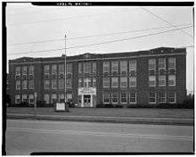
 City Hall and Municipal building | |
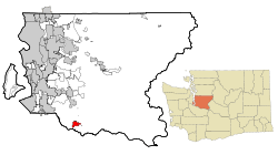 Location of Enumclaw within King County, Washington | |
| Coordinates: 47°12′09″N 121°59′39″W / 47.20250°N 121.99417°WCoordinates: 47°12′09″N 121°59′39″W / 47.20250°N 121.99417°W | |
| Country | United States |
| State | Washington |
| County | King |
| Government | |
| • Mayor | Jan Molinaro |
| Area[1] | |
| • Total | 4.27 sq mi (11.06 km2) |
| • Land | 4.26 sq mi (11.03 km2) |
| • Water | 0.01 sq mi (0.03 km2) |
| Elevation | 761 ft (232 m) |
| Population (2010)[2] | |
| • Total | 10,669 |
| • Estimate (2015)[3] | 11,609 |
| • Density | 2,504.5/sq mi (967.0/km2) |
| Time zone | UTC−8 (Pacific) |
| • Summer (DST) | UTC−7 (Pacific) |
| ZIP code | 98022 |
| Area code(s) | 360 |
| FIPS code | 53-22045 |
| GNIS feature ID | 1519366[4] |
| Website | www.cityofenumclaw.net |
Enumclaw (/ˈiːnəmklɔː/ (![]()
The Enumclaw Plateau, on which the city resides, was formed by a volcanic mudflow (lahar) from Mount Rainier approximately 5,700 years ago.[6]
The name Enumclaw is derived from a Salish Native American term that translates as "place of evil spirits", apparently referring to Enumclaw Mountain, located about 6 miles (9.7 km) to the north, and referring either to some evil incident that occurred there or to the occasional powerful windstorms from the east that affect the region.[7][8] Native American mythology tells the story of two Pacific Northwest Native American brothers – Enumclaw and Kapoonis – whose father turned them into thunder and lightning respectively. The City of Enumclaw says the name means "thundering noise".[9]
History
One of the first white settlers in south King County was Allen L. Porter. In 1853, he claimed a 320-acre (1.3 km2) parcel on the White River, about three miles (5 km) west of the site of Enumclaw. He maintained a troubled relationship with the local Smalkamish tribe (some of the ancestors of the Muckleshoot tribe) for some time, and in 1855 his cabin was burned to the ground. Porter, who had been warned in advance by a friend in the tribe, hid in the woods until they had left. After warning the settlers at Fort Steilacoom, he left the area, moving to Roy. He would never return to Enumclaw.
Enumclaw itself was homesteaded in 1879 by Frank and Mary Stevenson. In 1885, the Northern Pacific Railroad routed their transcontinental mainline through the site, accepting their offer of cleared, level land on which to build a siding. Confident that the area would grow, the Stevensons filed a plat with King County that same year. They built a hotel and gave away lots for a saloon and a general store.
At first the people called the town 'Stevensonville' after the founders, but they soon refused the honor. One resident suggested 'Enumclaw,' which was the name of the strange sawed-off promontory north of town. The name's uniqueness gained favor with the locals.
On January 11, 1895 Mount Baldy, a small peak above the town, "erupted" with tremendous fire and smoke, although no losses or damage were reported, and the conflagration was minimized by residents.[10] Throughout the 1880s and 1890s the area was farmed for hops. When the hops crop failed due to pests and economic downturn, the residents turned to dairy farming, which has been a mainstay ever since. The first census listing Enumclaw in 1900 put the population at 483 people.
In the 1890s, the Northern Pacific Railroad re-routed their line through Palmer, a few miles to the east of town. In 1910, the Chicago, Milwaukee, St. Paul and Pacific Railroad routed a branch line through Enumclaw.
The city was incorporated on January 27, 1913. In 1929, a much-anticipated route to Eastern Washington was opened across the Naches Pass Highway. In the 1950s Enumclaw Insurance Group greatly expanded its business and the home office became a major employer in the town. The company is an insurer doing business in Washington, Oregon, Idaho and Utah.
In 2005 the Enumclaw horse sex case occurred on a farm five miles (8 km) northwest of Enumclaw, in unincorporated King County.[11] A Boeing aerospace engineer named Kenneth Pinyan from Gig Harbor, WA died after receiving anal sex from a horse.[12] The case and the surrounding media attention, led to Washington State banning bestiality.[13] As of 2015, according to journalist Charles Mudede, people in Enumclaw generally do not wish to acknowledge the incident and that it had deeply upset area horse owners.[14]
Business
Enumclaw has resisted the temptation of big box stores in an effort to maintain its livable, bucolic image. Its downtown is filled with small local shops, many restaurants and services. At least five major employers have chosen Enumclaw for their headquarters: Helac Corp, Mutual of Enumclaw, Nor-Pac Seating, Nether Industries, and Hill AeroSystems. Enumclaw has no B & O tax and Enumclaw enjoys one of the low sales tax rates in Washington state. Enumclaw has opted not to be part of the Regional Transit Authority (RTA) that covers much of King, Pierce and Snohomish counties; this reduces Enumclaw's sales tax rate, car tab fees and property taxes-saving local businesses and residents thousands of dollars and making Enumclaw very competitive.
Tourism
Enumclaw is the gateway to Mount Rainier National Park and is the closest city to Washington State's premier ski area, Crystal Mountain. Enumclaw is also the start of the Chinook Scenic Byway. Enumclaw provides Summer and Fall access to Washington's wine country (Yakima) via Chinook Pass. Enumclaw has three state parks (Nolte, Flaming Geyser, Kanaskat Palmer) within 15 minutes as well as the Federation Forest. The Enumclaw Plateau is home to many horse and cattle farms. Enumclaw has the most dairy farms in production (16 Grade "A") within the King and Pierce County region. Enumclaw City Council has an Economic Development Committee and the city has a sanctioned Tourism Board.
Crime
According to the FBI's latest crime report (2017 data, issued in 2018), out of 281 cities in Washington State, Enumclaw is the 18th safest city for violent and property crimes.
Geography
Enumclaw is located at 47°12′9″N 121°59′39″W / 47.20250°N 121.99417°W (47.202401, -121.994044).[15]
The city is located in the midst of flat, level farmlands and dairy farms in the east Puget Sound lowlands. The flat geography in the middle of mountainous territory is due to the ancient Osceola Mudflow from nearby Mount Rainier.
The city is unique in the fact that it is landlocked by farm preservation on three sides[16] and protected forest lands to the east.[17] The city is nestled against the Cascade foothills.
According to the United States Census Bureau, the city has a total area of 4.27 square miles (11.06 km2), of which, 4.26 square miles (11.03 km2) is land and 0.01 square miles (0.03 km2) is water.[1]
While Enumclaw is entirely located in King County, the city owns some park property within the boundaries of Pierce County.[18]
Climate
This region experiences very warm (but not hot) and dry summers, with no average monthly temperatures above 71.6 °F (22 C) . According to the Köppen Climate Classification system, Enumclaw has a warm-summer Mediterranean climate, abbreviated "Csb" on climate maps.[19] In comparison, Enumclaw is typically warmer than Seattle by about 5 to 10 degrees Fahrenheit during the summer and cooler in the winter by about 5 to 10 degrees Fahrenheit. On average, Enumclaw experiences two to three wind storms per year that last up to 3 days each. These wind storms usually produce a constant wind out of the east at 20 to 30 mph (9 m/s, 32 km/h) and gusts as high as 60 mph (27 m/s, 96.5 km/h). Enumclaw city center is at 750 feet (228 m) above sea level. The higher elevation allows Enumclaw to experience sunshine when most of the Puget Sound region is shrouded in fog and of course more snow than Seattle.
Demographics
| Historical population | |||
|---|---|---|---|
| Census | Pop. | %± | |
| 1900 | 483 | — | |
| 1910 | 1,129 | 133.7% | |
| 1920 | 1,378 | 22.1% | |
| 1930 | 2,084 | 51.2% | |
| 1940 | 2,627 | 26.1% | |
| 1950 | 2,789 | 6.2% | |
| 1960 | 3,269 | 17.2% | |
| 1970 | 4,703 | 43.9% | |
| 1980 | 5,427 | 15.4% | |
| 1990 | 7,227 | 33.2% | |
| 2000 | 11,116 | 53.8% | |
| 2010 | 10,669 | −4.0% | |
| Est. 2016 | 11,654 | [20] | 9.2% |
| U.S. Decennial Census[21] 2015 Estimate[3] | |||
In the year 2000, the center of population of Washington State was located in an unincorporated part of King County, just northeast of town.[22]
2010 census
As of the census[2] of 2010, there were 10,669 people, 4,420 households, and 2,793 families residing in the city. The population density was 2,504.5 inhabitants per square mile (967.0/km2). There were 4,683 housing units at an average density of 1,099.3 per square mile (424.4/km2). The racial makeup of the city was 91.8% White, 0.5% African American, 1.0% Native American, 0.9% Asian, 0.1% Pacific Islander, 2.9% from other races, and 2.7% from two or more races. Hispanic or Latino of any race were 6.6% of the population.
There were 4,420 households of which 32.9% had children under the age of 18 living with them, 45.9% were married couples living together, 12.4% had a female householder with no husband present, 4.8% had a male householder with no wife present, and 36.8% were non-families. 30.8% of all households were made up of individuals and 14% had someone living alone who was 65 years of age or older. The average household size was 2.39 and the average family size was 3.00.
The median age in the city was 38.9 years. 24.5% of residents were under the age of 18; 8.8% were between the ages of 18 and 24; 24.8% were from 25 to 44; 26.9% were from 45 to 64; and 14.9% were 65 years of age or older. The gender makeup of the city was 47.8% male and 52.2% female.
2000 census
As of the census of 2000, there were 11,116 people, 4,317 households, and 2,840 families residing in the city. The population density was 2,842.8 people per square mile (1,097.7/km²). There were 4,456 housing units at an average density of 1,139.6 per square mile (440.0/km²). The racial makeup of the city was 94.25% White, 0.79% Native American, 0.78% Asian, 0.30% African American, 0.11% Pacific Islander, 1.15% from other races, and 2.62% from two or more races. Hispanic or Latino of any race were 3.42% of the population. 16.6% were of German, 11.3% Irish, 10.3% English, 9.0% American, 7.6% Norwegian, and 5.9% Italian ancestry.
There were 4,317 households out of which 37.5% had children under the age of 18 living with them, 50.0% were married couples living together, 11.2% had a female householder with no husband present, and 34.2% were non-families. 29.3% of all households were made up of individuals and 14.0% had someone living alone who was 65 years of age or older. The average household size was 2.52 and the average family size was 3.13.
In the city, the population was spread out with 29.2% under the age of 18, 7.6% from 18 to 24, 30.3% from 25 to 44, 18.3% from 45 to 64, and 14.5% who were 65 years of age or older. The median age was 35 years. For every 100 females, there were 91.5 males. For every 100 females age 18 and over, there were 85.3 males.
The median income for a household in the city was $58,019 in 2013. The average household income in the 98022 Enumclaw retail trade (draw) area was $89,481 in 2013. The per capita income for the city was $20,596. About 4.3% of families and 8.2% of the population were below the poverty line, including 6.3% of those under age 18 and 9.6% of those age 65 or over. Unemployment was at 4.30% in 2016 with 2313 blue collar workers and 4051 white collar workers.
Government and infrastructure
Enumclaw is one of just three cities in Washington with breed-specific legislation banning pit bull dogs within the city limits.[23] Enumclaw has also chosen to ban the production, distribution and sale of recreational marijuana.
Enumclaw operates with a strong Mayor / Council form of government. The City of Enumclaw operates its own solid waste utility (garbage), water, stormwater and sewer departments. The city is unique as it is just one of two cities in Washington state that owns its natural gas company. In 2015 residents voted in a 1/10 of 1% sales tax increase to repair and maintain local streets. Street repairs have started (Spring 2017) and will continue over the next five years.
The United States Postal Service operates the Enumclaw Post Office and a regional distribution center.[24] Enumclaw is also home to a detachment for the Washington State Patrol (WSP), the U.S. Forest Service, the Department of Natural Resources and the Washington State Department of Transpotation (WSDOT).
Media
The town is home to the Courier-Herald newspaper. Enumclaw is also home to KGRG (1330 AM), a 500 watt AM college radio station licensed to the Green River Foundation and operated by Green River Community College in Auburn, as well as the non-profit 501(c)3 media studio Knok Studio.
Health care
St. Elizabeth Hospital, part of the Franciscan Health System (a five-hospital organization based in Tacoma), is located in Enumclaw.[25] St. Elizabeth Hospital was included on the 2011 list of the 25 "Most Wired" small and rural hospitals in the nation for its use of information technology to support quality patient care and achieve operational efficiencies.[26] It replaced the former Enumclaw Community Hospital in 2011.[14]
Parks and recreation
The Enumclaw Expo Center annually hosts the King County Fair and the Pacific Northwest Scottish Highland Games,[27] among a number of other exhibitions and festivals. The Olympic Kennel Club has the 5th largest dog show in the nation each year in August. The 72-acre (29 ha) facility has many areas that are available to rent for weddings, trade shows, conventions and other special events.
Education
The Enumclaw School District operates public schools for students living in the Enumclaw, Black Diamond, Seleck, Palmer, Ravensdale and Greenwater areas. Elementary schools in Enumclaw and serving portions of Enumclaw include Byron Kibler, Southwood, Sunrise, and Westwood. Some portions of Enumclaw are zoned to Enumclaw Middle School in Enumclaw, while some portions are zoned to Thunder Mountain Middle School in unincorporated King County.[28] All residents of Enumclaw are zoned to Enumclaw High School. Green River Community College operates a campus in Enumclaw. Schooldigger.com ranks Enumclaw 41th of the 205 school districts (top 20%) in the State and shows an improving trend.
Notable people
- Jeff Hougland, UFC fighter, Founder of Combat Sport and Fitness
- Kasey Kahne, NASCAR driver
- Richard Kovacevich, Chairman of the board of directors of Wells Fargo & Company
- Swen Nater, retired professional basketball player who won rebounding titles in both the ABA and NBA
- Brian Scalabrine, retired basketball player, formerly of the NBA's Boston Celtics and Chicago Bulls
- Tony Tost, poet
Popular culture
The 1967 Walt Disney film, Charlie, the Lonesome Cougar, was filmed at the Weyerhauser Mill in Enumclaw and surrounding areas.
References
- 1 2 "US Gazetteer files 2010". United States Census Bureau. Archived from the original on 2012-01-24. Retrieved 2012-12-19.
- 1 2 "American FactFinder". United States Census Bureau. Retrieved 2012-12-19.
- 1 2 "Population Estimates". United States Census Bureau. Archived from the original on October 19, 2016. Retrieved June 25, 2015.
- ↑ "Enumclaw". Geographic Names Information System. United States Geological Survey.
- ↑ "2010 Census Redistricting Data (Public Law 94-171) Summary File". American FactFinder. United States Census Bureau. Archived from the original on 21 July 2011. Retrieved 10 September 2012.
- ↑ "About Buckley". Cityofbuckley.com. Archived from the original on 2011-09-27. Retrieved 2011-11-18.
- ↑ Brokenshire, Doug (1993). Washington State Place Names: From Alki to Yelm. Caxton Press. p. 70. ISBN 978-0-87004-356-7. Retrieved 11 December 2010.
- ↑ Mass, Cliff (2008). The Weather of the Pacific Northwest. University of Washington Press. pp. 160–162. ISBN 978-0-295-98847-4.
- ↑ Visitor Information Archived 2012-11-28 at the Wayback Machine., City of Enumclaw
- ↑ "Newspaper reports eruption of Mount Baldy on January 10, 1895. - HistoryLink.org".
- ↑ Rick Anderson (November 9, 2005). "Closing the Barn Door". Seattle Weekly. "Tait, a truck driver who lives near the Southeast 444th Street farm where the death occurred, "
- ↑ Lewis, Gerrick. "Movie tracks man's mysterious death Archived 2011-01-17 at the Wayback Machine.." The Lantern. Monday April 2, 2007. Updated on Saturday June 20, 2009. Retrieved on October 9, 2010.
- ↑ Mudede, Charles (February–March 2006). "The Animal In You". The Stranger. Retrieved 2006-04-30.
- 1 2 Mudede, Charles (2015-07-22). "Revisiting the Town of the Most Famous Horse Sex Death in Recorded History". The Stranger. Retrieved 2017-11-14.
- ↑ "US Gazetteer files: 2010, 2000, and 1990". United States Census Bureau. 2011-02-12. Retrieved 2011-04-23.
- ↑ "Farmland Preservation Program - King County".
- ↑ "Washington Forest Protection Association — One Voice Blog". Archived from the original on 2015-12-19.
- ↑ Pierce County Profile, Section 2 Archived 2008-09-10 at the Wayback Machine., 2-7.
- ↑ "Enumclaw, Washington Köppen Climate Classification (Weatherbase)".
- ↑ "Population and Housing Unit Estimates". Retrieved June 9, 2017.
- ↑ United States Census Bureau. "Census of Population and Housing". Archived from the original on May 12, 2015. Retrieved July 25, 2013.
- ↑ "Population and Population Centers by State: 2001". U.S. Census Bureau. Archived from the original on 2001-12-12. Retrieved 2007-06-15.
- ↑ "Chapter 7.08 PIT BULL DOGS". Codepublishing.com. Retrieved 2011-11-18.
- ↑ "Post Office Location - ENUMCLAW Archived 2012-07-16 at Archive.is." United States Postal Service. Retrieved on September 28, 2010.
- ↑ "Hospital to operate under new name - Enumclaw Courier-Herald". Pnwlocalnews.com. 2010-09-20. Archived from the original on 2012-09-09. Retrieved 2011-11-18.
- ↑ "St. Elizabeth Hospital Is Among 'Most Wired' In Nation". Franciscan Health System. 2011-07-21. Archived from the original on 2014-01-06. Retrieved 2014-01-05.
- ↑ "Seattle Scottish Highland Games Association". Sshga.org. Retrieved 2011-11-18.
- ↑ "Boundary Map." Enumclaw School District. Retrieved on September 28, 2010.
External links
| Wikimedia Commons has media related to Enumclaw, Washington. |
- City of Enumclaw website
- Visit Enumclaw (City of Enumclaw tourism website)
- Enumclaw Courier-Herald
- Enumclaw Area Chamber of Commerce
- St. Elizabeth Hospital
- Enumclaw Rotary Club
- Enumclaw Heritage
- Enumclaw School District
Municipalities and communities of King County, Washington, United States | ||
|---|---|---|
| Cities |
|  |
| Towns | ||
| CDPs |
| |
| Unincorporated communities | ||
| Indian reservation | ||
| Ghost towns | ||
| Footnotes | ‡This populated place also has portions in an adjacent county or counties | |