Melrose–Rugby Historic District
|
Melrose–Rugby Historic District | |
 | |
  | |
| Location | Mercer, Grayson, & Carroll Aves., NW., Rugby Blvd., NW., 10th, 11th, 12th, 13th & 14th Sts., NW., Roanoke, Virginia |
|---|---|
| Coordinates | 37°17′11″N 79°57′17″W / 37.28639°N 79.95472°WCoordinates: 37°17′11″N 79°57′17″W / 37.28639°N 79.95472°W |
| Area | 57.7 acres (23.4 ha) |
| Built | c. 1916-1949 |
| Architectural style | Bungalow/Craftsman, American Foursquare, Cape Cod |
| NRHP reference # | 13000645[1] |
| VLR # | 128-6261 |
| Significant dates | |
| Added to NRHP | August 27, 2013 |
| Designated VLR | June 19, 2013[2] |
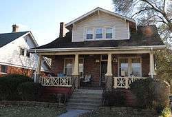
Melrose–Rugby Historic District is a national historic district located in the Melrose–Rugby neighborhood of Roanoke, Virginia. It encompasses 111 contributing buildings and 2 contributing objects in a planned residential subdivision, with most of the dwellings being built between the late 1910s and late 1940s. It is a primarily residential district with single-family dwellings. The houses include American Craftsman-style bungalow, American Foursquare, and Cape Cod style.[3]
It was listed on the National Register of Historic Places in 2013.[1]
References
- 1 2 "National Register of Historic Places Listings 8/23/13 through 8/30/13". Weekly List of Actions Taken on Properties. National Park Service. 2013-09-06.
- ↑ "Virginia Landmarks Register". Virginia Department of Historic Resources. Retrieved 19 March 2013.
- ↑ Alison S. Blanton, Patrick Hughes and Katherine Coffield (March 2013). "National Register of Historic Places Inventory/Nomination: Melrose–Rugby Historic District" (PDF). Virginia Department of Historic Resources. and Accompanying six photos and Accompanying map


This article is issued from
Wikipedia.
The text is licensed under Creative Commons - Attribution - Sharealike.
Additional terms may apply for the media files.