Carillon Neighborhood Historic District
|
Carillon Neighborhood Historic District | |
 | |
  | |
| Location | Belmont, Blanton, Maplewood, Rendale & Sunset Aves., Carrolton, Condie, French, Garrett, Rueger & Sheppard Sts., Richmond, Virginia |
|---|---|
| Coordinates | 37°32′37″N 77°29′04″W / 37.54361°N 77.48444°WCoordinates: 37°32′37″N 77°29′04″W / 37.54361°N 77.48444°W |
| Area | 57 acres (23 ha) |
| NRHP reference # | 15001045[1] |
| VLR # | 127-6756 |
| Significant dates | |
| Added to NRHP | February 2, 2016 |
| Designated VLR | December 10, 2015[2] |
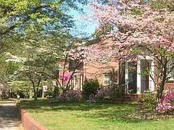
The Carillon Neighborhood Historic District encompasses a residential area of western Richmond, Virginia. It is located about 3 miles (4.8 km) west of downtown Richmond, and is roughly bounded on the north and west by the Powhite Expressway and the Downtown Expressway, on the south by the Kanawha Canal, and on the east by Byrd Park. Although this area has a residential history dating into the 19th century (when it was home mainly to country estates), its present architecture is reflective of its development first as a streetcar suburb, and then as a post-World War II housing development area.[3]
The district was listed on the National Register of Historic Places in 2016.[1]
See also
References
- 1 2 National Park Service (2010-07-09). "National Register Information System". National Register of Historic Places. National Park Service.
- ↑ "Virginia Landmarks Register". Virginia Department of Historic Resources. Retrieved 2016-05-04.
- ↑ "NRHP nomination for Carillon Neighborhood Historic District" (PDF). Virginia DHR. Retrieved 2016-05-04.
| Wikimedia Commons has media related to Carillon Neighborhood Historic District. |


This article is issued from
Wikipedia.
The text is licensed under Creative Commons - Attribution - Sharealike.
Additional terms may apply for the media files.