List of state trunk highways in Wisconsin
| Wisconsin State Trunk Highways | |
|---|---|
  | |
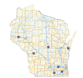 Map of the Wisconsin highway system | |
| System information | |
| Notes | Wisconsin Highways are generally state-maintained. |
| Highway names | |
| Interstates | Interstate X (I-X) |
| US Highways | U.S. Highway X (US X) |
| State | (State Trunk) Highway X (STH-X or WIS X) |
| System links | |
The organized system of Wisconsin State Trunk Highways (typically abbreviated as STH or WIS), the state highway system for the U.S. state of Wisconsin, was created in 1917. The legislation made Wisconsin the first state to have a standard numbering system for its highways. It was designed to connect every county seat and city with over 5000 residents. The original system numbered the roads starting at 11 and ran up to 199. The 1917 law required the creation of a distinctive state route marker, which was initially an inverted triangle. "...it soon became apparent that (the triangle) served no really useful purpose after the public had become educated to the idea of the numbering. The long vertical axis made it necessary to use a lot of space, much of which was useless."[1] Distinctive route markers were eventually redesigned to use a rounded rectangle for better space usage, but the inverted triangle remains transposed, as a vestige.[1]
These routes were altered significantly in 1926 when United States Numbered Highways were commissioned. It was altered to include communities with at least 2,500 residents.[2] Further alteration occurred when the Interstate Highway System was commissioned in the state.[3]
Wisconsin highway markers use the FHWA Highway Gothic font in Series D for all one- and two-digit numbers and Series C for three-digit markers. All highways except Interstates use 24-by-24-inch (610 mm × 610 mm) or 36-by-36-inch (910 mm × 910 mm) markers; Interstate markers for three-digit highways are wider shields.[4]

Mainline highways
| Number | Length (mi) | Length (km) | Southern or western terminus | Northern or eastern terminus | Formed | Removed | Notes | |
|---|---|---|---|---|---|---|---|---|
| 316.51 | 509.37 | Beloit | Superior | 1918 | 1926 | Now US 2 and US 51 | ||
| 316.51 | 509.37 | Madison | La Crosse | 1918 | 1933 | Now US 14; replaced by WIS 35, US 61 and WIS 27 west of Viroqua in 1926, and US 63 north of Viroqua in 1926; extended over WIS 41 to Madison in 1926. | ||
| 157.56 | 253.57 | US 61/US 151/WIS 35 in Kieler | WIS 32 in Racine | — | — | |||
| 339.40 | 546.21 | I-94/US 12 in Hudson | US 12 in Genoa City | 1918 | 1926 | Now US 12 | ||
| 338.32 | 544.47 | I-90/I-94 in Wisconsin Dells | US 2/US 53 in Superior | — | — | Forms a part of the Lake Superior Circle Tour | ||
| 198.49 | 319.44 | St. Croix Falls | Armstrong Creek | 1918 | 1926 | Now US 8 | ||
| — | — | Milwaukee | Iowa | 1926 | 1933 | former WIS 61; became WIS 81 and WIS 15 (now completely supplanted by I-43) because of the extension of US 14 into Wisconsin. | ||
| — | — | Illinois | Milwaukee | 1926 | 1932 | north of Milwaukee transferred to US 41 in 1926; replaced by WIS 42 (now completely supplanted by WIS 32) | ||
| — | — | Milwaukee | Beloit | 1933 | 1987 | replaced by I-43 | ||
| 14.80 | 23.82 | US 45 in New London | US 41 in Appleton | 1996 | current | not open until 1998 | ||
| — | — | Manitowoc | Chippewa Falls | 1918 | 1926 | now US 141 and rest renumbered WIS 29 | ||
| 193.2 | 310.9 | US 14/US 61 in La Crosse | I-94 in Waukesha | — | — | Previously US 16 | ||
| 85.63 | 137.81 | WIS 64 in Illinois | Sister Bay | — | 1932 | transferred to US 141, US 41, and WIS 42 (now completely supplanted by WIS 32) | ||
| 85.63 | 137.81 | WIS 64 in Merrill | FFH-16 in Phelps | 1934 | current | |||
| 182.16 | 293.16 | Minnesota | Manitowoc | 1918 | 1926 | Replaced by US 10 and rest renumbered WIS 34 | ||
| 59.37 | 95.55 | US 14/WIS 78 in Mazomanie | WIS 16 in Watertown | — | — | East of Watertown now WIS 16, US 151, and US 18 | ||
| 42.95 | 69.12 | US 12/WIS 67 in LaGrange | WIS 32 in Racine | — | — | |||
| 123.37 | 198.54 | WIS 16/WIS 27/WIS 71 in Sparta | US 45 in Oshkosh | — | — | |||
| 172.18 | 277.10 | US 51/WIS 60 in Arlington | US 41 in Oconto | — | — | |||
| 211.05 | 339.65 | WIS 11 & CTH-P in Shullsburg | WIS 28/WIS 42 in Sheboygan | — | — | originally went southwest via current US 151 before 1926 instead of south; | ||
| 7.88 | 12.68 | CTH-P in Hales Corners | WIS 241 in Milwaukee | — | — | originally ended in East Troy at WIS 20 | ||
| 85.81 | 138.10 | MN 60 in Nelson | WIS 48 in Rice Lake | — | — | |||
| 98.15 | 157.96 | US 51 in Janesville | US 41 & CTH-N in Oshkosh | — | — | |||
| 294.08 | 473.28 | US 18/WIS 60 in Prairie du Chien | US 2 in Brule | — | — | originally went west on current WIS 77 to Minnesota | ||
| 59.77 | 96.19 | WIS 33 in Horicon | WIS 23/WIS 42 in Sheboygan | — | — | |||
| — | — | Watertown | Minnesota State Line | 1918 | 1926 | replaced by US 16; now WIS 16 | ||
| 307.35 | 494.63 | US 10/WIS 35 in Prescott | WIS 42 in Kewaunee | — | — | former WIS 16 and WIS 146 | ||
| 3.43 | 5.52 | US 151 in Madison | I-39/I-90/I-94 in Madison | — | — | |||
| — | — | Illinois | Manitowoc | 1918 | 1934 | south end truncated to Fond du Lac in 1926, replaced by WIS 69 and US 151 south of Fond du Lac. Rest replaced by US 151 in 1934. | ||
| 22.86 | 36.79 | IL 131 in Pleasant Prairie | WIS 32 in Caledonia | 1936 | current | |||
| 325.69 | 524.15 | IL 137 in Pleasant Prairie | US 45 at Land O' Lakes | — | — | 32nd Division Memorial Highway[5] | ||
| 200.84 | 323.22 | US 14/US 61 in La Crosse | WIS 32 in Port Washington | — | — | |||
| 14.19 | 22.84 | Berlin | Butte des Morts | 1918 | 1926 | renumbered WIS 16 | ||
| 22.86 | 36.79 | WIS 13/WIS 73 in Wisconsin Rapids | I-39US 51 in Knowlton | — | — | former WIS 18 | ||
| 412.15 | 663.29 | IL 35 in Kieler | I-535/US 53 in Superior | — | — | south of Kieler replaced by US 61 in 1926. | ||
| 35.89 | 57.76 | WIS 120 in Springfield | WIS 241 in Milwaukee | — | — | |||
| 42.67 | 68.67 | WIS 35 in Alma | US 12 in Eau Claire | — | — | |||
| 25.33 | 40.76 | WIS 32 in Racine | WI 59 in Milwaukee | — | — | |||
| 43.02 | 69.23 | US 18 in Edmund | WIS 69 in New Glarus | — | — | |||
| 81.56 | 131.26 | US 12/WIS 29 in Elk Mound | WIS 27/WIS 70 in Radisson | — | — | |||
| 144.00 | 231.75 | Milwaukee | Minnesota | 1918 | 1926 | Became US 18, WIS 11 (now US 14), and US 61 | ||
| 137.76 | 221.70 | WIS 23/W 28 in Sheboygan | Northport | — | — | |||
| 316.51 | 509.37 | — | — | 1918 | 1923 | Now WIS 27 | ||
| 316.51 | 509.37 | — | — | 1923 | 1974 | Now WIS 142 | ||
| 63.86 | 102.77 | WIS 22 in Pardeeville | US 45 in Oshkosh | — | — | |||
| — | — | Minnesota state line at Red Wing | Ellsworth | 1918 | 1923 | Became WIS 35 (now US 63) | ||
| — | — | Wisconsin Rapids | Knowlton | 1923 | 1934 | Became WIS 34 | ||
| 34.13 | 54.93 | US 63/WIS 64 in Deer Park | WI 35 in Milltown | — | — | |||
| 188.01 | 302.57 | WIS 114 in Menasha | US 51/WIS 182 in Manitowish | — | — | |||
| 98.19 | 158.02 | WIS 70/WIS 87 in Grantsburg | WIS 40 in Exeland | — | — | |||
| 127.52 | 205.22 | US 41 & CTH-KK in Lomira | WIS 29 in Elderon | — | — | |||
| 44.43 | 71.50 | WIS 11 in Delavan | WIS 32 in Kenosha | — | — | |||
| — | — | Turtle Lake | Spooner | 1918 | 1923 | Became an extension of WIS 24 (now US 63) | ||
| — | — | Ellsworth | Downsville | 1923 | 1926 | Renumbered WIS 72 because of US 51 | ||
| 74.91 | 120.56 | US 51/WIS 29 in Wausau | WIS 32 in Wabeno | — | — | |||
| 45.80 | 73.71 | Whitehall | Neillsville | 1918 | 1926 | renumbered WIS 95 because of US 53 (one part later WIS 121) | ||
| 243.12 | 391.26 | MN 43 in Marshland | WIS 42 in Algoma | — | — | |||
| 175.55 | 282.52 | US 151 in Brothertown | M-73 in Nelma | — | — | one section transferred to WIS 165 (now supplanted by realgined US 41/US 45) in 1926, and sections to US 151 and US 45 in 1934, and one separated section was renumbered WIS 145. | ||
| 50.56 | 81.37 | WIS 35 in Genoa | WIS 80 in Richland Center | — | — | |||
| 191.82 | 308.70 | WIS 59 in Milwaukee | WIS 42 in Sister Bay | — | — | south of Milwaukee replaced by US 41 in 1926. | ||
| 53.92 | 86.78 | US 14 in Richland Center | WIS 80 in Necedah | — | — | |||
| 116.21 | 187.02 | WIS 11/WIS 81 in Monroe | WIS 32 in Milwaukee | — | — | |||
| 185.08 | 297.86 | US 18 in Prairie du Chien | I-43/WIS 32/WS 57 in Grafton | — | — | |||
| — | — | — | — | 1918 | 1926 | Became WIS 14 because of US 61, later WIS 81 and WIS 15 (because of US 14 extension) (now supplanted by I-43) | ||
| — | — | Milwaukee | Milwaukee | — | 1999 | |||
| — | — | Merrill | Eagle River | — | 1934 | Renumbered WIS 17 because of US 63 | ||
| 275.65 | 443.62 | MN 36 in Houlton | US 41 in Marinette | — | — | |||
| 54.12 | 87.10 | US 10/US 63 in Ellsworth | US in St. Croix Falls | — | — | |||
| 18.73 | 30.14 | WIS 34 in Wisconsin Rapids | WIS 49 in Rosholt | — | — | |||
| 160.11 | 257.67 | IL 75 in Beloit | US 151 in Valders | — | — | |||
| 9.51 | 15.30 | WIS 33 in Fox Lake | WIS 49 in Waupun | — | — | |||
| — | — | Michigan | Michigan | 1918 | 1926 | replaced by US 2 | ||
| 40.78 | 65.63 | IL 26 at Monroe | US 18/US 151 in Verona | 1926 | current | former portion of WIS 31 | ||
| 246.49 | 396.69 | MN 70 at Grantsburg | US 2/US 141 & WIS 101 in Florence | — | — | |||
| 53.55 | 86.18 | WIS 54/WIS 108 in Melrose | WIS 80/WIS 82 in Elroy | — | — | |||
| 29.44 | 47.38 | west of Eagle River | Plum Lake | — | — | renumbered WIS 155 | ||
| 29.44 | 47.38 | US 10/US 63 in Ellsworth | WIS 25 in Downsville | — | — | former WIS 51 | ||
| 265.84 | 427.83 | I-39/I-90/US 51 in Edgerton | US 8 in Ingram | — | — | |||
| 11.68 | 18.80 | WIS 190 in Pewaukee | US 41/US 45/WIS 100 in Menomonee Falls | 1917 | 2015 | Extension of CTH-F and local roads | ||
| 12.10 | 19.47 | WIS 50/WIS 83 in Paddock Lake | WIS 20 in Waterford | — | — | |||
| 43.40 | 69.85 | US 45 in Oshkosh | US 45/WIS 22 in Bear Creek | — | — | |||
| 139.94 | 225.21 | MN 48 at Danbury | BUS US 2 at Hurley | — | — | |||
| 92.83 | 149.40 | IL 78 in Gratiot | I-39/I-90/I-94 in Portage | — | — | |||
| 17.63 | 28.37 | US 12 in Menomonie | WIS 64 in Connorsville | — | — | |||
| 163.23 | 262.69 | IL 84 in Hazel Green | US 10 in Marshfield | — | — | |||
| 123.81 | 199.25 | WIS 133 in Cassville | I-39/I-90 & I-43 in Beloit | — | — | |||
| 116.15 | 186.93 | Iowa 9 at DeSoto | I-39/US 51/WIS 23 in Oxford | — | — | |||
| 74.52 | 119.93 | IL 83 in Paddock Lake | WIS 175 in Hartford | — | — | |||
| 18.60 | 29.93 | WIS 32 in Port Washington | WIS 28/WIS 144 in Boltonville | — | 1990 | Now county highways | ||
| 23.48 | 37.79 | US 10/WIS 25 in Durand | WIS 37 in Eau Claire | — | — | |||
| 32.32 | 52.01 | WIS 13 in Ogema | US 51 & CTH-D in Tomahawk | — | — | |||
| 25.82 | 41.55 | US 8 in St. Croix Falls | WIS 48/WIS 70 in Grantsburg | — | — | |||
| 29.75 | 47.88 | WIS 35 in Fountain City | WIS 37 in Mondovi | — | — | |||
| 29.75 | 47.88 | US 14/WIS 11 in Darien | WIS 73 in Columbus | — | — | |||
| 10.40 | 16.74 | WIS 16 in Ixonia | WIS 59 in Palmyra | — | 1974 | Became WIS 135, but that was eliminated in 1990 | ||
| 18.83 | 30.30 | WIS 49 in Berlin | US 41/WIS 44 in Oshkosh | — | — | |||
| 30.68 | 49.37 | US 14 in Brooklyn | WIS 78 in Mount Horeb | — | — | |||
| 68.00 | 109.44 | US 53/WIS 35 in Holmen | US 53 in Eau Claire | — | — | |||
| — | — | Elroy | — | — | — | |||
| 73.76 | 118.71 | Oshkosh | Fremont | — | — | replaced by US 110; now WIS 110 (which replaced US 110 in 1938), CTH-II, US 45, and CTH-S | ||
| 73.76 | 118.71 | WIS 35 in Fountain City | WIS 73 in Neillsville | — | — | |||
| 55.94 | 90.03 | US 10/WIS 110 in Fremont | I-43 & CTH-KB in Denmark | — | — | |||
| 36.11 | 58.11 | WIS 13 in Marshfield | WIS 64 in Goodrich | — | — | |||
| 16.20 | 26.07 | WIS 73 in Greenwood | WIS 13 in Spencer | — | — | |||
| — | — | WIS 67 near Eagle | WIS 83 in Mukwonago | — | 1999 | |||
| 39.69 | 63.87 | WI 32 in Oak Creek | I-43/WIS 32 in Bayside | — | — | |||
| 23.54 | 37.88 | US 8 in Armstrong Creek | US 2/US 141 & WIS 70 in Florence | — | — | |||
| 18.25 | 29.37 | WIS 13 in Chelsea | WIS 86 in Spirit | — | — | |||
| — | — | WIS 49 south of Brandon | US 151 near Lamartine | — | 1997 | |||
| 15.36 | 24.72 | WIS 11 in Brodhead | WIS 92 in Brooklyn | — | — | |||
| 4.72 | 7.60 | MN 39 in Oliver | WIS 35 in Superior | — | — | |||
| 29.22 | 47.03 | Albion | WIS 59 in Palmyra | — | — | |||
| 56.23 | 90.49 | WIS 153 in Mosinee | CTH-S in Tomahawk | — | — | |||
| 19.08 | 30.71 | WIS 16 in West Salem | WIS 54/WIS 71 in Melrose | — | — | |||
| — | — | WIS 19 in Watertown | WIS 67 near Woodland | — | 1998 | |||
| — | — | Benoit | south of Barksdale | 1919 | 1926 | became part of WIS 112 | ||
| 37.44 | 60.25 | US 10/WIS 96 in Fremont | US 45 in Marion | 1938 | current | former US 110; extended over WIS 142 in 1960 | ||
| 10.61 | 17.08 | US 8 in Catawba | WIS 13 in Phillips | — | — | |||
| 12.58 | 20.25 | WIS 13 in Marengo | WIS 137 in Ashland | — | — | west end was at US 63; extended over WIS 110 to Benoit in 1926; swapped with WIS 118 south of Ashland in 1971 | ||
| 40.34 | 64.92 | US 151 in Madison | WIS 33 in Baraboo | — | — | |||
| 21.03 | 33.84 | US 41 in Neenah | WIS 32/WIS 57 in Hilbert | — | — | |||
| — | — | US 41 in Muscoda | Richland Center | 1919 | 1923 | Replaced by WIS 80 | ||
| 5.80 | 9.33 | WIS 60 near Hustisford | WIS 26 in Juneau | — | 2005 | former WIS 118; Now CTH-DJ | ||
| — | — | Chippewa Falls | Prescott | — | — | replaced by WIS 29 | ||
| 14.19 | 22.84 | WIS 91 in Waukau | US 45 in Butte des Morts | — | — | former WIS 34 | ||
| 5.79 | 9.32 | WIS 29/WIS 47/WIS 55 in Bonduel | WIS 22 in Cecil | — | — | |||
| — | — | west of Hustisford | Juneau | 1919 | 1926 | renumbered WIS 115 because of US 118 | ||
| 6.86 | 11.04 | US 63 in Benoit | WIS 112 in Ashland | — | — | |||
| 1.89 | 3.04 | I-94/US 41 in Milwaukee | WIS 38 in Milwaukee | — | — | Milwaukee Airport Spur | ||
| 21.34 | 34.34 | IL 47 in Genoa City | I-43 in East Troy | — | — | |||
| 45.07 | 72.53 | WIS 88 in Gilmanton | WIS 95 in Alma Center | — | — | |||
| 14.69 | 23.64 | WIS 77 in Upson | CR 505 at Saxon | — | — | |||
| 3.00 | 4.83 | CTH-DL at Devil's Lake State Park | WIS 33/WIS 113 in Baraboo | — | 2016 | Now CTH DL | ||
| 17.59 | 28.31 | US 53 in Lake Hallie | WIS 64 in Eagleton | — | — | |||
| — | — | US 41 in Ashland Junction | WIS 10 (later US 2; now CTH-G) | 1920 | 1925 | Replaced by WIS 112 | ||
| 2.62 | 4.22 | US 41 in Appleton | WIS 47 in Appleton | 1926 | current | College Avenue | ||
| 5.70 | 9.17 | WIS 81 in Belmont | US 151 & CTH-G in Belmont | — | — | |||
| 14.16 | 22.79 | WI 16 near Wisconsin Dells | I-39/WIS 16 in Portage | — | — | |||
| 27.04 | 43.52 | WIS 72 in Elmwood | WIS 64 in Forest | — | — | |||
| 2.69 | 4.33 | US 61/WIS 35/WIS 81 in Lancaster | US 61 in Lancaster | — | — | |||
| 31.40 | 50.53 | WIS 23 in Dodgeville | WIS 154 in Hill Point | — | — | |||
| 78.9 | 127.0 | WIS 60 in Wauzeka | US 12/WIS 16 in Tomah | — | — | |||
| — | — | US 18 | Mount Hope | — | 1992 | |||
| 91.07 | 146.56 | US 61/WIS 35 in Potosi | US 14/WIS 60/WIS 130 in Lone Rock | — | — | |||
| 2.85 | 4.59 | US 12/US 18 in Cambridge | CTH-O in London | — | — | |||
| 10.40 | 16.74 | Packwaukee | US 16 | — | 1974 | |||
| 10.40 | 16.74 | WIS 16 in Ixonia | US 18 in Sullivan | 1974 | 1990 | Now CTH-F | ||
| 19.05 | 30.66 | WIS 23/WIS 33 in Reedsburg | CTH-DL and Park Road at the entrance of Devil's Lake in Baraboo | — | — | |||
| 6.25 | 10.06 | US 2 in Moquah | WIS 13 in Ashland | — | — | |||
| 13.23 | 21.29 | WIS 59 in Cooksville | US 14 in Oregon | — | — | |||
| 24.83 | 39.96 | US 8 in Cavour | M-189 at Tipler | — | — | |||
| 11.58 | 18.64 | IL 76 in Clinton | US 14/WIS 11 in Avalon | — | — | |||
| — | — | WIS 29 (now WIS 16) in Fall River | WIS 33 in Cambria | 1923 | 1926 | Renumbered WIS 146 because of US 141 | ||
| — | — | US 45 in Marion | US 10 in Weyauwega | — | 1960 | Became WIS 110 | ||
| 17.69 | 28.47 | WIS 11/WIS 36/WIS 83 in Burlington | I-41/I-94 & CTH-S in Kenosha | 1974 | current | |||
| — | — | US 45 in West Bend | Washington/Ozawkee Co | — | 1999 | |||
| 28.63 | 46.08 | WIS 175 in Slinger | WIS 57 in Random Lake | — | — | |||
| 23.87 | 38.42 | US 18 in Milwaukee | US 45 & CTH-FD in Germantown | — | — | |||
| — | — | Kewaunee | Bellevue | 1923 | 1926 | Replaced by WIS 29 | ||
| 13.22 | 21.28 | WIS 16 in Fall River | WIS 33 in Cambria | 1926 | current | Former WIS 141 | ||
| 15.09 | 24.29 | WIS 42 in Two Rivers | I-43 & CTH-Z in Maribel | — | — | |||
| — | — | Valders | Cato | — | — | Now CTH-J | ||
| — | — | US 151 in Peebles | WIS 32/WIS 57 in Kiel | — | 2006 | Now CTH-WH, CTH-G, and CTH-HH | ||
| — | — | WIS 110 west of Winchester | US 45 west of Neenah | — | 2003 | Decommissioned when the new US 45 freeway opened to traffic | ||
| — | — | Neenah | Appleton | — | 1926 | Renumbered WIS 125 because of US 141 | ||
| 7.22 | 11.62 | WIS 21/WIS 73 in Wautoma | CTH-G & CTH-W in Mt. Morris | — | — | |||
| 61.25 | 98.57 | WIS 13 in Spencer | US 45 in Tigerton | — | — | |||
| 22.54 | 36.27 | WIS 58 in Loyd | WIS 136 in Rock Springs | — | — | |||
| 6.94 | 11.17 | WIS 70 in St. Germain | CTH-N in Sayner | — | — | |||
| 26.72 | 43.00 | WIS 22 in Clintonville | WIS 29 in Angelica | — | — | |||
| 2.81 | 4.52 | WIS 35 in Onalaska | WIS 16 in La Crosse | — | — | |||
| 7.36 | 11.84 | I-41/I94 in Kenosha | 6th Avenue in Kenosha | — | — | |||
| 2.00 | 3.22 | US 12 in Baraboo | CTH-DL and Park Road at the entrance of Devil's Lake in Baraboo | — | 2017 | Now WIS 136 | ||
| 3.44 | 5.54 | WIS 29/WIS 55 in Angelica | WIS 32 in Pulaski | — | — | |||
| 22.42 | 36.08 | CTH-SS in Amherst Junction | WIS 22/WIS 110 in Symco | — | — | |||
| 46.03 | 74.08 | WIS 35 in Stoddard | WIS 71 in Four Corners | — | — | |||
| — | — | Mishicot | Luxemburg | — | 1999 | Now CTH-B and CTH-AB | ||
| 43.54 | 70.07 | WIS 36 in Waterford | WIS 60 in Slinger | — | — | |||
| 7.14 | 11.49 | I-41/I-94 & CTH-Q in Pleasant Prairie | WIS 32 in Pleasant Prairie | 1991 | current | Formerly CTH-Q | ||
| — | — | — | — | — | — | |||
| 24.96 | 40.17 | WIS 83 in Hartford | I-43/WIS 32/WIS 57 in Mequon | — | — | |||
| 5.93 | 9.54 | Nichols | Seymour | — | 2003 | Now CTH-VV | ||
| 17.36 | 27.94 | WIS 13 in Mellen | US 2 in Cedar | — | — | |||
| 23.98 | 38.59 | WIS 128 in Glenwood City | WIS 40 in Colfax | — | — | |||
| 33.39 | 53.74 | WIS 35 in Ferryville | US 14 in Boaz | — | — | |||
| 11.63 | 18.72 | WIS 54 in Hobart | I-43 in Bellevue | — | — | |||
| 36.85 | 59.30 | WIS 21 in Wyeville | WIS 73 in Nekoosa | — | — | |||
| 5.90 | 9.50 | WIS 31 in Pleasant Prairie | WIS 50 in Kenosha | — | 1991 | Now CTH-ML | ||
| 51.40 | 82.72 | WIS 59 in Milwaukee | US 151 in Fond du Lac | — | — | |||
| — | — | WIS 78 in Wiota | Illinois state line | — | 1999 | |||
| — | — | — | — | — | — | |||
| 23.30 | 37.50 | WIS 29 in Chippewa Falls | WIS 64 in Cornell | — | — | |||
| 8.80 | 14.16 | WIS 27 in Eastman | WIS 131 in Steuben | — | — | |||
| 30.42 | 48.96 | WIS 64 in Marinette | US 141 in Wausaukee | — | — | |||
| 21.44 | 34.50 | WIS 59 in West Allis | WIS 60 in Cedarburg | — | — | |||
| 33.41 | 53.77 | WIS 13 in Park Falls | US 51/WIS 47 in Manitowish | — | — | |||
| 35.3 | 56.8 | WIS 35 near Pepin | WIS 29 near Spring Valley | — | 1989 | Now CTH-CC | ||
| 12.04 | 19.38 | WIS 11 east of Footville | WIS 59 north of Fulton | — | 1999 | Now CTH-H | ||
| — | — | — | — | — | — | |||
| 15.01 | 24.16 | WIS 13/WIS 73 in Vesper | US 10 in Auburndale | — | — | |||
| 13.87 | 22.32 | WIS 54 in Shiocton | WIS 156 in Navarino | — | — | |||
| 11.88 | 19.12 | US 12 in Sauk City | WIS 113 in Harmony Grove | — | — | |||
| — | — | — | — | — | — | |||
| 19.58 | 31.51 | WIS 16 in Pewaukee | WIS 32 in Shorewood | — | — | |||
| 13.04 | 20.99 | WIS 23 in Dodgeville | WIS 39 in Hollandale | — | — | |||
| 2.60 | 4.18 | WIS 50 in Pleasant Prairie | WIS 142 in Kenosha County | — | 1991 | Now CTH-H | ||
| 1.42 | 2.29 | WIS 60 in Port Andrew | WIS 80 in Port Andrew | — | — | |||
| 11.32 | 18.22 | WIS 27 in Rusk County | CTH-H in McKinley | — | 2005 | Now CTH-D | ||
| — | — | — | — | — | — | Now WIS 794 SPUR (road was unsigned and still is) | ||
| 27.21 | 43.79 | IL 2 at Beloit | US 14/WIS 59 in Evansville | — | — | |||
| 11.21 | 18.04 | I-94/US 41 in Oak Creek | WIS 24 in Milwaukee | — | — | Previously US 41 | ||
| 1.53 | 2.46 | MN 243 in Osceola | WIS 35 in Osceola | — | — | |||
| 7.61 | 12.25 | US 53 in Sarona | US 63 in Spooner | — | — | |||
| 8.72 | 14.03 | I-43/US 10 in Manitowoc | WIS 42 in Two Rivers | — | — | |||
| 7.90 | 12.71 | I-94 in Eau Claire | US 53 in Eau Claire | — | — | |||
| 2.0 | 3.2 | US 18 in Waukesha | I-94 in Pewaukee | 2017 | current | Wisconsin Highway 318 (Waukesha West Bypass) will be extended south totaling 6 miles in length ending at Wisconsin Highway 59. That will be fully open in 2019 creating a full bypass around the east, south and west sides of Waukesha with Wisconsin Highways 59, 164 and the new 318. | ||
| 1.00 | 1.61 | WIS 59 in West Milwaukee | I-94/US 41 in Milwaukee | — | 2015 | Now WIS 175 | ||
| — | — | US 51 south of Janesville | I-90/I-39 southeast of Janesville | — | 2002 | Now WIS 11 | ||
| 10.88 | 17.51 | US 10/I-41 in Menasha | I-41 in Appleton | 1975 | current | |||
| 4.76 | 7.66 | CTH-ZZ in South Milwaukee | I-794 in Milwaukee | — | — | John R. Plewa Memorial Lake Parkway | ||
| ||||||||
Special routes
Except where indicated, the following highways are or were locally maintained.
| Number | Length (mi) | Length (km) | Southern or western terminus | Northern or eastern terminus | Formed | Removed | Notes | |
|---|---|---|---|---|---|---|---|---|
| — | — | — | — | — | — | Serves Monroe | ||
| — | — | — | — | — | — | Follows Central Avenue through Marshfield along the former route's path; state-maintained | ||
| — | — | — | — | — | — | Serves Green Lake | ||
| — | — | — | — | — | — | Serves Plymouth | ||
| — | — | — | — | — | — | Follows former alignment through Chippewa Falls | ||
| — | — | — | — | — | — | Follows former alignment through Abbotsford | ||
| — | — | — | — | — | — | Follows part of former alignment through Shawano before joining WIS 47 and WIS 55 to return to the main route | ||
| — | — | — | — | — | — | Follows former alignment of US 45 through Wittenberg; co-signed as CTH-Q | ||
| — | — | — | — | — | — | Serves Holmen | ||
| — | — | — | — | — | — | Serves Bruce | ||
| — | — | — | — | — | — | Serves Manitowoc | ||
| — | — | — | — | — | — | Served Sheboygan | ||
| — | — | — | — | — | — | Co-signed with WIS 57 Bus. in Sturgeon Bay | ||
| — | — | — | — | — | — | Unsigned; connects WIS 42 and the Island Clipper ferry dock in Gills Rock; state-maintained | ||
| — | — | — | — | — | — | Co-signed with WIS 42 Bus. in Sturgeon Bay | ||
| — | — | — | — | — | — | Unsigned; connects WIS 32 and WIS 794 via Howard Avenue in St. Francis; state-maintained | ||
| ||||||||
See also


References
- 1 2 Bessert, Christopher J. "In Depth: System of Numbering State Trunk Highways". Wisconsin Highways. Retrieved August 6, 2017.
- ↑ Plaque at Wisconsin Auto Museum
- ↑ Bessert, Christopher J. (2006). "Historical Overview". Wisconsin Highways. Retrieved December 30, 2006.
- ↑ Staff (1990). "Supplement to the Manual on Traffic Control Devices" (PDF). Wisconsin Department of Transportation. Retrieved December 30, 2006.
- ↑ Bessert, Christopher J. "STH-32 Red Arrow Highway". Wisconsin Highways. Self-published. Retrieved March 17, 2014.
External links
| Wikimedia Commons has media related to Roads in Wisconsin. |